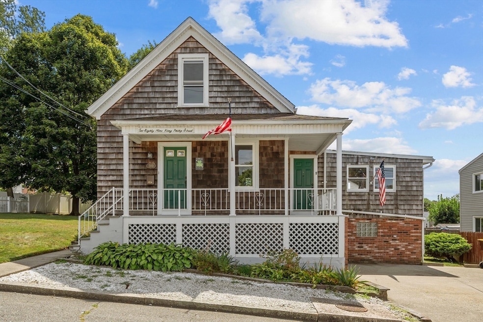
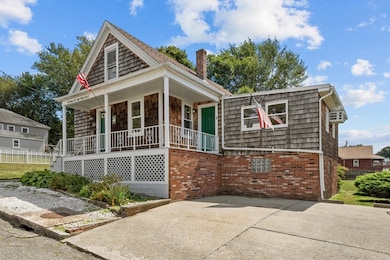
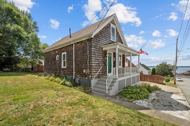
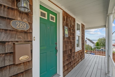
289 King Philip St Fall River, MA 02724
Sandy Beach NeighborhoodEstimated payment $2,176/month
Highlights
- Cape Cod Architecture
- No HOA
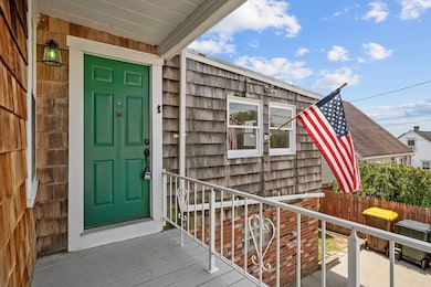
- Porch
- Wood Flooring
- Fenced Yard
- 2-minute walk to Abbott Playground
About This Home
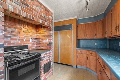
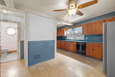
Located at 289 King Philip St, Fall River, MA, this single-family residence in Bristol County presents an inviting home, ready for immediate occupancy. The living room provides a warm and welcoming atmosphere, enhanced by the distinctive wood ceiling overhead and the practical built-in shelves that offer both storage and display space. Imagine relaxing in this space, surrounded by your favorite books and cherished mementos. The kitchen provides a functional and stylish space, featuring a backsplash that adds a touch of elegance, a built-in refrigerator offering a seamless design, and crown molding that enhances the room's overall aesthetic. Envision preparing meals in this thoughtfully designed culinary space. This property includes three bedrooms and one full bathroom, providing comfortable accommodation. The primary bedroom features crown molding that adds a touch of sophistication. A walk-in closet provides generous storage space.

Home Details
Home Type
- Single Family
Est. Annual Taxes
- $4,010
Year Built
- Built in 1930
Lot Details
- 0.25 Acre Lot
- Fenced Yard
- Gentle Sloping Lot
- Property is zoned R-8
Parking
- 1 Car Parking Space
Home Design
- Cape Cod Architecture
- Brick Exterior Construction
- Concrete Perimeter Foundation
Interior Spaces
- 1,340 Sq Ft Home
- Crown Molding
- Partially Finished Basement
- Block Basement Construction
Kitchen
- Range
- Dishwasher
Flooring
- Wood
- Carpet
- Tile
- Vinyl
Bedrooms and Bathrooms
- 3 Bedrooms
- 1 Full Bathroom
Outdoor Features
- Outdoor Storage
- Rain Gutters
- Porch
Utilities
- Cooling System Mounted In Outer Wall Opening
- Heating System Uses Oil
- 200+ Amp Service
- Water Heater
Community Details
- No Home Owners Association
Listing and Financial Details
- Assessor Parcel Number 2820103
Map
Home Values in the Area
Average Home Value in this Area
Tax History
| Year | Tax Paid | Tax Assessment Tax Assessment Total Assessment is a certain percentage of the fair market value that is determined by local assessors to be the total taxable value of land and additions on the property. | Land | Improvement |
|---|---|---|---|---|
| 2025 | $3,825 | $334,100 | $121,100 | $213,000 |
| 2024 | $3,645 | $317,200 | $118,700 | $198,500 |
| 2023 | $3,637 | $296,400 | $107,000 | $189,400 |
| 2022 | $3,266 | $258,800 | $100,900 | $157,900 |
| 2021 | $3,041 | $219,900 | $96,400 | $123,500 |
| 2020 | $2,857 | $197,700 | $92,000 | $105,700 |
| 2019 | $2,891 | $198,300 | $96,200 | $102,100 |
| 2018 | $2,873 | $196,500 | $96,900 | $99,600 |
| 2017 | $2,726 | $194,700 | $96,900 | $97,800 |
| 2016 | $2,625 | $192,600 | $99,900 | $92,700 |
| 2015 | $2,759 | $210,900 | $99,900 | $111,000 |
| 2014 | $2,653 | $210,900 | $99,900 | $111,000 |
Property History
| Date | Event | Price | List to Sale | Price per Sq Ft |
|---|---|---|---|---|
| 09/08/2025 09/08/25 | Pending | -- | -- | -- |
| 08/29/2025 08/29/25 | For Sale | $349,999 | -- | $261 / Sq Ft |
Purchase History
| Date | Type | Sale Price | Title Company |
|---|---|---|---|
| Deed | $370,000 | -- | |
| Deed | $90,000 | -- | |
| Deed | $90,000 | -- |
Mortgage History
| Date | Status | Loan Amount | Loan Type |
|---|---|---|---|
| Open | $358,900 | New Conventional | |
| Previous Owner | $85,000 | No Value Available | |
| Previous Owner | $35,000 | No Value Available | |
| Previous Owner | $50,000 | No Value Available |
Source: MLS Property Information Network (MLS PIN)
MLS Number: 73423445
APN: FALL-000002A-000000-000024
Disclaimer: Certain information contained herein is derived from information provided by parties other than Homes.com. All information provided is deemed reliable, but is not guaranteed to be accurate and should be independently verified.
![]() The property listing data and information, or the Images, set forth herein were provided to MLS Property Information Network, Inc. from third party sources, including sellers, lessors and public records, and were compiled by MLS Property Information Network, Inc. The property listing data and information, and the Images, are for the personal, non-commercial use of consumers having a good faith interest in purchasing or leasing listed properties of the type displayed to them and may not be used for any purpose other than to identify prospective properties which such consumers may have a good faith interest in purchasing or leasing. MLS Property Information Network, Inc. and its subscribers disclaim any and all representations and warranties as to the accuracy of the property listing data and information, or as to the accuracy of any of the Images, set forth herein.
The property listing data and information, or the Images, set forth herein were provided to MLS Property Information Network, Inc. from third party sources, including sellers, lessors and public records, and were compiled by MLS Property Information Network, Inc. The property listing data and information, and the Images, are for the personal, non-commercial use of consumers having a good faith interest in purchasing or leasing listed properties of the type displayed to them and may not be used for any purpose other than to identify prospective properties which such consumers may have a good faith interest in purchasing or leasing. MLS Property Information Network, Inc. and its subscribers disclaim any and all representations and warranties as to the accuracy of the property listing data and information, or as to the accuracy of any of the Images, set forth herein.
- 321 King St
- 160 Foote St
- 616 Woodman St
- 66 Bailey St
- 126 Wheeler St
- 1736 Bay St
- 636-644 Dwelly St
- 15 Higgins St
- 584-586 Mount Hope Ave
- 25 Winward St
- 24 Hall St
- 123 Hall St
- 27 Vista Way
- 59 Mount Hope Ave
- 133 Kempton St
- 909 Dwelly St
- 579 Summit St Unit 3
- 579 Summit St Unit 2
- 391 Clarkson St
- 0 Sampson St