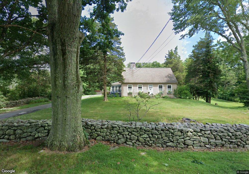
289 Route 148 Killingworth, CT 06419
Estimated Value: $489,479 - $577,000
3
Beds
2
Baths
1,794
Sq Ft
$296/Sq Ft
Est. Value
About This Home
This home is located at 289 Route 148, Killingworth, CT 06419 and is currently estimated at $531,370, approximately $296 per square foot. 289 Route 148 is a home located in Middlesex County with nearby schools including Haddam-Killingworth High School and Haddam-Killingworth Intermediate School.
Ownership History
Date
Name
Owned For
Owner Type
Purchase Details
Closed on
Jun 18, 1996
Sold by
Levenson Dana Robert
Bought by
White Timothy L and White Jennifer M
Current Estimated Value
Home Financials for this Owner
Home Financials are based on the most recent Mortgage that was taken out on this home.
Original Mortgage
$136,000
Interest Rate
7.97%
Mortgage Type
Unknown
Create a Home Valuation Report for This Property
The Home Valuation Report is an in-depth analysis detailing your home's value as well as a comparison with similar homes in the area
Home Values in the Area
Average Home Value in this Area
Purchase History
| Date | Buyer | Sale Price | Title Company |
|---|---|---|---|
| White Timothy L | $170,000 | -- |
Source: Public Records
Mortgage History
| Date | Status | Borrower | Loan Amount |
|---|---|---|---|
| Open | White Timothy L | $153,000 | |
| Closed | White Timothy L | $136,000 | |
| Previous Owner | White Timothy L | $166,500 | |
| Previous Owner | White Timothy L | $14,000 |
Source: Public Records
Tax History Compared to Growth
Tax History
| Year | Tax Paid | Tax Assessment Tax Assessment Total Assessment is a certain percentage of the fair market value that is determined by local assessors to be the total taxable value of land and additions on the property. | Land | Improvement |
|---|---|---|---|---|
| 2025 | $5,690 | $217,000 | $67,200 | $149,800 |
| 2024 | $5,256 | $217,000 | $67,200 | $149,800 |
| 2023 | $5,093 | $217,000 | $67,200 | $149,800 |
| 2022 | $5,039 | $217,000 | $67,200 | $149,800 |
| 2021 | $4,933 | $184,610 | $70,680 | $113,930 |
| 2020 | $4,933 | $184,610 | $70,680 | $113,930 |
| 2019 | $5,071 | $184,610 | $70,680 | $113,930 |
| 2018 | $5,071 | $184,610 | $70,680 | $113,930 |
| 2017 | $5,071 | $184,610 | $70,680 | $113,930 |
| 2016 | $5,137 | $198,410 | $106,050 | $92,360 |
| 2015 | $5,006 | $198,410 | $106,050 | $92,360 |
| 2014 | $4,867 | $198,410 | $106,050 | $92,360 |
Source: Public Records
Map
Nearby Homes
- 275 Route 148
- 24 Boulder Trail
- 511 Route 81
- 10 Whitewood Rd
- 11 Pleasant Trail
- 8 Livemore Trail
- 33 Whitewood Rd
- 14 Kenilworth Dr
- 13 Cranberry Meadow Ln
- 115 Hemlock Dr
- 12 Rachel Ct
- 262 Connecticut 81
- 8 Route 148
- 779 Summer Hill Rd
- 30 Chestnut Hill Rd
- 179 Route 81
- 8 Butter Jones Rd
- 37 Titus Coan Rd
- 48 Shepherds Trail
- 174 Concord Dr