Estimated Value: $694,000 - $977,000
3
Beds
2
Baths
1,790
Sq Ft
$489/Sq Ft
Est. Value
About This Home
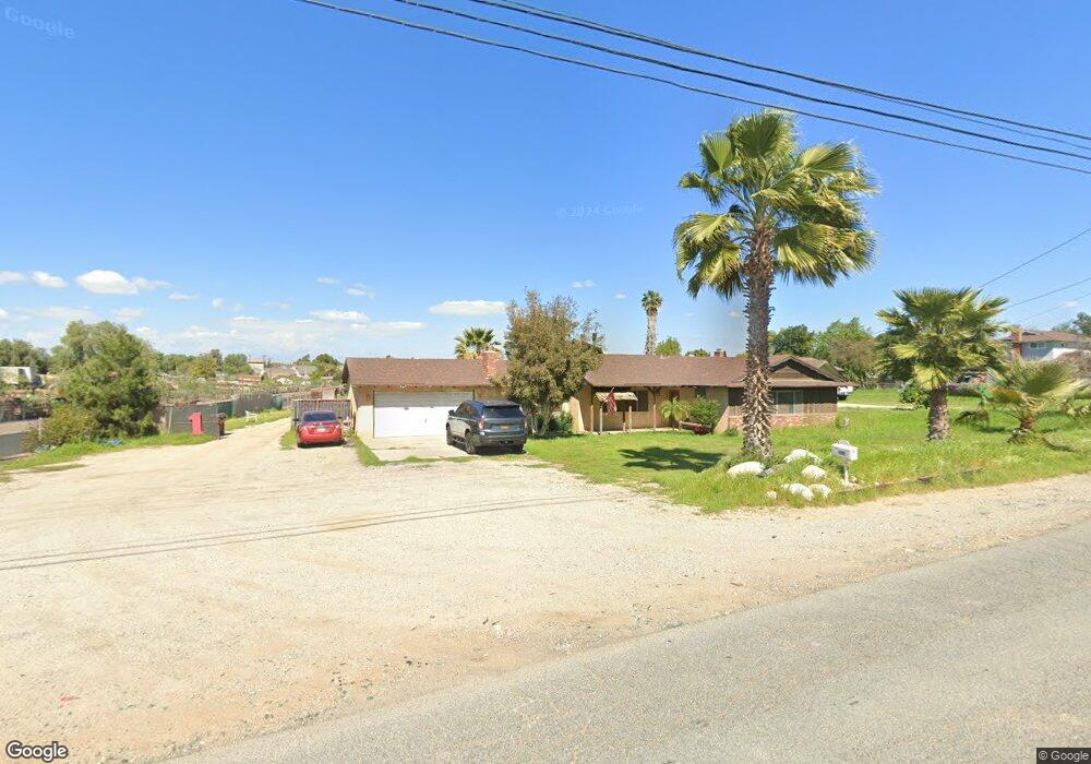
This home is located at 2891 2nd St, Norco, CA 92860 and is currently estimated at $875,050, approximately $488 per square foot. 2891 2nd St is a home located in Riverside County with nearby schools including George Washington Elementary, Auburndale Intermediate, and Norco High School.
Ownership History
Date
Name
Owned For
Owner Type
Purchase Details
Closed on
Sep 16, 2016
Sold by
Scott Robert J
Bought by
Scott Robert John and The Robert John Scott Revocable Living T
Current Estimated Value
Purchase Details
Closed on
Nov 10, 1994
Sold by
Scott Kathleen
Bought by
Scott Robert John
Purchase Details
Closed on
Feb 2, 1994
Sold by
Scott Robert J and Scott Kathy
Bought by
Scott Robert J
Home Financials for this Owner
Home Financials are based on the most recent Mortgage that was taken out on this home.
Original Mortgage
$157,500
Interest Rate
7.1%
Create a Home Valuation Report for This Property
The Home Valuation Report is an in-depth analysis detailing your home's value as well as a comparison with similar homes in the area
Home Values in the Area
Average Home Value in this Area
Purchase History
| Date | Buyer | Sale Price | Title Company |
|---|---|---|---|
| Scott Robert John | -- | None Available | |
| Scott Robert John | -- | First American Title Ins Co | |
| Scott Robert J | -- | Fidelity National Title Ins |
Source: Public Records
Mortgage History
| Date | Status | Borrower | Loan Amount |
|---|---|---|---|
| Closed | Scott Robert J | $157,500 |
Source: Public Records
Tax History
| Year | Tax Paid | Tax Assessment Tax Assessment Total Assessment is a certain percentage of the fair market value that is determined by local assessors to be the total taxable value of land and additions on the property. | Land | Improvement |
|---|---|---|---|---|
| 2025 | $1,830 | $173,099 | $36,656 | $136,443 |
| 2023 | $1,830 | $166,380 | $35,234 | $131,146 |
| 2022 | $1,769 | $163,119 | $34,544 | $128,575 |
| 2021 | $1,732 | $159,921 | $33,867 | $126,054 |
| 2020 | $1,712 | $158,282 | $33,520 | $124,762 |
| 2019 | $1,671 | $155,179 | $32,863 | $122,316 |
| 2018 | $1,631 | $152,137 | $32,219 | $119,918 |
| 2017 | $1,588 | $149,155 | $31,588 | $117,567 |
| 2016 | $1,570 | $146,231 | $30,969 | $115,262 |
| 2015 | $1,535 | $144,036 | $30,504 | $113,532 |
| 2014 | $1,477 | $141,216 | $29,907 | $111,309 |
Source: Public Records
Map
Nearby Homes
- 2904 2nd St
- 2821 Riding Ring Rd
- 1233 Dale Cir
- 1056 Lullaby Ln
- 2386 Hialeah Cir
- 2625 Three Bar Ln
- 974 Nottingham Dr
- 2384 Corydon Ave
- 1775 Acre St
- 915 Auburndale St
- 2354 Corydon Ave
- 1044 Meadowview Ct
- 906 Brandywine Ln
- 901 Primrose Ln
- 871 Kevin Cir
- 1841 Providence Way
- 1118 Fallbrook Dr
- 4058 Sundance Ln
- 868 Pathfinder Way
- 865 Honey Grove Way
Your Personal Tour Guide
Ask me questions while you tour the home.