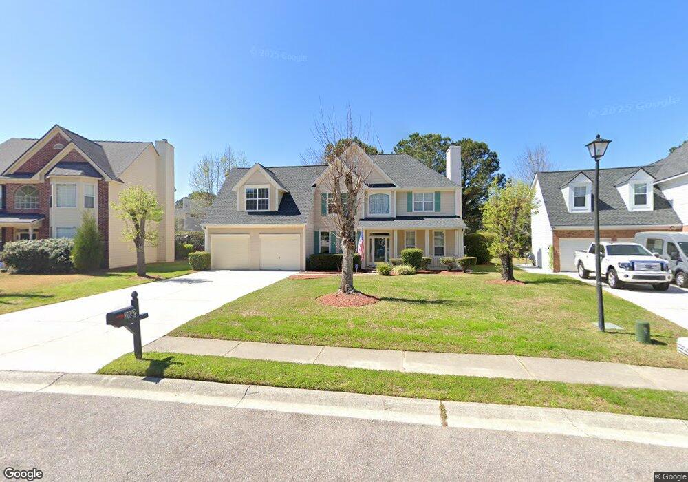
2892 Colonnade Dr Mount Pleasant, SC 29466
Brickyard NeighborhoodEstimated Value: $764,000 - $919,000
4
Beds
3
Baths
2,375
Sq Ft
$346/Sq Ft
Est. Value
About This Home
This home is located at 2892 Colonnade Dr, Mount Pleasant, SC 29466 and is currently estimated at $821,957, approximately $346 per square foot. 2892 Colonnade Dr is a home located in Charleston County with nearby schools including Jennie Moore Elementary School, Laing Middle School, and Wando High School.
Ownership History
Date
Name
Owned For
Owner Type
Purchase Details
Closed on
Apr 13, 2010
Sold by
Mcfadden Daniel T and Mcfadden Kathleen M
Bought by
Baker Robert and Baker Ofelia
Current Estimated Value
Home Financials for this Owner
Home Financials are based on the most recent Mortgage that was taken out on this home.
Original Mortgage
$347,830
Outstanding Balance
$231,322
Interest Rate
4.97%
Mortgage Type
VA
Estimated Equity
$590,635
Purchase Details
Closed on
May 22, 2007
Sold by
Mcfadden Daniel T
Bought by
Mcfadden Kathleen M
Purchase Details
Closed on
Nov 19, 2002
Sold by
Cendant Mobility Financial Corp
Bought by
Mcfadden Daniel T
Purchase Details
Closed on
Jul 23, 2002
Sold by
Leeman Michael H and Leeman Sharon M
Bought by
Cendant Mobility Financial Corp
Create a Home Valuation Report for This Property
The Home Valuation Report is an in-depth analysis detailing your home's value as well as a comparison with similar homes in the area
Home Values in the Area
Average Home Value in this Area
Purchase History
| Date | Buyer | Sale Price | Title Company |
|---|---|---|---|
| Baker Robert | $337,000 | -- | |
| Mcfadden Kathleen M | -- | None Available | |
| Mcfadden Daniel T | $224,800 | -- | |
| Cendant Mobility Financial Corp | $235,000 | -- |
Source: Public Records
Mortgage History
| Date | Status | Borrower | Loan Amount |
|---|---|---|---|
| Open | Baker Robert | $347,830 |
Source: Public Records
Tax History
| Year | Tax Paid | Tax Assessment Tax Assessment Total Assessment is a certain percentage of the fair market value that is determined by local assessors to be the total taxable value of land and additions on the property. | Land | Improvement |
|---|---|---|---|---|
| 2024 | $1,734 | $14,560 | $0 | $0 |
| 2023 | $1,529 | $14,560 | $0 | $0 |
| 2022 | $1,390 | $14,560 | $0 | $0 |
| 2021 | $1,523 | $14,560 | $0 | $0 |
| 2020 | $1,574 | $14,560 | $0 | $0 |
| 2019 | $1,353 | $12,400 | $0 | $0 |
| 2017 | $1,335 | $14,400 | $0 | $0 |
| 2016 | $1,273 | $14,400 | $0 | $0 |
| 2015 | $1,328 | $14,400 | $0 | $0 |
| 2014 | $1,205 | $0 | $0 | $0 |
| 2011 | -- | $0 | $0 | $0 |
Source: Public Records
Map
Nearby Homes
- 2876 Colonnade Dr
- 1336 Wynbrook Trace
- 0 Tugman Ln Unit 26003971
- 1301 Merchant Ct
- 2730 Seastrand Ln
- 1265 Allusion Ln
- 1250 Abercorn Trace
- 3046 Emma Ln
- 3064 Emma Ln
- 3157 Morningdale Dr
- 2713 Gaston Gate
- 1415 Black River Dr
- 3221 Seaborn Dr
- 1295 Chrismill Ln
- 1250 Old Ivy Way
- 1141 Wexford Park
- 2834 Parkers Landing Rd
- 1127 Hamlin Rd
- 1200 Dingle Rd
- 1215 Dingle Rd
- 2888 Colonnade Dr
- 2896 Colonnade Dr
- 1352 Wynbrook Trace
- 2884 Colonnade Dr
- 1400 Lakecrest Ct
- 1351 Wynbrook Trace
- 1348 Wynbrook Trace
- 2880 Colonnade Dr
- 1399 Lakecrest Ct
- 2748 Waterpointe Cir
- 1396 Lakecrest Ct
- 1349 Wynbrook Trace
- 2744 Waterpointe Cir
- 1344 Wynbrook Trace
- 1395 Lakecrest Ct
- 2752 Waterpointe Cir
- 1392 Lakecrest Ct
- 2798 Seastrand Ln
- 1345 Wynbrook Trace
- 1260 Colfax Ct
Your Personal Tour Guide
Ask me questions while you tour the home.