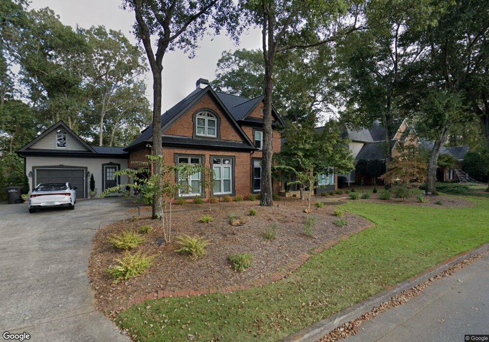
29 29 Westchester Dr Cartersville, GA 30120
Estimated Value: $673,000 - $780,000
5
Beds
6
Baths
4,759
Sq Ft
$152/Sq Ft
Est. Value
About This Home
This home is located at 29 29 Westchester Dr, Cartersville, GA 30120 and is currently estimated at $721,454, approximately $151 per square foot. 29 29 Westchester Dr is a home located in Bartow County with nearby schools including Cartersville Primary School, Cartersville Elementary School, and Cartersville Middle School.
Ownership History
Date
Name
Owned For
Owner Type
Purchase Details
Closed on
Jun 27, 2017
Sold by
Taylor Harold F
Bought by
Dyer Christopher L
Current Estimated Value
Home Financials for this Owner
Home Financials are based on the most recent Mortgage that was taken out on this home.
Original Mortgage
$309,523
Outstanding Balance
$257,514
Interest Rate
3.94%
Mortgage Type
FHA
Estimated Equity
$463,940
Purchase Details
Closed on
Jun 23, 2013
Sold by
Taylor Pamela N
Bought by
Taylor Harold F
Purchase Details
Closed on
Feb 13, 2013
Sold by
Taylor Pamela
Bought by
Taylor Harold F
Create a Home Valuation Report for This Property
The Home Valuation Report is an in-depth analysis detailing your home's value as well as a comparison with similar homes in the area
Home Values in the Area
Average Home Value in this Area
Purchase History
| Date | Buyer | Sale Price | Title Company |
|---|---|---|---|
| Dyer Christopher L | $338,000 | -- | |
| Taylor Harold F | -- | -- | |
| Taylor Harold F | -- | -- |
Source: Public Records
Mortgage History
| Date | Status | Borrower | Loan Amount |
|---|---|---|---|
| Open | Dyer Christopher L | $309,523 |
Source: Public Records
Tax History Compared to Growth
Tax History
| Year | Tax Paid | Tax Assessment Tax Assessment Total Assessment is a certain percentage of the fair market value that is determined by local assessors to be the total taxable value of land and additions on the property. | Land | Improvement |
|---|---|---|---|---|
| 2024 | $6,877 | $274,363 | $35,600 | $238,763 |
| 2023 | $6,877 | $269,758 | $35,600 | $234,158 |
| 2022 | $6,174 | $233,616 | $30,000 | $203,616 |
| 2021 | $4,794 | $176,448 | $30,000 | $146,448 |
| 2020 | $4,640 | $164,448 | $18,000 | $146,448 |
| 2019 | $4,244 | $146,368 | $18,000 | $128,368 |
| 2018 | $4,220 | $144,510 | $18,000 | $126,510 |
| 2017 | $4,258 | $144,510 | $18,000 | $126,510 |
| 2016 | $4,054 | $135,440 | $18,000 | $117,440 |
| 2015 | $3,580 | $122,480 | $18,000 | $104,480 |
| 2014 | $3,817 | $127,440 | $18,000 | $109,440 |
| 2013 | -- | $102,840 | $14,000 | $88,840 |
Source: Public Records
Map
Nearby Homes
- 25 Westchester Dr
- 6 Devon Ct
- 10 Buckingham Ct
- 11 Hampton Ln
- 5 Pembroke Ln
- 14 Town And Country Dr
- 5 Ridgewood Dr
- 150 Old Mill Rd Unit 402
- 150 Old Mill Rd Unit 308
- 150 Old Mill Rd Unit 318
- 235 Grand Central Way
- 44 River Shoals Dr SE
- 26 Indian Trail SE
- 111 Tanglewood Dr
- 0 Old Alabama Rd SE Unit 7652936
- 0 Old Alabama Rd SE Unit 10609115
- 9 Hillshire Dr
- 308 Etowah Dr
- 21 Stewart Dr
- 29 Westchester Dr
- 27 Westchester Dr
- 31 Westchester Dr
- 33 Westchester Dr
- 28 Westchester Dr
- 30 Westchester Dr
- 26 Westchester Dr
- 32 Westchester Dr
- 35 Westchester Dr
- 35 Westchester Dr
- 35 Westchester Dr
- 35 Westchester Dr
- 35 Westchester Dr
- 35 Westchester Dr
- 35 Westchester Dr
- 35 Westchester Dr
- 35 Westchester Dr
- 35 Westchester Dr
- 35 Westchester Dr
- 35 Westchester Dr