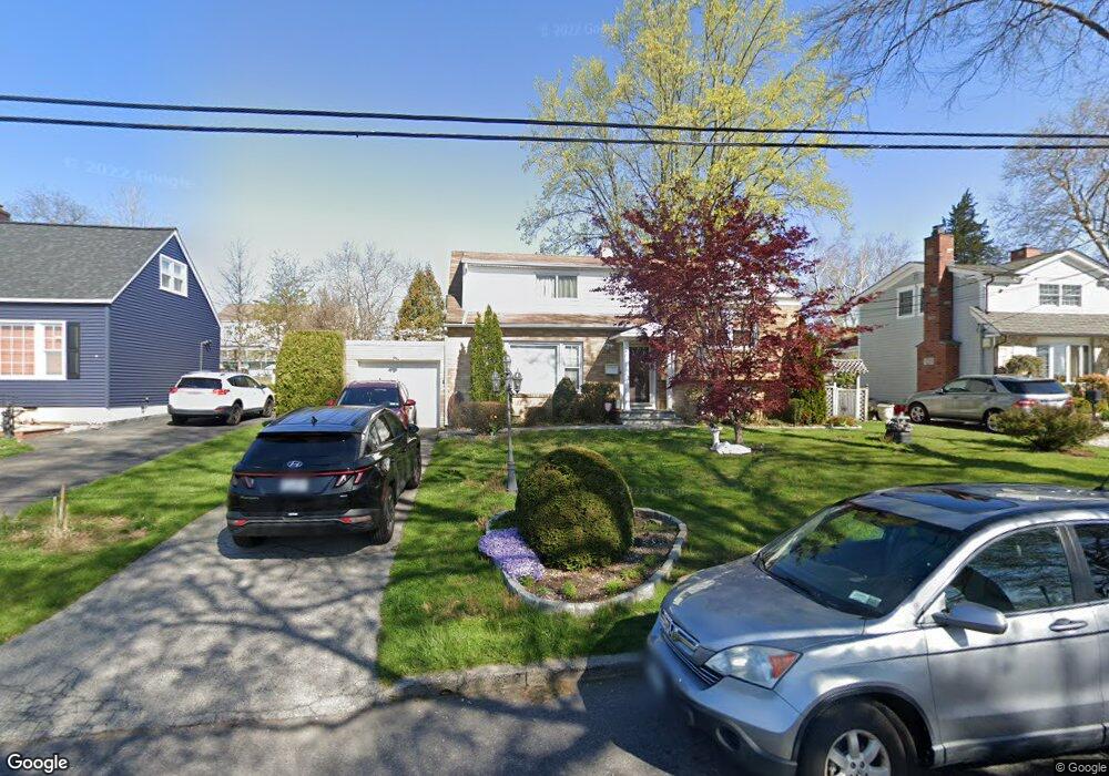
29 Allendale Rd Yonkers, NY 10710
Northeast Yonkers NeighborhoodEstimated Value: $756,000 - $850,000
4
Beds
2
Baths
1,648
Sq Ft
$480/Sq Ft
Est. Value
About This Home
This home is located at 29 Allendale Rd, Yonkers, NY 10710 and is currently estimated at $790,809, approximately $479 per square foot. 29 Allendale Rd is a home located in Westchester County.
Ownership History
Date
Name
Owned For
Owner Type
Purchase Details
Closed on
Jan 30, 2004
Sold by
Andrade Carmen Y and Andrade Norman J
Bought by
Jacobson Sheryl F and Reynoso Marina
Current Estimated Value
Purchase Details
Closed on
Feb 8, 2002
Sold by
Provenzano Concetta
Bought by
Provenzano Charles S
Purchase Details
Closed on
Feb 17, 1998
Sold by
Nelson Albert and Nelson Toby
Bought by
Andrade Norman J and Andrade Carmen Y
Create a Home Valuation Report for This Property
The Home Valuation Report is an in-depth analysis detailing your home's value as well as a comparison with similar homes in the area
Home Values in the Area
Average Home Value in this Area
Purchase History
| Date | Buyer | Sale Price | Title Company |
|---|---|---|---|
| Jacobson Sheryl F | $429,000 | The Judicial Title Ins Agenc | |
| Provenzano Charles S | -- | -- | |
| Andrade Norman J | $198,000 | Commonwealth Land Title Ins |
Source: Public Records
Tax History Compared to Growth
Tax History
| Year | Tax Paid | Tax Assessment Tax Assessment Total Assessment is a certain percentage of the fair market value that is determined by local assessors to be the total taxable value of land and additions on the property. | Land | Improvement |
|---|---|---|---|---|
| 2024 | $1,924 | $10,800 | $3,100 | $7,700 |
| 2023 | $1,914 | $10,800 | $3,100 | $7,700 |
| 2022 | $1,902 | $10,800 | $3,100 | $7,700 |
| 2021 | $8,312 | $10,800 | $3,100 | $7,700 |
| 2020 | $8,219 | $10,800 | $3,100 | $7,700 |
| 2019 | $9,924 | $10,800 | $3,100 | $7,700 |
| 2018 | $7,581 | $10,800 | $3,100 | $7,700 |
| 2017 | $0 | $10,800 | $3,100 | $7,700 |
| 2016 | $8,678 | $10,800 | $3,100 | $7,700 |
| 2015 | -- | $10,800 | $3,100 | $7,700 |
| 2014 | -- | $12,200 | $3,100 | $9,100 |
| 2013 | -- | $12,200 | $3,100 | $9,100 |
Source: Public Records
Map
Nearby Homes
- 15 Bristol Place
- 66 Crisfield St Unit 3Y
- 66 Crisfield St Unit 1D
- 66 Crisfield St Unit 3D
- 12 Bacon Place
- 61 Newport Rd
- 1 Remsen Rd Unit 4J
- 1 Remsen Rd Unit 1F
- 1 Remsen Rd Unit 2F
- 33 Eisenhower Dr
- 11 Jackson Ave Unit 4
- 49 Gail Rd
- 127 Crisfield St
- 2 Dorchester Dr
- 74 Chester Dr
- 48 Elissa Ln
- 397 Concord Rd
- 57 Roundtop Rd
- 2035 Central Park Ave Unit 1M
- 2035 Central Park Ave Unit 1S