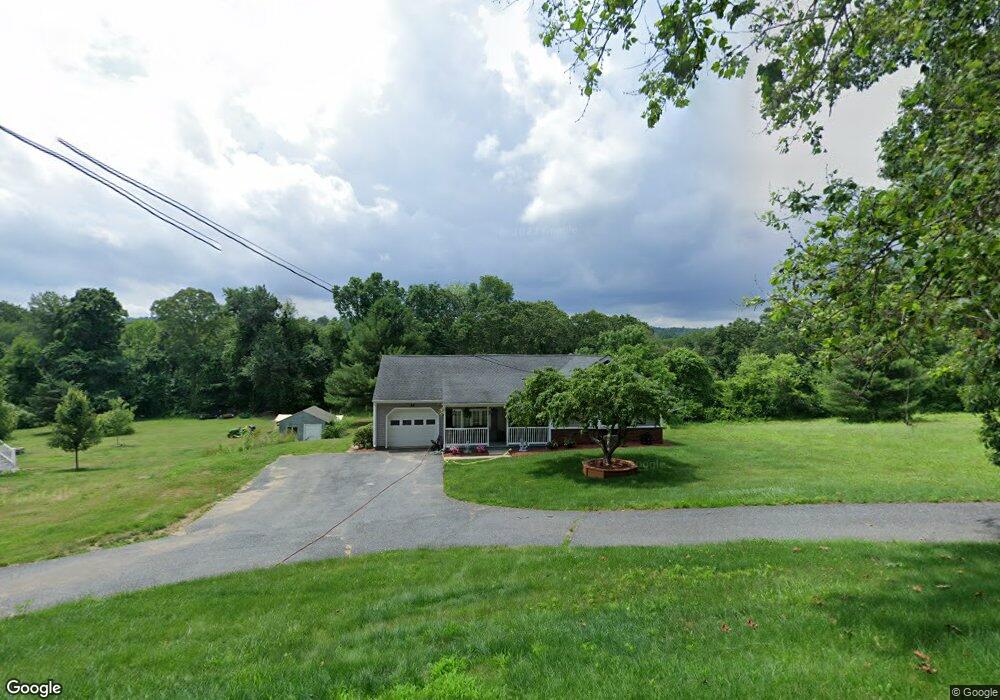
29 Blackstone St Sutton, MA 01590
Estimated Value: $415,000 - $574,000
3
Beds
1
Bath
1,831
Sq Ft
$261/Sq Ft
Est. Value
About This Home
This home is located at 29 Blackstone St, Sutton, MA 01590 and is currently estimated at $477,076, approximately $260 per square foot. 29 Blackstone St is a home located in Worcester County with nearby schools including Sutton Elementary School, Sutton Middle School, and Sutton High School.
Ownership History
Date
Name
Owned For
Owner Type
Purchase Details
Closed on
Jul 28, 2025
Sold by
Henault Ft and Henault
Bought by
Adams Eric T
Current Estimated Value
Purchase Details
Closed on
Jun 21, 2017
Sold by
Henault Gerald A and Henault Susan L
Bought by
Henault Ft and Henault
Purchase Details
Closed on
Mar 3, 1980
Bought by
Henault Gerald A and Henault Susan L
Create a Home Valuation Report for This Property
The Home Valuation Report is an in-depth analysis detailing your home's value as well as a comparison with similar homes in the area
Home Values in the Area
Average Home Value in this Area
Purchase History
| Date | Buyer | Sale Price | Title Company |
|---|---|---|---|
| Adams Eric T | $400,000 | -- | |
| Adams Eric T | $400,000 | -- | |
| Henault Ft | -- | -- | |
| Henault Ft | -- | -- | |
| Henault Gerald A | -- | -- |
Source: Public Records
Tax History
| Year | Tax Paid | Tax Assessment Tax Assessment Total Assessment is a certain percentage of the fair market value that is determined by local assessors to be the total taxable value of land and additions on the property. | Land | Improvement |
|---|---|---|---|---|
| 2025 | $4,930 | $395,700 | $171,700 | $224,000 |
| 2024 | $5,061 | $392,600 | $163,900 | $228,700 |
| 2023 | $4,796 | $340,600 | $148,800 | $191,800 |
| 2022 | $4,237 | $273,000 | $113,700 | $159,300 |
| 2021 | $4,326 | $264,900 | $113,700 | $151,200 |
| 2020 | $2,999 | $258,400 | $113,700 | $144,700 |
| 2019 | $4,094 | $241,400 | $113,700 | $127,700 |
| 2018 | $2,682 | $233,300 | $113,700 | $119,600 |
| 2017 | $3,307 | $195,000 | $72,200 | $122,800 |
| 2016 | $3,260 | $190,100 | $72,200 | $117,900 |
| 2015 | $3,140 | $183,600 | $72,200 | $111,400 |
| 2014 | $3,129 | $179,400 | $74,500 | $104,900 |
Source: Public Records
Map
Nearby Homes
- 66 Buttonwood Ave
- 8 Autumn Gate Cir
- Lot 1 Cooper Rd
- 20 Millers Way Unit C
- 19 Fitzpatrick Rd
- 9 Danielle Dr
- 109 Main St
- 46 Lexington Rd
- 64 Fisherville Terrace
- 62 Fisherville Terrace
- 58 Fisherville Terrace
- 79 Fisherville Terrace
- 53 Fisherville Terrace
- 55 Fisherville Terrace
- 44 Fisherville Terrace
- 20 Woodridge Rd
- 5 Wildflower Dr
- 5 Mogren Dr
- 2 Jessica j Dr
- 4 Jessica j Dr
- 27 Blackstone St
- 23 Blackstone St
- 32 Blackstone St
- 36 Blackstone St
- 28 Blackstone St
- 24 Blackstone St
- 19 Blackstone St
- 20 Blackstone St
- 17 Blackstone St
- 41 Ariel Cir Unit 41
- 34 Ariel Cir Unit 34
- 33 Ariel Cir Unit 33
- 32 Ariel Cir Unit 32
- 44 Ariel Cir Unit 44
- 46 Ariel Cir Unit 46
- 16 Blackstone St
- 11 Marks Way
- 148 Ariel Cir
- 152 Ariel Cir
- 154 Ariel Cir
Your Personal Tour Guide
Ask me questions while you tour the home.