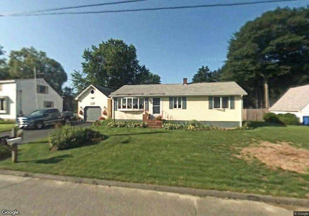
29 Declaration Dr Westbrook, ME 04092
Estimated Value: $453,021 - $501,000
2
Beds
3
Baths
1,482
Sq Ft
$326/Sq Ft
Est. Value
About This Home
This home is located at 29 Declaration Dr, Westbrook, ME 04092 and is currently estimated at $483,755, approximately $326 per square foot. 29 Declaration Dr is a home located in Cumberland County with nearby schools including Westbrook High School, St. Brigid School, and Breakwater School.
Ownership History
Date
Name
Owned For
Owner Type
Purchase Details
Closed on
Oct 2, 2018
Sold by
Bouchard Rosmarie and Bouchard Rosemarie
Bought by
Bouchard Danielle S
Current Estimated Value
Home Financials for this Owner
Home Financials are based on the most recent Mortgage that was taken out on this home.
Original Mortgage
$225,000
Interest Rate
4.5%
Mortgage Type
New Conventional
Create a Home Valuation Report for This Property
The Home Valuation Report is an in-depth analysis detailing your home's value as well as a comparison with similar homes in the area
Purchase History
| Date | Buyer | Sale Price | Title Company |
|---|---|---|---|
| Bouchard Danielle S | -- | -- |
Source: Public Records
Mortgage History
| Date | Status | Borrower | Loan Amount |
|---|---|---|---|
| Closed | Bouchard Danielle S | $225,000 |
Source: Public Records
Tax History
| Year | Tax Paid | Tax Assessment Tax Assessment Total Assessment is a certain percentage of the fair market value that is determined by local assessors to be the total taxable value of land and additions on the property. | Land | Improvement |
|---|---|---|---|---|
| 2023 | $4,599 | $275,700 | $84,700 | $191,000 |
| 2022 | $4,172 | $230,500 | $70,600 | $159,900 |
| 2021 | $4,110 | $230,500 | $70,600 | $159,900 |
| 2020 | $4,117 | $230,500 | $70,600 | $159,900 |
| 2019 | $4,117 | $230,500 | $70,600 | $159,900 |
| 2018 | $2,858 | $173,200 | $61,400 | $111,800 |
| 2017 | $3,270 | $173,200 | $61,400 | $111,800 |
| 2016 | $3,187 | $173,200 | $61,400 | $111,800 |
| 2015 | $3,111 | $173,200 | $61,400 | $111,800 |
| 2014 | $2,979 | $173,200 | $61,400 | $111,800 |
| 2013 | $2,979 | $173,200 | $61,400 | $111,800 |
Source: Public Records
Map
Nearby Homes
- 7 Kasseys Way Unit 5
- 18 Summit Cir
- Lot 15&16 Chickadee Ln
- 22 Collins Place Dr Unit 4
- 60 Euclid Ave
- 0 Reed St
- 858 Riverside St
- 95 Lane Ave
- 189 Holm Ave
- 7 Apex Dr Unit 2
- 5 Apex Dr Unit 1
- 7 Collins Place Unit 6
- 97 Warren Ave
- 19 Birchvale Dr
- 311 Main St
- 383 Main St
- 96 Holm Ave
- 290 Bridgton Rd Unit 1
- 22 Berkeley St
- 1638 Forest Ave
- 31 Declaration Dr
- 27 Declaration Dr
- 50 Independence Dr
- 28 Declaration Dr
- 46 Independence Dr
- 25 Declaration Dr
- 33 Declaration Dr
- 54 Independence Dr
- 65 Constitution Dr
- 66 Constitution Dr
- 30 Declaration Dr
- 42 Independence Dr
- 23 Declaration Dr
- 63 Constitution Dr
- 12 Pioneer Rd
- 49 Independence Dr
- 64 Constitution Dr
- 58 Independence Dr
- 10 Pioneer Rd
- 61 Independence Dr
Your Personal Tour Guide
Ask me questions while you tour the home.