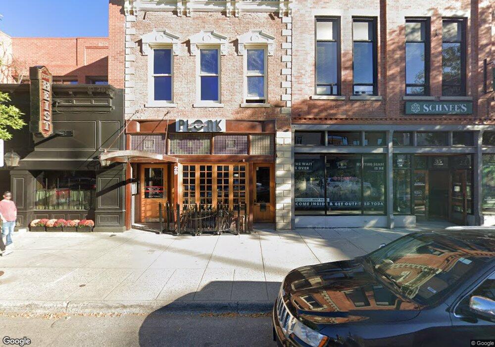
29 E Main St Bozeman, MT 59715
South Central NeighborhoodEstimated Value: $2,808,950
Studio
--
Bath
6,883
Sq Ft
$408/Sq Ft
Est. Value
About This Home
This home is located at 29 E Main St, Bozeman, MT 59715 and is currently priced at $2,808,950, approximately $408 per square foot. 29 E Main St is a home located in Gallatin County with nearby schools including Hawthorne Elementary School, Chief Joseph Middle School, and Bozeman High School.
Ownership History
Date
Name
Owned For
Owner Type
Purchase Details
Closed on
Jun 4, 2019
Sold by
Splittstoesser Kathleen C and Gaudet Karen G
Bought by
Cell Block B Llc
Current Estimated Value
Home Financials for this Owner
Home Financials are based on the most recent Mortgage that was taken out on this home.
Original Mortgage
$1,480,000
Outstanding Balance
$1,139,570
Interest Rate
4.1%
Mortgage Type
Commercial
Purchase Details
Closed on
Dec 22, 2005
Sold by
Kilbride Daniel D
Bought by
Kilbride Daniel D
Create a Home Valuation Report for This Property
The Home Valuation Report is an in-depth analysis detailing your home's value as well as a comparison with similar homes in the area
Home Values in the Area
Average Home Value in this Area
Purchase History
| Date | Buyer | Sale Price | Title Company |
|---|---|---|---|
| Cell Block B Llc | -- | Montana Title And Escrow | |
| Kilbride Daniel D | -- | Insured Titles |
Source: Public Records
Mortgage History
| Date | Status | Borrower | Loan Amount |
|---|---|---|---|
| Open | Cell Block B Llc | $1,480,000 |
Source: Public Records
Tax History
| Year | Tax Paid | Tax Assessment Tax Assessment Total Assessment is a certain percentage of the fair market value that is determined by local assessors to be the total taxable value of land and additions on the property. | Land | Improvement |
|---|---|---|---|---|
| 2025 | $24,632 | $2,665,130 | $0 | $0 |
| 2024 | $25,272 | $2,765,304 | $0 | $0 |
| 2023 | $24,395 | $2,765,304 | $0 | $0 |
| 2022 | $21,491 | $2,029,271 | $0 | $0 |
| 2021 | $21,850 | $1,871,761 | $0 | $0 |
| 2020 | $20,156 | $1,690,000 | $0 | $0 |
| 2019 | $20,621 | $2,237,781 | $0 | $0 |
| 2018 | $13,010 | $988,100 | $0 | $0 |
| 2017 | $12,898 | $988,100 | $0 | $0 |
| 2016 | $11,620 | $882,200 | $0 | $0 |
| 2015 | $11,631 | $882,200 | $0 | $0 |
| 2014 | $10,738 | $671,149 | $0 | $0 |
Source: Public Records
Map
Nearby Homes
- 5 W Mendenhall St Unit 510
- 5 W Mendenhall St Unit 410
- 5 W Mendenhall St Unit 414
- 37 W Main St Unit A
- 19 E Lamme St
- 201 & 201 1/2 N Black Ave
- 116 N Bozeman Ave Unit 202
- 116 N Bozeman Ave Unit 404
- 116 N Bozeman Ave Unit 305
- TBD Laurel Pkwy Unit PA-8
- 301 N Black Ave
- 309 N Black Ave
- 209 S Tracy Ave
- 315 N Tracy Ave Unit 207
- 315 N Tracy Ave Unit 604
- 315 N Tracy Ave Unit 301
- 315 N Tracy Ave Unit 406
- 315 N Tracy Ave Unit 308
- 315 N Tracy Ave Unit 407
- 315 N Tracy Ave Unit 104
- 27 E Main St Unit D & E
- 27 E Main St
- 33 N Black Ave
- 23 E Main St
- 23 E Main St
- 41 N Black Ave
- Lot 1 Block 6 the Crossing
- Restaurant Group With Excellent Reputation and Highly Profitable
- 9 E Main St Unit B1
- 9 E Main St Unit 101
- 9 E Main St Unit 201
- 7-9 E Main St
- 101 E Main St
- 101 E Main St
- 101 E Main St
- 101 E Main St
- 101 E Main St
- 101 E Main St
- 101 E Main St
- 21 S Black Ave Unit 27
Your Personal Tour Guide
Ask me questions while you tour the home.