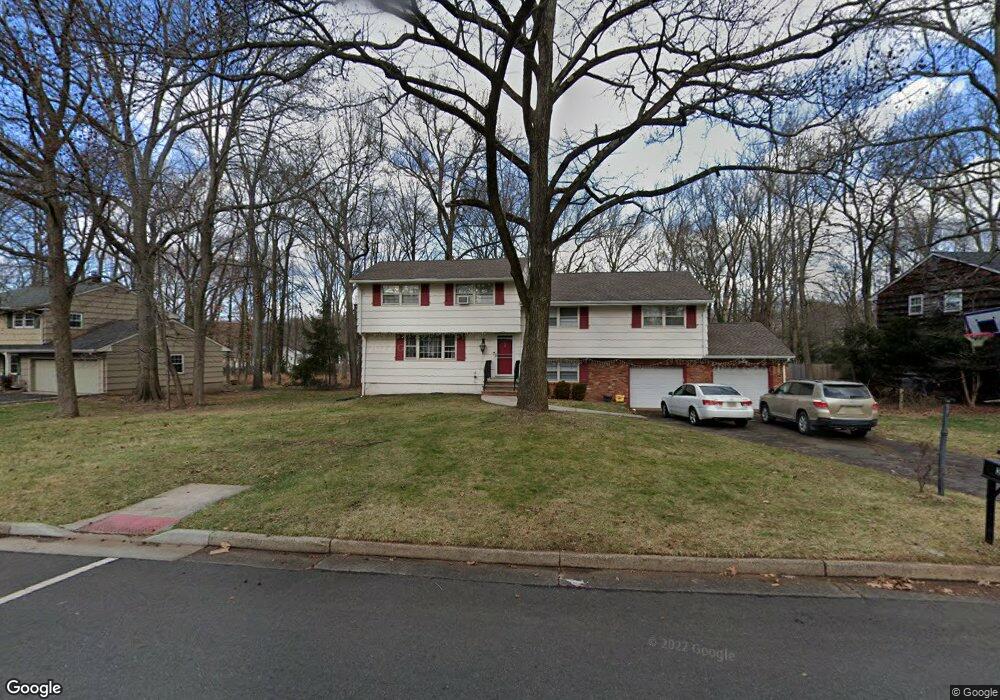
29 Huntington Rd Edison, NJ 08820
Estimated Value: $884,742 - $1,091,000
4
Beds
3
Baths
2,202
Sq Ft
$452/Sq Ft
Est. Value
About This Home
This home is located at 29 Huntington Rd, Edison, NJ 08820 and is currently estimated at $995,936, approximately $452 per square foot. 29 Huntington Rd is a home located in Middlesex County with nearby schools including Menlo Park Elementary School, Woodrow Wilson Middle School, and J.P. Stevens High School.
Ownership History
Date
Name
Owned For
Owner Type
Purchase Details
Closed on
Oct 7, 2016
Sold by
Singh Sumit and Singh Rinky
Bought by
Singh Sumit and Singh Rinky
Current Estimated Value
Home Financials for this Owner
Home Financials are based on the most recent Mortgage that was taken out on this home.
Original Mortgage
$416,250
Outstanding Balance
$340,203
Interest Rate
4.09%
Mortgage Type
New Conventional
Estimated Equity
$655,733
Purchase Details
Closed on
Aug 14, 2015
Sold by
Eng Bfred and Eng Suzanne
Bought by
Singh Smith
Purchase Details
Closed on
Aug 5, 1997
Sold by
Oberlander Robert
Bought by
Eng Fred and Eng Suzanne
Home Financials for this Owner
Home Financials are based on the most recent Mortgage that was taken out on this home.
Original Mortgage
$200,000
Interest Rate
7.5%
Create a Home Valuation Report for This Property
The Home Valuation Report is an in-depth analysis detailing your home's value as well as a comparison with similar homes in the area
Home Values in the Area
Average Home Value in this Area
Purchase History
| Date | Buyer | Sale Price | Title Company |
|---|---|---|---|
| Singh Sumit | -- | None Available | |
| Singh Smith | $564,000 | None Available | |
| Eng Fred | $287,500 | -- |
Source: Public Records
Mortgage History
| Date | Status | Borrower | Loan Amount |
|---|---|---|---|
| Open | Singh Sumit | $416,250 | |
| Previous Owner | Eng Fred | $200,000 |
Source: Public Records
Tax History Compared to Growth
Tax History
| Year | Tax Paid | Tax Assessment Tax Assessment Total Assessment is a certain percentage of the fair market value that is determined by local assessors to be the total taxable value of land and additions on the property. | Land | Improvement |
|---|---|---|---|---|
| 2025 | $14,716 | $247,200 | $123,100 | $124,100 |
| 2024 | $14,637 | $247,200 | $123,100 | $124,100 |
| 2023 | $14,637 | $247,200 | $123,100 | $124,100 |
| 2022 | $14,642 | $247,200 | $123,100 | $124,100 |
| 2021 | $14,048 | $247,200 | $123,100 | $124,100 |
| 2020 | $14,459 | $247,200 | $123,100 | $124,100 |
| 2019 | $13,095 | $247,200 | $123,100 | $124,100 |
| 2018 | $12,857 | $247,200 | $123,100 | $124,100 |
| 2017 | $12,733 | $247,200 | $123,100 | $124,100 |
| 2016 | $12,498 | $247,200 | $123,100 | $124,100 |
| 2015 | $12,024 | $247,200 | $123,100 | $124,100 |
| 2014 | $11,683 | $247,200 | $123,100 | $124,100 |
Source: Public Records
Map
Nearby Homes
- 41 Oliver Ave
- 33 Nottingham Rd
- 34 Nottingham Rd
- 9 Marlin Ave W
- 25 Lamar Ave
- 177 Mundy Ave
- 29 Remington Dr
- 354 Plainfield Rd
- 24 Norton St
- 454 Plainfield Rd
- 6 Sunset Ave
- 513 Grove Ave
- 133 Christie St
- 26 Harding Ave
- 3 Anthony Ave
- 3996 Park Ave
- 21 Williams Rd
- 16 Stephenville Pkwy
- 9 Links Dr
- 64 Richard Rd
- 27 Huntington Rd
- 31 Huntington Rd
- 25 Huntington Rd
- 102 Stephenville Pkwy
- 33 Huntington Rd
- 106 Stephenville Pkwy
- 26 Huntington Rd
- 28 Huntington Rd
- 32 Huntington Rd
- 4 Hadfield Rd
- 100 Stephenville Pkwy
- 23 Huntington Rd
- 108 Stephenville Pkwy
- 35 Huntington Rd
- 98 Stephenville Pkwy
- 34 Huntington Rd
- 96 Stephenville Pkwy
- 22 Huntington Rd
- 21 Huntington Rd
- 4 Midland Rd