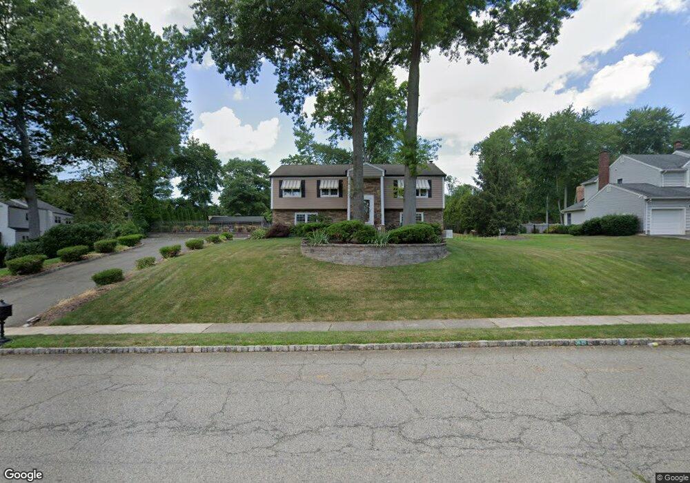
29 Independence Dr Whippany, NJ 07981
Estimated Value: $876,993 - $1,079,000
Studio
--
Bath
3,162
Sq Ft
$304/Sq Ft
Est. Value
About This Home
This home is located at 29 Independence Dr, Whippany, NJ 07981 and is currently estimated at $959,998, approximately $303 per square foot. 29 Independence Dr is a home located in Morris County with nearby schools including Whippany Park High School, Arrow Academy, and The Morristown-Beard School.
Ownership History
Date
Name
Owned For
Owner Type
Purchase Details
Closed on
Apr 30, 1997
Sold by
Potkay Eugene and Potkay Wendy Ann
Bought by
Abbott James P and Abbott Cheryl A
Current Estimated Value
Home Financials for this Owner
Home Financials are based on the most recent Mortgage that was taken out on this home.
Original Mortgage
$246,000
Outstanding Balance
$30,123
Interest Rate
7.85%
Estimated Equity
$929,875
Create a Home Valuation Report for This Property
The Home Valuation Report is an in-depth analysis detailing your home's value as well as a comparison with similar homes in the area
Home Values in the Area
Average Home Value in this Area
Purchase History
| Date | Buyer | Sale Price | Title Company |
|---|---|---|---|
| Abbott James P | $307,500 | -- |
Source: Public Records
Mortgage History
| Date | Status | Borrower | Loan Amount |
|---|---|---|---|
| Open | Abbott James P | $246,000 |
Source: Public Records
Tax History
| Year | Tax Paid | Tax Assessment Tax Assessment Total Assessment is a certain percentage of the fair market value that is determined by local assessors to be the total taxable value of land and additions on the property. | Land | Improvement |
|---|---|---|---|---|
| 2025 | $11,824 | $560,900 | $239,100 | $321,800 |
| 2024 | $11,773 | $560,900 | $239,100 | $321,800 |
| 2023 | $11,773 | $560,900 | $239,100 | $321,800 |
| 2022 | $10,769 | $560,900 | $239,100 | $321,800 |
| 2021 | $10,769 | $560,900 | $239,100 | $321,800 |
| 2020 | $10,579 | $560,900 | $239,100 | $321,800 |
| 2019 | $10,612 | $560,900 | $239,100 | $321,800 |
| 2018 | $10,427 | $560,900 | $239,100 | $321,800 |
| 2017 | $10,119 | $560,900 | $239,100 | $321,800 |
| 2016 | $9,973 | $560,900 | $239,100 | $321,800 |
| 2015 | $9,575 | $560,900 | $239,100 | $321,800 |
| 2014 | $9,367 | $560,900 | $239,100 | $321,800 |
Source: Public Records
Map
Nearby Homes
- 39 Deerfield Rd
- 2903 Appleton Way Unit 2903
- 17 Hilltop Cir
- 96 Parsippany Rd
- 30 Polhemus Terrace
- 68 Fairchild Place
- 25 Washington Ave
- 7 Manchester Dr
- 100 Louis St
- 601 Monroe Ct
- 201 Monroe Ct
- 140 Sunrise Dr
- 4 Forest Hill Ct
- 125 Park Ave
- 100 Troy Hills Rd
- 115 Griffith Dr
- 70 Tiffany Dr
- 104 Ridgedale Ave
- 23 Fillmore Dr
- 1 Glenbrook Ct
- 2 Heritage Ln
- 31 Independence Dr
- 3 Lexington Ct
- 4 Heritage Ln
- 28 Independence Dr
- 26 Independence Dr
- 5 Lexington Ct
- 30 Independence Dr
- 24 Independence Dr
- 1 Heritage Ln
- 22 Independence Dr
- 6 Lexington Ct
- 4 Lexington Ct
- 5 Heritage Ln
- 2 Lexington Ct
- 10 Brandywine Ct
- 8 Brandywine Ct
- 6 Brandywine Ct
- 20 Independence Dr
- 12 Brandywine Ct
Your Personal Tour Guide
Ask me questions while you tour the home.