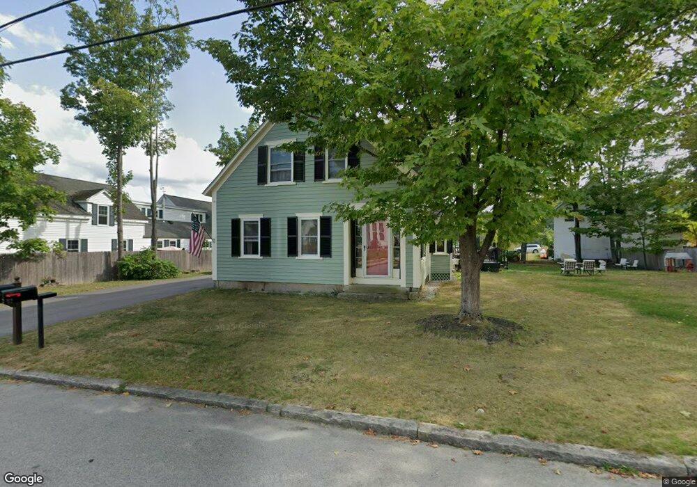
29 Maple St Wilton, NH 03086
Estimated Value: $390,000 - $594,000
4
Beds
2
Baths
2,309
Sq Ft
$195/Sq Ft
Est. Value
About This Home
This home is located at 29 Maple St, Wilton, NH 03086 and is currently estimated at $449,988, approximately $194 per square foot. 29 Maple St is a home located in Hillsborough County with nearby schools including Florence Rideout Elementary School, Wilton-Lyndeborough Cooperative Middle School, and Wilton-Lyndeborough Cooperative High School.
Ownership History
Date
Name
Owned For
Owner Type
Purchase Details
Closed on
May 24, 1999
Sold by
Savage Julia L
Bought by
Meltzer Alison B and Meltzer Benjamin
Current Estimated Value
Home Financials for this Owner
Home Financials are based on the most recent Mortgage that was taken out on this home.
Original Mortgage
$103,937
Outstanding Balance
$24,357
Interest Rate
6.88%
Estimated Equity
$425,631
Create a Home Valuation Report for This Property
The Home Valuation Report is an in-depth analysis detailing your home's value as well as a comparison with similar homes in the area
Home Values in the Area
Average Home Value in this Area
Purchase History
| Date | Buyer | Sale Price | Title Company |
|---|---|---|---|
| Meltzer Alison B | $104,000 | -- |
Source: Public Records
Mortgage History
| Date | Status | Borrower | Loan Amount |
|---|---|---|---|
| Open | Meltzer Alison B | $103,937 |
Source: Public Records
Tax History
| Year | Tax Paid | Tax Assessment Tax Assessment Total Assessment is a certain percentage of the fair market value that is determined by local assessors to be the total taxable value of land and additions on the property. | Land | Improvement |
|---|---|---|---|---|
| 2025 | $7,169 | $265,700 | $86,100 | $179,600 |
| 2024 | $6,608 | $265,700 | $86,100 | $179,600 |
| 2023 | $5,899 | $265,700 | $86,100 | $179,600 |
| 2022 | $5,489 | $265,700 | $86,100 | $179,600 |
| 2021 | $5,107 | $265,700 | $86,100 | $179,600 |
| 2020 | $5,026 | $171,000 | $63,800 | $107,200 |
| 2019 | $4,972 | $171,200 | $63,800 | $107,400 |
| 2018 | $5,042 | $175,300 | $63,800 | $111,500 |
| 2017 | $4,763 | $175,300 | $63,800 | $111,500 |
| 2016 | $4,617 | $175,300 | $63,800 | $111,500 |
| 2015 | $4,286 | $162,700 | $64,200 | $98,500 |
| 2014 | $4,368 | $169,300 | $64,200 | $105,100 |
| 2013 | $4,405 | $169,300 | $64,200 | $105,100 |
Source: Public Records
Map
Nearby Homes
- 10 Whiting Hill Rd
- 25 Burns Hill Rd
- 143 Falcon Ridge Rd Unit 23
- 33 Falcon Ridge Rd Unit 33
- 124 Abbot Hill Rd
- F-88-11 Aria Hill Dr
- F-88-12 Aria Hill Dr
- F-88-7 Aria Hill Dr
- 85 Intervale Rd
- F88-9 McGettigan Rd
- F/88-5 McGettigan Rd
- F/88-4 McGettigan Rd
- 16 Cortland Rd
- 589 Gibbons Hwy
- F88-10 McGettigan Rd
- Lots 4 & 7 Gibbons & Robbins Rd
- 0 Captain Clark Hwy
- 58-6-2 Duggin Rd
- 7 Dow Rd
- 51 Singer Brook Rd
Your Personal Tour Guide
Ask me questions while you tour the home.