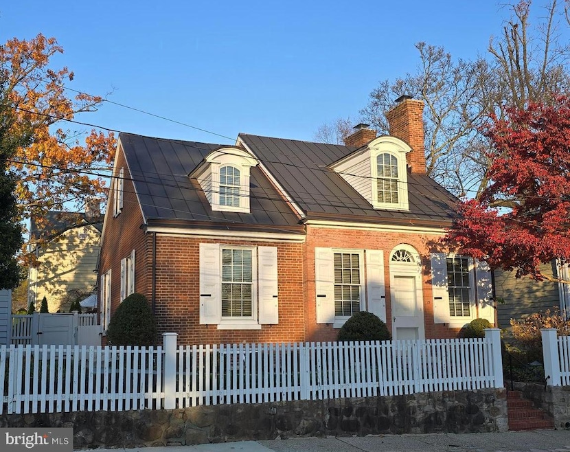
29 N Broad St Doylestown, PA 18901
Highlights
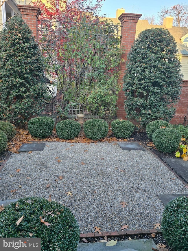
- Federal Architecture
- Traditional Floor Plan
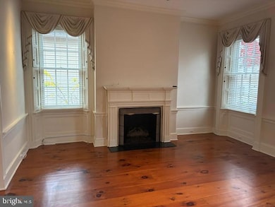
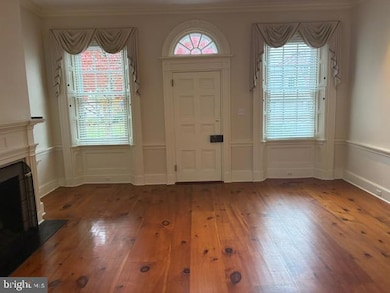
- Wood Flooring
- Linden El School Rated A
- Cathedral Ceiling
- 4-minute walk to Burpee Park
About This Home
This home is located at 29 N Broad St, Doylestown, PA 18901 and is currently priced at $3,250. This property was built in 1830. 29 N Broad St is a home located in Bucks County with nearby schools including Linden El School, Lenape Middle School, and Central Bucks High School-West.
Home Details
Home Type
- Single Family
Est. Annual Taxes
- $5,686
Year Built
- Built in 1830
Lot Details
- 5,673 Sq Ft Lot
- Lot Dimensions are 61.00 x 93.00
- West Facing Home
- Property is in excellent condition
- Property is zoned CR
Home Design
- Federal Architecture
- Traditional Architecture
- Entry on the 1st floor
- Plaster Walls
- Metal Roof
- Masonry
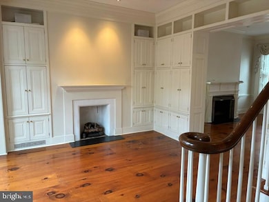
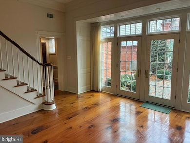
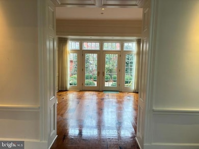
Interior Spaces
- 1,742 Sq Ft Home
- Property has 2 Levels
- Traditional Floor Plan
- Sound System
- Cathedral Ceiling
- 2 Fireplaces
- Wood Frame Window
- French Doors
- Formal Dining Room
Kitchen
- Eat-In Kitchen
- Range Hood
- Microwave
- Dishwasher
- Kitchen Island
- Disposal
Flooring
- Wood
- Tile or Brick
Bedrooms and Bathrooms
- En-Suite Bathroom
Laundry
- Dryer
- Washer
Finished Basement
- Basement Fills Entire Space Under The House
- Laundry in Basement
Parking
- Alley Access
- Paved Parking
Schools
- Linden Elementary School
- Lenape Middle School
- Central Bucks High School West
Utilities
- Forced Air Heating and Cooling System
- Natural Gas Water Heater
- Phone Available
- Cable TV Available
Listing and Financial Details
- Residential Lease
- Security Deposit $3,250
- Requires 2 Months of Rent Paid Up Front
- Tenant pays for cable TV, electricity, gas, heat, insurance, internet
- The owner pays for water, sewer
- No Smoking Allowed
- 12-Month Min and 24-Month Max Lease Term
- Available 11/15/25
- Assessor Parcel Number 08-009-040
Community Details
Overview
- No Home Owners Association
- $3,250 Other One-Time Fees
Pet Policy
- No Pets Allowed
Map
Source: Bright MLS
MLS Number: PABU2109186
APN: 08-009-040
Disclaimer: Certain information contained herein is derived from information provided by parties other than Homes.com. All information provided is deemed reliable, but is not guaranteed to be accurate and should be independently verified.
![]() The data relating to real estate for sale on this website appears in part through the BRIGHT Internet Data Exchange program, a voluntary cooperative exchange of property listing data between licensed real estate brokerage firms, and is provided by BRIGHT through a licensing agreement.
The data relating to real estate for sale on this website appears in part through the BRIGHT Internet Data Exchange program, a voluntary cooperative exchange of property listing data between licensed real estate brokerage firms, and is provided by BRIGHT through a licensing agreement.
Listing information is from various brokers who participate in the Bright MLS IDX program and not all listings may be visible on the site.
The property information being provided on or through the website is for the personal, non-commercial use of consumers and such information may not be used for any purpose other than to identify prospective properties consumers may be interested in purchasing.
Some properties which appear for sale on the website may no longer be available because they are for instance, under contract, sold or are no longer being offered for sale.
Property information displayed is deemed reliable but is not guaranteed.
Copyright 2025 Bright MLS, Inc.
- 1 Barnes Ct
- 155 E Oakland Ave
- 20 E Court St
- 69 E Oakland Ave
- 146 E Court St
- 146 N Church St
- 110 E Ashland St
- 226 N Main St
- 284 E Court St
- 37 N Clinton St
- 339 E Ashland St
- 236 Green St
- 121 Cottage St
- 0 000 Rd E
- 130 N Clinton St
- 418 North St
- 89 Homestead Dr
- 195 Lafayette St
- 466 Linden Ave
- 505 E State St
- 112 E State St Unit 6
- 44 E Court St Unit 2ND FLOOR
- 53 N Church St
- 50 N Main St Unit 302
- 22 N Main St Unit 3
- 263 N Main St
- 76 S Hamilton St
- 120 Green St
- 21 S Clinton St Unit 1
- 21 S Clinton St Unit 2
- 37 N Clinton St Unit A
- 165 S Main St Unit 2ND FLOOR
- 97 Cottage St
- 182 W Court St Unit 180
- 355 North St
- 333 N Broad St
- 211 N West St Unit 211B
- 323 2ND FLOOR S Main St
- 555 N Broad St
- 303 W State St
