Estimated Value: $527,686 - $635,000
4
Beds
3
Baths
3,062
Sq Ft
$190/Sq Ft
Est. Value
About This Home
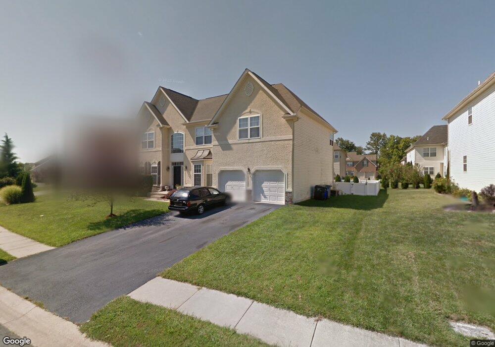
This home is located at 29 White Birch Blvd, Bear, DE 19701 and is currently estimated at $582,922, approximately $190 per square foot. 29 White Birch Blvd is a home located in New Castle County with nearby schools including William B. Keene Elementary School, Gauger-Cobbs Middle School, and Glasgow High School.
Ownership History
Date
Name
Owned For
Owner Type
Purchase Details
Closed on
Jun 28, 2002
Sold by
Sylvan Park Associates Llc
Bought by
Dunston Roland and Dunston Rosetta
Current Estimated Value
Home Financials for this Owner
Home Financials are based on the most recent Mortgage that was taken out on this home.
Original Mortgage
$240,650
Outstanding Balance
$102,812
Interest Rate
6.82%
Estimated Equity
$480,110
Create a Home Valuation Report for This Property
The Home Valuation Report is an in-depth analysis detailing your home's value as well as a comparison with similar homes in the area
Home Values in the Area
Average Home Value in this Area
Purchase History
| Date | Buyer | Sale Price | Title Company |
|---|---|---|---|
| Dunston Roland | $268,620 | Transnation Title Insurance |
Source: Public Records
Mortgage History
| Date | Status | Borrower | Loan Amount |
|---|---|---|---|
| Open | Dunston Roland | $240,650 |
Source: Public Records
Tax History
| Year | Tax Paid | Tax Assessment Tax Assessment Total Assessment is a certain percentage of the fair market value that is determined by local assessors to be the total taxable value of land and additions on the property. | Land | Improvement |
|---|---|---|---|---|
| 2024 | $4,856 | $110,500 | $12,900 | $97,600 |
| 2023 | $4,729 | $110,500 | $12,900 | $97,600 |
| 2022 | $4,696 | $110,500 | $12,900 | $97,600 |
| 2021 | $4,596 | $110,500 | $12,900 | $97,600 |
| 2020 | $4,469 | $110,500 | $12,900 | $97,600 |
| 2019 | $4,233 | $110,500 | $12,900 | $97,600 |
| 2018 | $3,875 | $110,500 | $12,900 | $97,600 |
| 2017 | $3,742 | $110,500 | $12,900 | $97,600 |
| 2016 | $3,713 | $110,500 | $12,900 | $97,600 |
| 2015 | $3,395 | $110,500 | $12,900 | $97,600 |
| 2014 | $3,397 | $110,500 | $12,900 | $97,600 |
Source: Public Records
Map
Nearby Homes
- 688 Corsica Ave
- 250 Palermo Dr
- 221 Vercelli Dr
- 840 Sabina Cir
- 3209 Wrangle Hill Rd
- 3211 Wrangle Hill Rd
- 3213 Wrangle Hill Rd
- 235 Cheyenne Dr
- 425 E Red Lion Dr
- 465 Granger Dr
- 479 Granger Dr
- 1791 Pulaski Hwy
- 204 Skeet Cir W
- 416 Ranee Loop Unit 96
- 622 Clifton Dr
- 8 Vincent Ct Unit 43
- 411 Pheasant Cir
- 45 Longleaf Ln
- 115 Whitburn Place
- 616 Clifton Dr
- 31 White Birch Blvd
- 27 White Birch Blvd
- 9 Crabapple Dr
- 11 Crabapple Dr
- 30 White Birch Blvd
- Lot 1 Old Porter Rd
- 00 Observatory Dr Unit CARTIE
- 00 Hubble Ave Unit MAGELL
- 00 Shepard Ave Unit CORONA
- 0 Shepard Ave Unit CARTIE 1006935580
- 0001 Olmsted Dr
- 00000 Meridian Blvd
- 0A Hubble Ave Unit MAGELL
- 0A Observatory Dr Unit CORONA
- 00A Observatory Dr Unit CARTIE
- 00A Hubble Ave Unit MARQUE
- HRS Bergenia Loop
- BHA Astilbe Ct
- 206 Remi Dr
- 000 Meridian Blvd
Your Personal Tour Guide
Ask me questions while you tour the home.