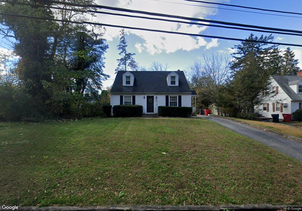
290 West Ave N Bridgeton, NJ 08302
Estimated Value: $222,000 - $306,000
3
Beds
1
Bath
1,344
Sq Ft
$200/Sq Ft
Est. Value
About This Home
This home is located at 290 West Ave N, Bridgeton, NJ 08302 and is currently estimated at $268,832, approximately $200 per square foot. 290 West Ave N is a home located in Cumberland County with nearby schools including Bridgeton High School, Bridgeton Christian School, and Immaculate Conception School.
Ownership History
Date
Name
Owned For
Owner Type
Purchase Details
Closed on
Dec 17, 2018
Sold by
Us Bank Na Tr
Bought by
Sanders Tenyatta L
Current Estimated Value
Home Financials for this Owner
Home Financials are based on the most recent Mortgage that was taken out on this home.
Original Mortgage
$140,409
Outstanding Balance
$124,170
Interest Rate
4.99%
Mortgage Type
FHA
Estimated Equity
$144,662
Purchase Details
Closed on
May 31, 2016
Sold by
Sheriff Of Cumberland County
Bought by
Us Bank Na
Purchase Details
Closed on
Nov 30, 2005
Sold by
Vanmeter Troy P
Bought by
Hudson Ervin and Parker Deana
Home Financials for this Owner
Home Financials are based on the most recent Mortgage that was taken out on this home.
Original Mortgage
$147,250
Interest Rate
6.14%
Create a Home Valuation Report for This Property
The Home Valuation Report is an in-depth analysis detailing your home's value as well as a comparison with similar homes in the area
Home Values in the Area
Average Home Value in this Area
Purchase History
| Date | Buyer | Sale Price | Title Company |
|---|---|---|---|
| Sanders Tenyatta L | $143,000 | -- | |
| Us Bank Na | -- | None Available | |
| Hudson Ervin | $155,000 | -- |
Source: Public Records
Mortgage History
| Date | Status | Borrower | Loan Amount |
|---|---|---|---|
| Open | Sanders Tenyatta L | $140,409 | |
| Previous Owner | Hudson Ervin | $147,250 |
Source: Public Records
Tax History Compared to Growth
Tax History
| Year | Tax Paid | Tax Assessment Tax Assessment Total Assessment is a certain percentage of the fair market value that is determined by local assessors to be the total taxable value of land and additions on the property. | Land | Improvement |
|---|---|---|---|---|
| 2025 | $4,659 | $88,100 | $16,900 | $71,200 |
| 2024 | $4,659 | $88,100 | $16,900 | $71,200 |
| 2023 | $4,471 | $88,100 | $16,900 | $71,200 |
| 2022 | $4,430 | $88,100 | $16,900 | $71,200 |
| 2021 | $4,420 | $88,100 | $16,900 | $71,200 |
| 2020 | $4,391 | $88,100 | $16,900 | $71,200 |
| 2019 | $3,975 | $81,600 | $16,900 | $64,700 |
| 2018 | $3,800 | $81,600 | $16,900 | $64,700 |
| 2017 | $3,690 | $81,600 | $16,900 | $64,700 |
| 2016 | $3,580 | $81,600 | $16,900 | $64,700 |
| 2015 | $3,517 | $81,600 | $16,900 | $64,700 |
| 2014 | $4,113 | $72,600 | $7,900 | $64,700 |
Source: Public Records
Map
Nearby Homes
- 47 Westwood Ave
- 28 Osborn Ln
- 16 Field Stone Ct
- 195 Mary Elmer Dr
- 177 Elwell Terrace
- 68 Lakeside Dr
- 225 W Commerce St
- 395 W Broad St
- 0 Sewall Rd Unit NJCB2020490
- 38 Roselawn Ave
- 151 W Commerce St
- 252 W Park Dr
- 16 Kinkle Rd
- 7 Holly Ln
- 117 Grandview Dr
- 0 St Unit NJSA2014462
- 262 W Park Dr
- 43 Franklin Dr
- 26 Franklin Dr
- 14 1/2 Smith Dr
- 290 N West Ave
- 300 N West Ave
- 270 N West Ave
- 5 Woodcrest Ave
- 312 N West Ave
- 7 Northwest Dr
- 9 Woodcrest Ave
- 9 Northwest Dr
- 14 Northwest Dr
- 262 N West Ave
- 324 West Ave N
- 324 N West Ave
- 112 W Park Dr
- 13 Northwest Dr
- 18 Northwest Dr
- 14 Woodcrest Ave
- 116 W Park Dr
- 17 Woodcrest Ave
- 17 Northwest Dr
- 230 N West Ave