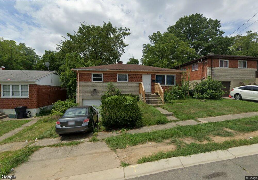
2901 Westknolls Ln Cincinnati, OH 45211
Westwood NeighborhoodEstimated Value: $132,000 - $178,000
3
Beds
2
Baths
1,602
Sq Ft
$100/Sq Ft
Est. Value
About This Home
This home is located at 2901 Westknolls Ln, Cincinnati, OH 45211 and is currently estimated at $160,376, approximately $100 per square foot. 2901 Westknolls Ln is a home located in Hamilton County with nearby schools including Western Hills High School, Gilbert A. Dater High School, and Robert A. Taft Information Technology High School.
Ownership History
Date
Name
Owned For
Owner Type
Purchase Details
Closed on
Aug 23, 2018
Sold by
Johnson Marvin L
Bought by
Lopez Lela Gisel Olivia
Current Estimated Value
Purchase Details
Closed on
Aug 19, 2014
Sold by
Johnson Marvin
Bought by
Oliva Pedro N
Home Financials for this Owner
Home Financials are based on the most recent Mortgage that was taken out on this home.
Original Mortgage
$5,000
Interest Rate
3.97%
Mortgage Type
Seller Take Back
Purchase Details
Closed on
May 5, 1993
Sold by
Savage Raymond A
Bought by
Johnson Marvin L
Create a Home Valuation Report for This Property
The Home Valuation Report is an in-depth analysis detailing your home's value as well as a comparison with similar homes in the area
Home Values in the Area
Average Home Value in this Area
Purchase History
| Date | Buyer | Sale Price | Title Company |
|---|---|---|---|
| Lopez Lela Gisel Olivia | $29,000 | None Available | |
| Oliva Pedro N | $5,000 | None Available | |
| Johnson Marvin L | $62,000 | -- |
Source: Public Records
Mortgage History
| Date | Status | Borrower | Loan Amount |
|---|---|---|---|
| Previous Owner | Oliva Pedro N | $5,000 |
Source: Public Records
Tax History Compared to Growth
Tax History
| Year | Tax Paid | Tax Assessment Tax Assessment Total Assessment is a certain percentage of the fair market value that is determined by local assessors to be the total taxable value of land and additions on the property. | Land | Improvement |
|---|---|---|---|---|
| 2024 | $2,106 | $35,088 | $5,474 | $29,614 |
| 2023 | $2,153 | $35,088 | $5,474 | $29,614 |
| 2022 | $1,681 | $24,518 | $4,781 | $19,737 |
| 2021 | $1,615 | $24,518 | $4,781 | $19,737 |
| 2020 | $1,662 | $24,518 | $4,781 | $19,737 |
| 2019 | $1,651 | $22,288 | $4,347 | $17,941 |
| 2018 | $1,654 | $22,288 | $4,347 | $17,941 |
| 2017 | $1,571 | $22,288 | $4,347 | $17,941 |
| 2016 | $1,410 | $19,706 | $6,038 | $13,668 |
| 2015 | $1,272 | $19,706 | $6,038 | $13,668 |
| 2014 | $1,281 | $19,706 | $6,038 | $13,668 |
| 2013 | $1,302 | $19,706 | $6,038 | $13,668 |
Source: Public Records
Map
Nearby Homes
- 2340 Harrison Ave
- 2266 Harrison Ave
- 2962 Aquadale Ln
- 2656 Fenton Ave
- 2722 Orland Ave Unit 2
- 2828 Ruberg Ave
- 2630 Cora Ave
- 2195 Harrison Ave
- 2504 Forthmann Place
- 3025 Mchenry Ave
- 2711 Baker Ave
- 3064 Mchenry Ave
- 2117 Saint Leo Place
- 3355 Cavanaugh Ave
- 3295 Fyffe Ave
- 2114 Saint Leo Place
- 3042 Percy Ave
- 3072 Worthington Ave
- 2082 Harrison Ave
- 2473 Wahl Terrace
- 2905 Westknolls Ln
- 2841 Westknolls Ln
- 2837 Westknolls Ln
- 2909 Westknolls Ln
- 2833 Westknolls Ln
- 2913 Westknolls Ln
- 2876 Orland Ave Unit 504
- 2732 Faber Ave
- 2875 Orland Ave
- 2917 Westknolls Ln
- 2872 Orland Ave
- 2740 Faber Ave
- 2829 Westknolls Ln
- 2871 Orland Ave
- 2912 Westknolls Ln
- 2832 Westknolls Ln
- 2744 Faber Ave
- 2921 Westknolls Ln
- 2916 Westknolls Ln
- 2867 Orland Ave