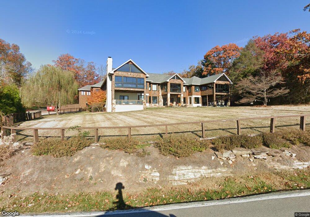
2903 E Brow Rd Signal Mountain, TN 37377
Walden NeighborhoodEstimated Value: $1,074,000 - $2,256,898
4
Beds
3
Baths
3,082
Sq Ft
$502/Sq Ft
Est. Value
About This Home
This home is located at 2903 E Brow Rd, Signal Mountain, TN 37377 and is currently estimated at $1,547,633, approximately $502 per square foot. 2903 E Brow Rd is a home located in Hamilton County with nearby schools including Nolan Elementary School, Signal Mountain Middle/High School, and Signal Mountain Christian School.
Ownership History
Date
Name
Owned For
Owner Type
Purchase Details
Closed on
Oct 31, 2011
Sold by
Suntrust Bank
Bought by
Scoggins Scott W and Scoggins Heather H
Current Estimated Value
Home Financials for this Owner
Home Financials are based on the most recent Mortgage that was taken out on this home.
Original Mortgage
$405,600
Outstanding Balance
$278,443
Interest Rate
4.16%
Mortgage Type
New Conventional
Estimated Equity
$1,269,190
Purchase Details
Closed on
Feb 13, 2006
Sold by
Suntrust Bank Chattanooga
Bought by
Suntrust Bank Chattanooga and Revocable Trust Agreement Of Lillian L C
Create a Home Valuation Report for This Property
The Home Valuation Report is an in-depth analysis detailing your home's value as well as a comparison with similar homes in the area
Home Values in the Area
Average Home Value in this Area
Purchase History
| Date | Buyer | Sale Price | Title Company |
|---|---|---|---|
| Scoggins Scott W | $507,000 | Cumberland Title & Guaranty | |
| Suntrust Bank Chattanooga | -- | None Available |
Source: Public Records
Mortgage History
| Date | Status | Borrower | Loan Amount |
|---|---|---|---|
| Open | Scoggins Scott W | $405,600 |
Source: Public Records
Tax History Compared to Growth
Tax History
| Year | Tax Paid | Tax Assessment Tax Assessment Total Assessment is a certain percentage of the fair market value that is determined by local assessors to be the total taxable value of land and additions on the property. | Land | Improvement |
|---|---|---|---|---|
| 2024 | $7,727 | $345,375 | $0 | $0 |
| 2023 | $9,563 | $345,375 | $0 | $0 |
| 2022 | $9,563 | $345,375 | $0 | $0 |
| 2021 | $8,523 | $307,825 | $0 | $0 |
| 2020 | $9,767 | $289,775 | $0 | $0 |
| 2019 | $9,477 | $289,775 | $0 | $0 |
| 2018 | $9,187 | $289,775 | $0 | $0 |
| 2017 | $9,129 | $289,775 | $0 | $0 |
| 2016 | $7,413 | $0 | $0 | $0 |
| 2015 | $6,493 | $232,075 | $0 | $0 |
| 2014 | $6,493 | $0 | $0 | $0 |
Source: Public Records
Map
Nearby Homes
- 3680 Wilson Ave
- 3002 Wilson Ave
- 2804 Taft Hwy
- 3612 Taft Hwy
- 914 Olsen Ave
- 5517 Abby Grace Loop
- 1702 James Blvd
- 848 Skyline Park Dr
- 0 Skyline Park Dr Unit 1525124
- 810 Younger Cir
- 837 Skyline Park Dr
- 5423 Mccahill Rd
- 4975 Browntown Rd
- 11 Saint Nicholas Way
- 0 Browntown Rd Unit 1519397
- 714 Berry Spring Path
- 10 Majestic Oaks Dr
- 25 Ridgerock Dr
- 1713 Timesville Rd
- 10 Acres Majestic Oaks Dr
- 2907 E Brow Rd
- 1 Bluffview Dr
- 2725 E Brow Rd
- 204 Sylvan City Dr
- 501 Bluffview Dr
- 207 Sylvan City Dr
- 112 Sylvan City Dr
- 2717 E Brow Rd
- 2915 E Brow Rd
- 210 Sylvan City Dr
- 114 Sylvan City Dr
- 213 Sylvan Dr
- 213 Sylvan City Dr
- 2709 E Brow Rd
- 214 Sylvan City Dr
- 215 Sylvan City Dr
- 201 Clegg St
- 3000 Spring Ave
- 3104 Spring Ave
- 0 Quail Hollow Cove Unit 688157