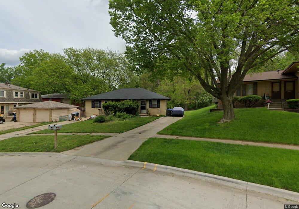
2905 67th St Des Moines, IA 50322
Merle Hay NeighborhoodEstimated Value: $264,000 - $274,122
4
Beds
2
Baths
1,408
Sq Ft
$191/Sq Ft
Est. Value
About This Home
This home is located at 2905 67th St, Des Moines, IA 50322 and is currently estimated at $269,031, approximately $191 per square foot. 2905 67th St is a home located in Polk County with nearby schools including Hillis Elementary School, Meredith Middle School, and Hoover High School.
Ownership History
Date
Name
Owned For
Owner Type
Purchase Details
Closed on
Mar 4, 2010
Sold by
Tracevskis Marite and Guzman Javier Jauregui
Bought by
Salmon Nicholas C and Salmon Amber L
Current Estimated Value
Home Financials for this Owner
Home Financials are based on the most recent Mortgage that was taken out on this home.
Original Mortgage
$50,000
Interest Rate
5%
Mortgage Type
Future Advance Clause Open End Mortgage
Purchase Details
Closed on
Oct 16, 1997
Sold by
Tracevskis Georg and Tracevskis Marite
Bought by
Tracevskis Marite
Create a Home Valuation Report for This Property
The Home Valuation Report is an in-depth analysis detailing your home's value as well as a comparison with similar homes in the area
Home Values in the Area
Average Home Value in this Area
Purchase History
Date | Buyer | Sale Price | Title Company |
---|---|---|---|
Salmon Nicholas C | $135,500 | Itc | |
Tracevskis Marite | -- | -- |
Source: Public Records
Mortgage History
Date | Status | Borrower | Loan Amount |
---|---|---|---|
Open | Salmon Nicholas C | $92,354 | |
Closed | Salmon Nicholas C | $90,000 | |
Closed | Salmon Nicholas C | $50,000 | |
Closed | Salmon Nicholas C | $95,200 | |
Previous Owner | Tracevskis Marite Z | $71,000 |
Source: Public Records
Tax History Compared to Growth
Tax History
Year | Tax Paid | Tax Assessment Tax Assessment Total Assessment is a certain percentage of the fair market value that is determined by local assessors to be the total taxable value of land and additions on the property. | Land | Improvement |
---|---|---|---|---|
2024 | $4,564 | $229,800 | $48,300 | $181,500 |
2023 | $4,538 | $229,800 | $48,300 | $181,500 |
2022 | $4,502 | $190,800 | $42,000 | $148,800 |
2021 | $4,388 | $190,800 | $42,000 | $148,800 |
2020 | $4,556 | $174,300 | $38,300 | $136,000 |
2019 | $4,268 | $174,300 | $38,300 | $136,000 |
2018 | $4,222 | $157,400 | $33,700 | $123,700 |
2017 | $3,826 | $157,400 | $33,700 | $123,700 |
2016 | $3,722 | $140,300 | $30,100 | $110,200 |
2015 | $3,722 | $140,300 | $30,100 | $110,200 |
2014 | $3,280 | $126,900 | $26,600 | $100,300 |
Source: Public Records
Map
Nearby Homes
- 3200 67th St
- 3200 64th St
- 6301 Sherrick Ave
- 2711 Westover Blvd
- 6700 Sheridan Ave
- 6916 Hopkins Rd
- 3020 62nd St
- 6400 Dawson Dr
- 6129 Boston Ave
- 7102 Beechwood Dr
- 2705 71st St
- 2721 61st St
- 6903 Oliver Smith Dr
- 2502 61st St
- 5820 Urbandale Ave
- 7019 Maryland Dr
- 7202 Beechwood Dr
- 3513 62nd St
- 5804 Snyder Ave
- 7103 Oliver Smith Dr
- 2905 67th St
- 2901 67th St
- 2835 67th St
- 6608 Urbandale Ave
- 2908 67th St
- 2924 67th St
- 6600 Urbandale Ave
- 2829 67th St
- 2900 Westover Blvd
- 6707 Sherrick Ave
- 6700 Sherrick Ave
- 6700 Sherrick Ave Unit 1
- 2920 Westover Blvd
- 2828 67th St
- 2828 & 2826 67th St
- 2904 Westover Blvd
- 6609 New York Cir
- 6613 New York Cir
- 2924 Westover Blvd
- 6605 New York Cir