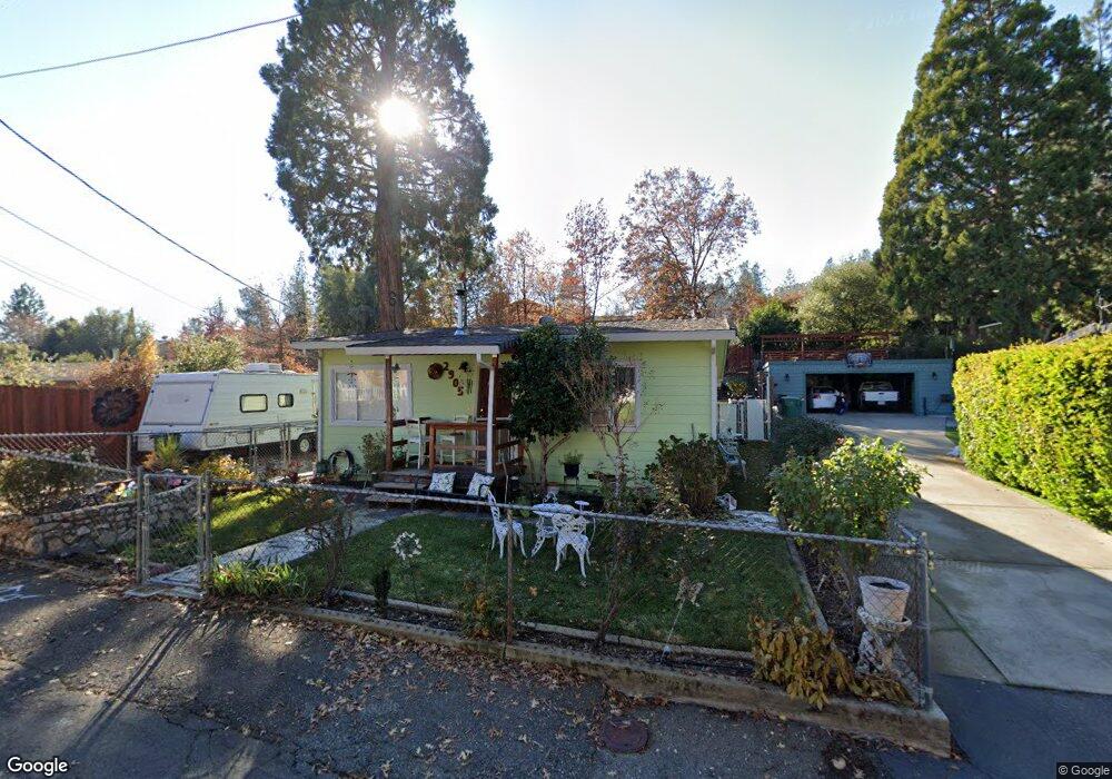
2905 Anderson Way Placerville, CA 95667
Estimated Value: $249,793 - $357,000
2
Beds
1
Bath
700
Sq Ft
$410/Sq Ft
Est. Value
About This Home
This home is located at 2905 Anderson Way, Placerville, CA 95667 and is currently estimated at $286,698, approximately $409 per square foot. 2905 Anderson Way is a home located in El Dorado County with nearby schools including El Dorado High School, Country Day Montessori, and El Dorado Adventist School.
Ownership History
Date
Name
Owned For
Owner Type
Purchase Details
Closed on
Oct 20, 2014
Sold by
Bannister Gloria D
Bought by
Bannister David M
Current Estimated Value
Purchase Details
Closed on
Dec 16, 2008
Sold by
Bannister Harry C and Bannister Gloria D
Bought by
Bannister Harry C and Bannister Gloria D
Purchase Details
Closed on
Sep 15, 1994
Sold by
Bannister Harry C and Bannister Gloria D
Bought by
Bannister Harry C and Bannister Gloria D
Create a Home Valuation Report for This Property
The Home Valuation Report is an in-depth analysis detailing your home's value as well as a comparison with similar homes in the area
Home Values in the Area
Average Home Value in this Area
Purchase History
| Date | Buyer | Sale Price | Title Company |
|---|---|---|---|
| Bannister David M | -- | None Available | |
| Bannister Gloria D | -- | None Available | |
| Bannister Harry C | -- | None Available | |
| Bannister Harry C | -- | -- |
Source: Public Records
Tax History Compared to Growth
Tax History
| Year | Tax Paid | Tax Assessment Tax Assessment Total Assessment is a certain percentage of the fair market value that is determined by local assessors to be the total taxable value of land and additions on the property. | Land | Improvement |
|---|---|---|---|---|
| 2025 | $217 | $23,944 | $5,969 | $17,975 |
| 2024 | $217 | $23,475 | $5,852 | $17,623 |
| 2023 | $214 | $23,016 | $5,738 | $17,278 |
| 2022 | $210 | $22,566 | $5,626 | $16,940 |
| 2021 | $207 | $22,124 | $5,516 | $16,608 |
| 2020 | $203 | $21,898 | $5,460 | $16,438 |
| 2019 | $200 | $21,469 | $5,353 | $16,116 |
| 2018 | $194 | $21,049 | $5,249 | $15,800 |
| 2017 | $190 | $20,638 | $5,147 | $15,491 |
| 2016 | $187 | $20,235 | $5,047 | $15,188 |
| 2015 | $178 | $19,933 | $4,972 | $14,961 |
| 2014 | $178 | $19,545 | $4,876 | $14,669 |
Source: Public Records
Map
Nearby Homes
- 2940 Anderson Way
- 2921 Miller Way
- 2977 Mosquito Rd
- 1017 Utah Dr
- 1001 Utah Dr
- 1015 Utah Dr
- 3022 Constellation Ave
- 1011 Utah Dr
- Plan 2 at Sutter’s Ridge
- 1284 Roxie Way
- 2771 Morrene Dr
- 678 Main St
- 2896 Clay St
- 2689 Morrene Dr
- 0 Lincoln Alley
- 944 Crawford Drift Ct
- 945 Crawford Drift Ct
- 0 Trails End Dr Unit 225117516
- 2-Acres Homestead Dr
- 3 Acres
- 2911 Anderson Way
- 2901 Anderson Way
- 2915 Anderson Way
- 2897 Anderson Way
- 2811 Pennsylvania Ct
- 2904 Anderson Way
- 2816 Pennsylvania Ct
- 2893 Anderson Way
- 2676 Clay St
- 2919 Anderson Way
- 2910 Anderson Way
- 2869 Willow St
- 0 Anderson Way Unit 221020619
- 0 Anderson Way
- 2914 Anderson Way
- 2810 Pennsylvania Ct
- 2803 Pennsylvania Ct
- 2864 Willow St
- 2670 Clay St
- 1113 Anderson Ct