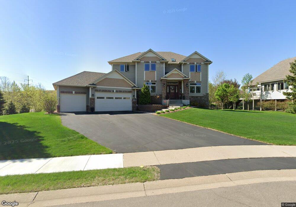
2909 Butternut Dr Chaska, MN 55318
Estimated Value: $657,000 - $790,000
5
Beds
4
Baths
2,938
Sq Ft
$244/Sq Ft
Est. Value
About This Home
This home is located at 2909 Butternut Dr, Chaska, MN 55318 and is currently estimated at $716,741, approximately $243 per square foot. 2909 Butternut Dr is a home located in Carver County with nearby schools including Jonathan Elementary School, Chaska Middle School East, and Chaska High School.
Ownership History
Date
Name
Owned For
Owner Type
Purchase Details
Closed on
Apr 5, 2019
Sold by
Mehta Rajkumar and Mehta Elyse Sowyim Yonog
Bought by
Dunkelberger Kip L and Dunkelberger Amy J
Current Estimated Value
Home Financials for this Owner
Home Financials are based on the most recent Mortgage that was taken out on this home.
Original Mortgage
$432,000
Outstanding Balance
$379,805
Interest Rate
4.3%
Mortgage Type
New Conventional
Estimated Equity
$336,936
Purchase Details
Closed on
Jul 27, 2005
Sold by
Morlock Bobbie D and Morlock Nita
Bought by
Mehta Rajkumar and Yim Yong Sow
Purchase Details
Closed on
Oct 4, 2002
Sold by
Arridson Michael G and Arridson Carol F
Bought by
Morlock Bobbie D
Purchase Details
Closed on
Apr 2, 2001
Sold by
Thorp Paul A and Thorp Ann L
Bought by
Arvidson Michael G
Purchase Details
Closed on
Aug 19, 1999
Sold by
City Of Chaska
Bought by
Thorp Paul A and Thorp Ann L
Create a Home Valuation Report for This Property
The Home Valuation Report is an in-depth analysis detailing your home's value as well as a comparison with similar homes in the area
Home Values in the Area
Average Home Value in this Area
Purchase History
| Date | Buyer | Sale Price | Title Company |
|---|---|---|---|
| Dunkelberger Kip L | $540,000 | Edina Realty Title | |
| Mehta Rajkumar | $547,000 | -- | |
| Morlock Bobbie D | $93,000 | -- | |
| Arvidson Michael G | $75,000 | -- | |
| Thorp Paul A | $237,905 | -- |
Source: Public Records
Mortgage History
| Date | Status | Borrower | Loan Amount |
|---|---|---|---|
| Open | Dunkelberger Kip L | $432,000 |
Source: Public Records
Tax History
| Year | Tax Paid | Tax Assessment Tax Assessment Total Assessment is a certain percentage of the fair market value that is determined by local assessors to be the total taxable value of land and additions on the property. | Land | Improvement |
|---|---|---|---|---|
| 2025 | $8,224 | $673,200 | $166,300 | $506,900 |
| 2024 | $7,576 | $647,900 | $166,300 | $481,600 |
| 2023 | $7,122 | $616,200 | $166,300 | $449,900 |
| 2022 | $7,092 | $606,900 | $157,400 | $449,500 |
| 2021 | $6,826 | $548,800 | $130,700 | $418,100 |
| 2020 | $7,250 | $573,800 | $133,400 | $440,400 |
| 2019 | $6,960 | $533,100 | $127,000 | $406,100 |
| 2018 | $36 | $533,100 | $127,000 | $406,100 |
| 2017 | $6,698 | $525,900 | $115,500 | $410,400 |
| 2016 | $7,608 | $541,200 | $0 | $0 |
| 2015 | $6,848 | $525,400 | $0 | $0 |
| 2014 | $6,848 | $473,000 | $0 | $0 |
Source: Public Records
Map
Nearby Homes
- 2888 Forest Ridge
- 9580 Madison Dr Unit 4
- 9575 Jefferson Dr Unit 1
- 9620 Washington Blvd Unit 1
- 1840 Freedom Ln Unit 104
- 1846 Plymouth Ln Unit 101
- 1953 Commonwealth Blvd Unit 3
- 1949 Commonwealth Blvd Unit 2
- 2890 Autumn Woods Dr
- 1968 Lincoln Ln
- 9534 Roosevelt Dr
- 2658 Shadow Ln
- 1157 Ridge Bluff Ct
- 1460 Jersey Way
- 1570 Avienda Ln
- 1500 Avienda Pkwy
- 9155 Mills Dr
- 9115 Mills Dr
- 3 Birdie Ln
- 9085 Mills Dr
- 2907 Butternut Dr
- 2910 Butternut Dr
- 2908 Butternut Dr
- 2905 Butternut Dr
- 2900 Forest Ridge
- 2899 Forest Ridge
- 2901 Forest Ridge
- 9695 Independence Cir Unit 3
- 9695 Independence Cir
- 9695 Independence Cir Unit 1
- 9695 Independence Cir Unit 2
- 9685 Independence Cir Unit 1
- 9685 Independence Cir Unit 2
- 9685 Independence Cir Unit 4
- 9685 Independence Cir Unit 3
- 9685 Independence Cir Unit 5
- 9685 Independence Cir Unit 6
- 2898 Forest Ridge
- 2912 Ironwood Blvd
- 2918 Ironwood Blvd
Your Personal Tour Guide
Ask me questions while you tour the home.