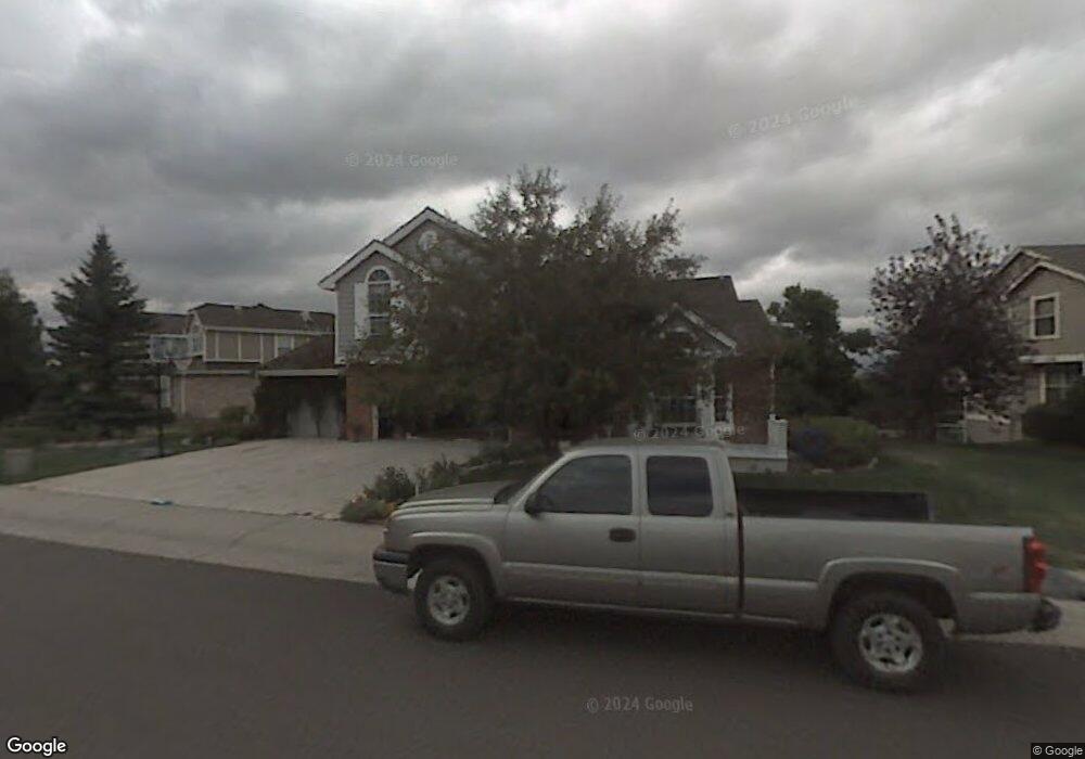
291 Clare Dr Castle Pines, CO 80108
Estimated Value: $836,000 - $946,000
4
Beds
4
Baths
2,909
Sq Ft
$303/Sq Ft
Est. Value
About This Home
This home is located at 291 Clare Dr, Castle Pines, CO 80108 and is currently estimated at $881,151, approximately $302 per square foot. 291 Clare Dr is a home located in Douglas County with nearby schools including Buffalo Ridge Elementary School, Rocky Heights Middle School, and Rock Canyon High School.
Ownership History
Date
Name
Owned For
Owner Type
Purchase Details
Closed on
Apr 7, 2025
Sold by
Burd John D
Bought by
Burdsnest Trust
Current Estimated Value
Purchase Details
Closed on
Mar 12, 2015
Sold by
Burd Ii John D and Burd Cynthia A
Bought by
Burd Ii John D
Purchase Details
Closed on
Sep 27, 2001
Sold by
Allwein Edward F and Constantine Linda M
Bought by
Burd Ii John D and Burd Cynthia A
Home Financials for this Owner
Home Financials are based on the most recent Mortgage that was taken out on this home.
Original Mortgage
$100,000
Interest Rate
6.88%
Purchase Details
Closed on
Jan 2, 1998
Sold by
Pendleton Paul T and Smith Michelle R
Bought by
Allwein Edward F and Constantine Linda M
Home Financials for this Owner
Home Financials are based on the most recent Mortgage that was taken out on this home.
Original Mortgage
$212,000
Interest Rate
7%
Purchase Details
Closed on
Oct 24, 1990
Sold by
Soulsby Donald R and Soulsby Karen Ann
Bought by
Pendleton Paul T and Pendleton Michelle R
Purchase Details
Closed on
Aug 8, 1989
Sold by
Writer Corp
Bought by
Soulsby Donald R and Soulsby Karen Ann
Create a Home Valuation Report for This Property
The Home Valuation Report is an in-depth analysis detailing your home's value as well as a comparison with similar homes in the area
Home Values in the Area
Average Home Value in this Area
Purchase History
| Date | Buyer | Sale Price | Title Company |
|---|---|---|---|
| Burdsnest Trust | -- | None Listed On Document | |
| Burd Ii John D | -- | None Available | |
| Burd Ii John D | $314,000 | -- | |
| Allwein Edward F | $265,000 | North American Title | |
| Pendleton Paul T | $189,000 | -- | |
| Soulsby Donald R | $204,000 | -- |
Source: Public Records
Mortgage History
| Date | Status | Borrower | Loan Amount |
|---|---|---|---|
| Previous Owner | Burd Ii John D | $100,000 | |
| Previous Owner | Allwein Edward F | $212,000 |
Source: Public Records
Tax History Compared to Growth
Tax History
| Year | Tax Paid | Tax Assessment Tax Assessment Total Assessment is a certain percentage of the fair market value that is determined by local assessors to be the total taxable value of land and additions on the property. | Land | Improvement |
|---|---|---|---|---|
| 2024 | $5,487 | $65,840 | $11,330 | $54,510 |
| 2023 | $5,539 | $65,840 | $11,330 | $54,510 |
| 2022 | $3,534 | $43,590 | $8,090 | $35,500 |
| 2021 | $3,673 | $43,590 | $8,090 | $35,500 |
| 2020 | $3,632 | $43,110 | $7,330 | $35,780 |
| 2019 | $3,643 | $43,110 | $7,330 | $35,780 |
| 2018 | $3,118 | $37,530 | $5,810 | $31,720 |
| 2017 | $2,929 | $37,530 | $5,810 | $31,720 |
| 2016 | $3,156 | $36,680 | $6,960 | $29,720 |
| 2015 | $3,508 | $36,680 | $6,960 | $29,720 |
| 2014 | $1,810 | $28,260 | $6,410 | $21,850 |
Source: Public Records
Map
Nearby Homes
- 7207 Shoreham Dr
- 7218 Campden Place
- 7412 Berkeley Ct
- 7263 Wembley Place
- 7445 Shoreham Place
- 18 Brixham Ct
- 577 Clarendon Loop
- 1250 Bridgefield Rd
- 1249 Bridgefield Rd
- 7369 Norfolk Place
- 6810 Brendon Place
- 252 Huntley Ct
- 7271 Brixham Cir
- 7083 Turweston Ln
- 750 Deer Clover Cir
- 7350 Brixham Cir
- 166 Green Fee Cir
- 811 Deer Clover Cir
- 527 Stonemont Dr
- 7153 Othello St