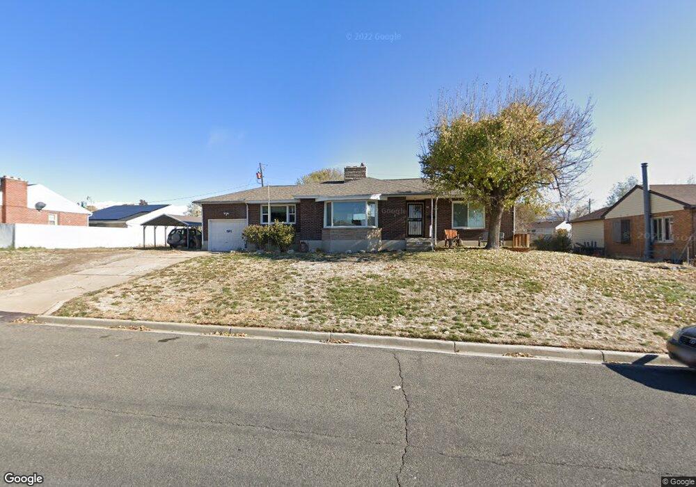
291 S 750 E Clearfield, UT 84015
Estimated Value: $412,000 - $441,215
5
Beds
2
Baths
2,718
Sq Ft
$157/Sq Ft
Est. Value
About This Home
This home is located at 291 S 750 E, Clearfield, UT 84015 and is currently estimated at $426,554, approximately $156 per square foot. 291 S 750 E is a home located in Davis County with nearby schools including South Clearfield Elementary School, North Davis Junior High School, and Clearfield High School.
Ownership History
Date
Name
Owned For
Owner Type
Purchase Details
Closed on
Mar 18, 2020
Sold by
Fisher Cindy S
Bought by
Anderson Thomas
Current Estimated Value
Home Financials for this Owner
Home Financials are based on the most recent Mortgage that was taken out on this home.
Original Mortgage
$252,200
Outstanding Balance
$222,933
Interest Rate
3.4%
Mortgage Type
New Conventional
Estimated Equity
$203,621
Purchase Details
Closed on
Jun 11, 1999
Sold by
Morishita Doug and Hamada Sheral
Bought by
Schell Robert J and Schell Joanne A
Home Financials for this Owner
Home Financials are based on the most recent Mortgage that was taken out on this home.
Original Mortgage
$103,950
Interest Rate
7.01%
Mortgage Type
Purchase Money Mortgage
Purchase Details
Closed on
Oct 7, 1997
Sold by
Morishita Mae and Morishita Doug
Bought by
Morishita Doug and Hamada Sheral
Create a Home Valuation Report for This Property
The Home Valuation Report is an in-depth analysis detailing your home's value as well as a comparison with similar homes in the area
Home Values in the Area
Average Home Value in this Area
Purchase History
| Date | Buyer | Sale Price | Title Company |
|---|---|---|---|
| Anderson Thomas | -- | Title Guarantee Layt | |
| Schell Robert J | -- | Associated Title Company | |
| Morishita Doug | -- | -- |
Source: Public Records
Mortgage History
| Date | Status | Borrower | Loan Amount |
|---|---|---|---|
| Open | Anderson Thomas | $252,200 | |
| Previous Owner | Schell Robert J | $103,950 |
Source: Public Records
Tax History
| Year | Tax Paid | Tax Assessment Tax Assessment Total Assessment is a certain percentage of the fair market value that is determined by local assessors to be the total taxable value of land and additions on the property. | Land | Improvement |
|---|---|---|---|---|
| 2025 | $2,559 | $229,350 | $88,743 | $140,607 |
| 2024 | $2,480 | $223,850 | $84,711 | $139,139 |
| 2023 | $2,312 | $383,000 | $133,767 | $249,233 |
| 2022 | $2,498 | $223,850 | $75,021 | $148,829 |
| 2021 | $2,068 | $280,000 | $89,018 | $190,982 |
Source: Public Records
Map
Nearby Homes
Your Personal Tour Guide
Ask me questions while you tour the home.