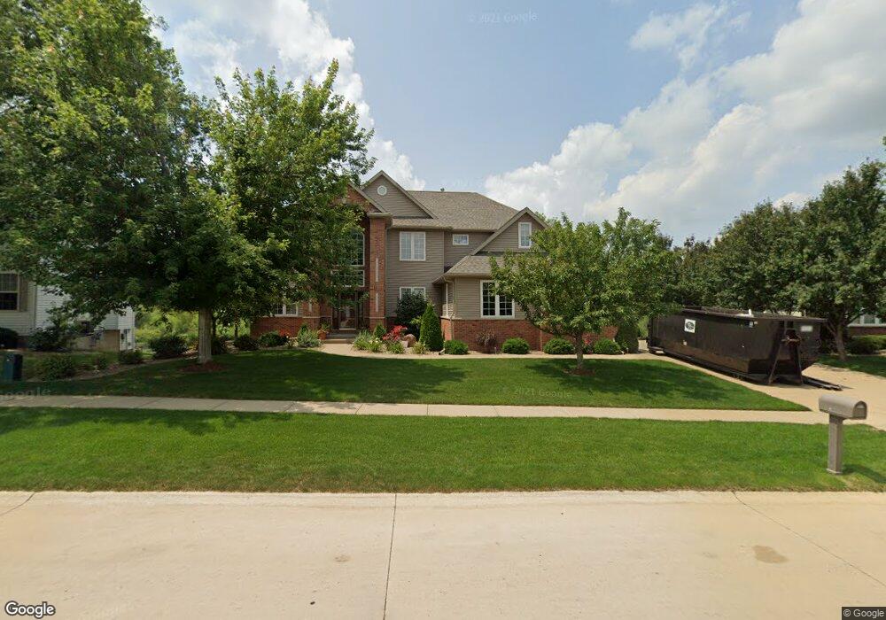
2910 Newcastle Rd Marion, IA 52302
Estimated Value: $557,000 - $714,000
5
Beds
7
Baths
3,091
Sq Ft
$214/Sq Ft
Est. Value
About This Home
This home is located at 2910 Newcastle Rd, Marion, IA 52302 and is currently estimated at $660,919, approximately $213 per square foot. 2910 Newcastle Rd is a home located in Linn County with nearby schools including Echo Hill Elementary School, Oak Ridge School, and Linn-Mar High School.
Ownership History
Date
Name
Owned For
Owner Type
Purchase Details
Closed on
May 22, 2005
Sold by
Cooper Tony A and Cooper Donna S
Bought by
Helling Larry Joseph and Helling Janice Marie
Current Estimated Value
Home Financials for this Owner
Home Financials are based on the most recent Mortgage that was taken out on this home.
Original Mortgage
$404,000
Interest Rate
5.5%
Mortgage Type
Fannie Mae Freddie Mac
Purchase Details
Closed on
Apr 17, 2002
Sold by
Bbak Investments Ltd
Bought by
Cooper Tony A and Cooper Donna S
Create a Home Valuation Report for This Property
The Home Valuation Report is an in-depth analysis detailing your home's value as well as a comparison with similar homes in the area
Home Values in the Area
Average Home Value in this Area
Purchase History
| Date | Buyer | Sale Price | Title Company |
|---|---|---|---|
| Helling Larry Joseph | $504,500 | -- | |
| Cooper Tony A | $18,000 | -- |
Source: Public Records
Mortgage History
| Date | Status | Borrower | Loan Amount |
|---|---|---|---|
| Previous Owner | Helling Larry Joseph | $404,000 |
Source: Public Records
Tax History Compared to Growth
Tax History
| Year | Tax Paid | Tax Assessment Tax Assessment Total Assessment is a certain percentage of the fair market value that is determined by local assessors to be the total taxable value of land and additions on the property. | Land | Improvement |
|---|---|---|---|---|
| 2025 | $12,736 | $726,100 | $54,800 | $671,300 |
| 2024 | $10,192 | $694,800 | $54,800 | $640,000 |
| 2023 | $10,192 | $694,800 | $54,800 | $640,000 |
| 2022 | $9,714 | $468,200 | $54,800 | $413,400 |
| 2021 | $10,936 | $468,200 | $54,800 | $413,400 |
| 2020 | $10,936 | $493,900 | $54,800 | $439,100 |
| 2019 | $10,044 | $453,800 | $54,800 | $399,000 |
| 2018 | $9,652 | $453,800 | $54,800 | $399,000 |
| 2017 | $9,586 | $444,200 | $54,800 | $389,400 |
| 2016 | $9,586 | $444,200 | $54,800 | $389,400 |
| 2015 | $9,551 | $444,200 | $54,800 | $389,400 |
| 2014 | $9,364 | $444,200 | $54,800 | $389,400 |
| 2013 | $8,940 | $444,200 | $54,800 | $389,400 |
Source: Public Records
Map
Nearby Homes
- 1112 Portsmith Cir
- 7104 Brentwood Dr NE
- 1000 Hampshire Cir
- 980 Hampshire Cir
- 960 Hampshire Cir
- 948 Hampshire Cir
- 916 Hampshire Cir
- 932 Prescott Ln
- 884 Hampshire Cir
- 862 Hampshire Cir
- 819 Hampshire Cir
- 820 Hampshire Cir
- 735 Buckingham Place
- 1150 Bedford Ct
- 786 Hampshire Cir
- 2654 Mulberry Ct
- 750 Hampshire Dr
- 764 Hampshire Cir
- 342 Cambridge Dr NE
- 2140 Newcastle Rd
- 2870 Newcastle Rd
- 2950 Newcastle Rd
- 2905 Newcastle Rd
- 2840 Newcastle Rd
- 2945 Newcastle Rd
- 2980 Newcastle Rd
- 213 Newcastle Rd
- 2985 Newcastle Rd
- 2825 Newcastle Rd
- 2820 Newcastle Rd
- 3000 Newcastle Rd
- 1101 Portsmith Cir
- 1179 Portsmith Cir
- 1193 Portsmith Cir
- 2805 Newcastle Rd
- 3005 Newcastle Rd
- 2790 Newcastle Rd
- 1150 Hampshire Dr
- 3008 Hampshire Cir
- 1145 Portsmith Cir