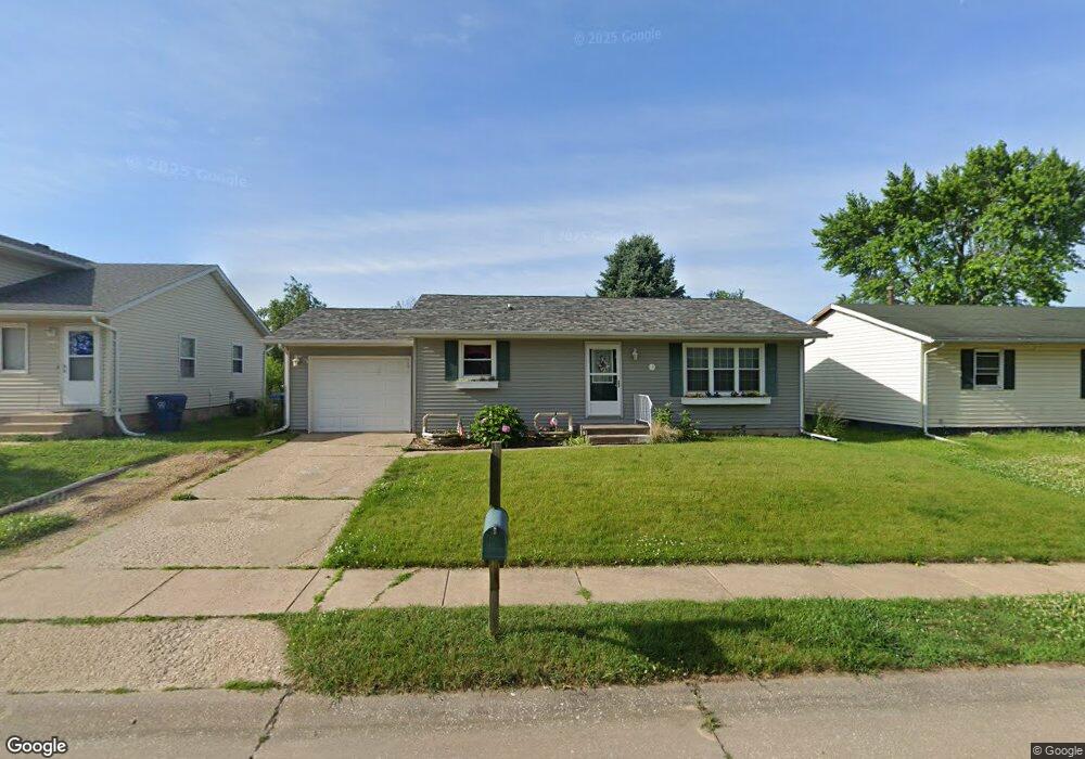
2911 W 66th St Davenport, IA 52806
North Side NeighborhoodEstimated Value: $176,406 - $212,000
3
Beds
2
Baths
1,008
Sq Ft
$188/Sq Ft
Est. Value
About This Home
This home is located at 2911 W 66th St, Davenport, IA 52806 and is currently estimated at $189,352, approximately $187 per square foot. 2911 W 66th St is a home located in Scott County with nearby schools including Cumberland Hall School, Academy Of Continuing Education, and Wood Intermediate School.
Ownership History
Date
Name
Owned For
Owner Type
Purchase Details
Closed on
Jul 25, 2012
Sold by
Mccoy Steven P and Mccoy Leslie A
Bought by
Mccoy Steven P and Mccoy Leslie A
Current Estimated Value
Home Financials for this Owner
Home Financials are based on the most recent Mortgage that was taken out on this home.
Original Mortgage
$68,700
Outstanding Balance
$10,593
Interest Rate
3.73%
Mortgage Type
New Conventional
Estimated Equity
$178,759
Purchase Details
Closed on
Jan 29, 2007
Sold by
Stirk John Mason and Stirk Kathleen L
Bought by
Mccoy Steven P
Create a Home Valuation Report for This Property
The Home Valuation Report is an in-depth analysis detailing your home's value as well as a comparison with similar homes in the area
Home Values in the Area
Average Home Value in this Area
Purchase History
| Date | Buyer | Sale Price | Title Company |
|---|---|---|---|
| Mccoy Steven P | -- | None Available | |
| Mccoy Steven P | $86,500 | None Available |
Source: Public Records
Mortgage History
| Date | Status | Borrower | Loan Amount |
|---|---|---|---|
| Open | Mccoy Steven P | $68,700 |
Source: Public Records
Tax History Compared to Growth
Tax History
| Year | Tax Paid | Tax Assessment Tax Assessment Total Assessment is a certain percentage of the fair market value that is determined by local assessors to be the total taxable value of land and additions on the property. | Land | Improvement |
|---|---|---|---|---|
| 2025 | $2,504 | $182,500 | $31,370 | $151,130 |
| 2024 | $2,556 | $164,030 | $31,370 | $132,660 |
| 2023 | $2,838 | $164,030 | $31,370 | $132,660 |
| 2022 | $2,764 | $141,730 | $24,240 | $117,490 |
| 2021 | $2,764 | $137,720 | $24,240 | $113,480 |
| 2020 | $2,582 | $127,680 | $24,240 | $103,440 |
| 2019 | $2,494 | $119,640 | $24,240 | $95,400 |
| 2018 | $2,436 | $119,640 | $24,240 | $95,400 |
| 2017 | $2,412 | $119,640 | $24,240 | $95,400 |
| 2016 | $2,320 | $114,620 | $0 | $0 |
| 2015 | $2,320 | $114,090 | $0 | $0 |
| 2014 | $2,340 | $110,070 | $0 | $0 |
| 2013 | $2,208 | $0 | $0 | $0 |
| 2012 | -- | $87,390 | $24,550 | $62,840 |
Source: Public Records
Map
Nearby Homes
- 2822 High Point Dr
- 2714 W 66th St
- 6050 Hillandale Rd
- 2508 W 60th Place
- 2514 W 60th St
- 5904 Hillandale Rd
- 6504 Cedar St
- 5824 Hillandale Rd
- 2434 W 59th St
- 5812 Hillandale Rd
- 2110 W 68th St
- Lot 55 Franklin
- 000 W 73rd St
- 2012 W 68th St
- 5556 N Thornwood Ave
- 7402 N Pine St
- Lot 65 W 66th St
- 7319 Volquardsen Ave
- 000 Pacific St
- 2620 W 54th St