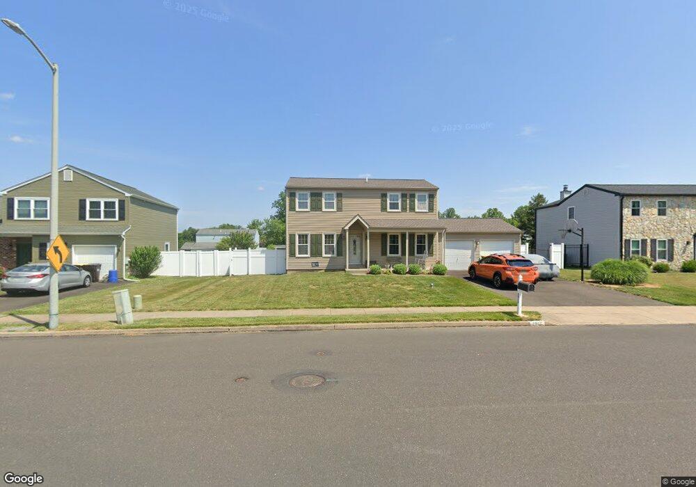
2912 Wexford Rd Bensalem, PA 19020
Neshaminy Valley NeighborhoodEstimated Value: $519,760 - $558,000
4
Beds
3
Baths
1,884
Sq Ft
$287/Sq Ft
Est. Value
About This Home
This home is located at 2912 Wexford Rd, Bensalem, PA 19020 and is currently estimated at $540,440, approximately $286 per square foot. 2912 Wexford Rd is a home located in Bucks County with nearby schools including Valley Elementary School, St. Ephrem School, and Bensalem Baptist School.
Ownership History
Date
Name
Owned For
Owner Type
Purchase Details
Closed on
Oct 22, 2020
Sold by
Greway Michael R and Greway Marie E
Bought by
Greway Michael R
Current Estimated Value
Purchase Details
Closed on
Mar 6, 1985
Sold by
Neshaminy Twins Corp
Bought by
Greway Michael R and Greway Marie E
Create a Home Valuation Report for This Property
The Home Valuation Report is an in-depth analysis detailing your home's value as well as a comparison with similar homes in the area
Home Values in the Area
Average Home Value in this Area
Purchase History
| Date | Buyer | Sale Price | Title Company |
|---|---|---|---|
| Greway Michael R | -- | None Available | |
| Greway Michael R | $92,400 | -- |
Source: Public Records
Tax History Compared to Growth
Tax History
| Year | Tax Paid | Tax Assessment Tax Assessment Total Assessment is a certain percentage of the fair market value that is determined by local assessors to be the total taxable value of land and additions on the property. | Land | Improvement |
|---|---|---|---|---|
| 2025 | $6,228 | $28,530 | $7,240 | $21,290 |
| 2024 | $6,228 | $28,530 | $7,240 | $21,290 |
| 2023 | $6,052 | $28,530 | $7,240 | $21,290 |
| 2022 | $6,017 | $28,530 | $7,240 | $21,290 |
| 2021 | $6,017 | $28,530 | $7,240 | $21,290 |
| 2020 | $5,957 | $28,530 | $7,240 | $21,290 |
| 2019 | $5,824 | $28,530 | $7,240 | $21,290 |
| 2018 | $5,689 | $28,530 | $7,240 | $21,290 |
| 2017 | $5,653 | $28,530 | $7,240 | $21,290 |
| 2016 | $5,653 | $28,530 | $7,240 | $21,290 |
| 2015 | -- | $28,530 | $7,240 | $21,290 |
| 2014 | -- | $28,530 | $7,240 | $21,290 |
Source: Public Records
Map
Nearby Homes
- 5762 Prescott Ct
- 6501 Saratoga Turn
- 3200 Ellington Ct
- 3255 Independence Ct
- 6257 Nathan Hale Ct
- 6369 Powder Horn Ct
- 2493 Barnsleigh Dr
- 4525 Winding Brook Dr Unit 4525
- 6561 Neshaminy Valley Dr
- 3162 Sheppard Rd
- 927 Bellevue Ave
- 1838 Sheri Rd
- 4902 Oxford Ct
- 4828 Oxford Ct
- 5813 Edge Ave
- 3021 Claridge Rd
- 5178 Neshaminy Blvd
- 223 Saddlebrook Dr
- 225 Saddlebrook Dr
- 440 Dehaven Ave
- 2906 Wexford Rd
- 2918 Wexford Rd
- 2913 Meredith Place
- 2900 Wexford Rd
- 2907 Meredith Place
- 2919 Meredith Place
- 2924 Wexford Rd
- 2901 Meredith Place
- 2925 Meredith Place
- 2570 Cannonball Ct
- 2571 Cannonball Ct
- 2930 Wexford Rd
- 2933 Kinsman Ct
- 5777 Cavalier Ct
- 2937 Kinsman Ct
- 2935 Kinsman Ct
- 2939 Kinsman Ct
- 2931 Meredith Place
- 2941 Kinsman Ct
- 2913 Wexford Rd