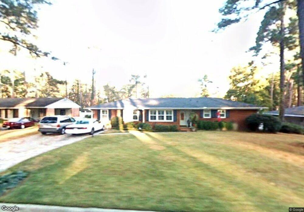
2915 Mayfair Rd Augusta, GA 30909
West Augusta NeighborhoodEstimated Value: $276,000 - $328,000
3
Beds
2
Baths
2,012
Sq Ft
$150/Sq Ft
Est. Value
About This Home
This home is located at 2915 Mayfair Rd, Augusta, GA 30909 and is currently estimated at $301,386, approximately $149 per square foot. 2915 Mayfair Rd is a home located in Richmond County with nearby schools including Tutt Middle School, Johnson Magnet, and Westside High School.
Ownership History
Date
Name
Owned For
Owner Type
Purchase Details
Closed on
May 8, 1991
Sold by
Lowe Vivian J
Bought by
Walden Fred Q Walden Kay R
Current Estimated Value
Purchase Details
Closed on
Apr 29, 1991
Sold by
Lowe Vivian J
Bought by
Walden Fred Q
Purchase Details
Closed on
Dec 1, 1983
Purchase Details
Closed on
Aug 1, 1977
Purchase Details
Closed on
Nov 1, 1974
Create a Home Valuation Report for This Property
The Home Valuation Report is an in-depth analysis detailing your home's value as well as a comparison with similar homes in the area
Home Values in the Area
Average Home Value in this Area
Purchase History
| Date | Buyer | Sale Price | Title Company |
|---|---|---|---|
| Walden Fred Q Walden Kay R | -- | -- | |
| Walden Fred Q | $79,900 | -- | |
| -- | $55,000 | -- | |
| -- | $41,200 | -- | |
| -- | $35,000 | -- |
Source: Public Records
Tax History
| Year | Tax Paid | Tax Assessment Tax Assessment Total Assessment is a certain percentage of the fair market value that is determined by local assessors to be the total taxable value of land and additions on the property. | Land | Improvement |
|---|---|---|---|---|
| 2025 | $1,345 | $112,636 | $15,600 | $97,036 |
| 2024 | $1,345 | $101,096 | $15,600 | $85,496 |
| 2023 | $1,211 | $87,112 | $15,600 | $71,512 |
| 2022 | $1,312 | $93,543 | $15,600 | $77,943 |
| 2021 | $1,242 | $77,833 | $15,600 | $62,233 |
| 2020 | $1,108 | $65,696 | $11,000 | $54,696 |
| 2019 | $1,158 | $65,696 | $11,000 | $54,696 |
| 2018 | $1,164 | $65,696 | $11,000 | $54,696 |
| 2017 | $2,320 | $65,696 | $11,000 | $54,696 |
| 2016 | $2,404 | $68,223 | $11,000 | $57,223 |
| 2015 | $2,421 | $68,223 | $11,000 | $57,223 |
| 2014 | $2,424 | $68,223 | $11,000 | $57,223 |
Source: Public Records
Map
Nearby Homes
- 2908 Stratford Dr
- 427 Aumond Rd
- 2902 Sussex Rd
- 434 Aumond Rd
- 441 Aumond Rd
- 505 Stratford Dr
- 2504 Pinebluff Ct
- 2507 Pinebluff Ct
- 2918 Arrowhead Dr
- 2904 Arrowhead Dr
- 2703 Oakbluff Ct
- 519 Ashland Dr
- 2706 Butler Place
- 481 Boy Scout Rd
- 3118 Exeter Rd
- 3120 Edinburgh Dr
- 513 Henderson Dr
- 3123 Exeter Rd
- 3121 Ramsgate Rd
- 603 Trafalgar Ln
- 2917 Mayfair Rd
- 2913 Mayfair Rd
- 2910 Stratford Dr
- 2928 Mayfair Rd
- 2912 Mayfair Rd
- 2912 Stratford Dr
- 2930 Mayfair Rd
- 2919 Mayfair Rd
- 2911 Mayfair Rd
- 2914 Mayfair Rd
- 2914 Stratford Dr
- 2924 Mayfair Rd
- 2924 Mayfair Ct
- 2906 Stratford Dr
- 2912 Mayfair Rd
- 2909 Mayfair Rd
- 2926 Mayfair Rd
- 2921 Mayfair Rd
- 2916 Stratford Dr
- 2927 Strafford Dr
Your Personal Tour Guide
Ask me questions while you tour the home.