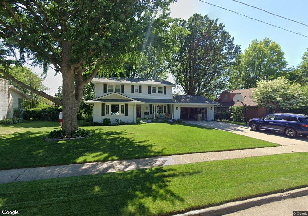
2916 Sherry Ln Urbandale, IA 50322
Estimated Value: $363,000 - $422,000
4
Beds
4
Baths
2,072
Sq Ft
$184/Sq Ft
Est. Value
About This Home
This home is located at 2916 Sherry Ln, Urbandale, IA 50322 and is currently estimated at $381,400, approximately $184 per square foot. 2916 Sherry Ln is a home located in Polk County with nearby schools including Crestview Elementary School, Indian Hills Junior High School, and Valley Southwoods Freshman High School.
Ownership History
Date
Name
Owned For
Owner Type
Purchase Details
Closed on
Apr 3, 2025
Sold by
Anderegg Martin R and Leigh Anne
Bought by
Martin Robert Anderegg Trust and Leigh Anne Anderegg Trust
Current Estimated Value
Purchase Details
Closed on
Feb 3, 2025
Sold by
Martin Robert Anderegg Trust and Leigh Anne Anderegg Trust
Bought by
Anderegg Martin Robert and Anderegg Leigh Anne
Purchase Details
Closed on
Dec 9, 2022
Sold by
Anderegg Martin R and Leigh Anne
Bought by
Martin Robert Anderegg Trust and Leigh Anne Anderegg Trust
Purchase Details
Closed on
Aug 11, 1997
Sold by
Mossman David and Singbush Mossman Lynn C
Bought by
Anderegg Martin R and Anderegg Leigh Anne
Home Financials for this Owner
Home Financials are based on the most recent Mortgage that was taken out on this home.
Original Mortgage
$118,400
Interest Rate
7.57%
Mortgage Type
Balloon
Create a Home Valuation Report for This Property
The Home Valuation Report is an in-depth analysis detailing your home's value as well as a comparison with similar homes in the area
Home Values in the Area
Average Home Value in this Area
Purchase History
| Date | Buyer | Sale Price | Title Company |
|---|---|---|---|
| Martin Robert Anderegg Trust | -- | None Listed On Document | |
| Anderegg Martin Robert | -- | None Listed On Document | |
| Anderegg Martin Robert | -- | None Listed On Document | |
| Martin Robert Anderegg Trust | -- | -- | |
| Anderegg Martin R | $147,500 | -- |
Source: Public Records
Mortgage History
| Date | Status | Borrower | Loan Amount |
|---|---|---|---|
| Previous Owner | Anderegg Martin R | $118,400 |
Source: Public Records
Tax History Compared to Growth
Tax History
| Year | Tax Paid | Tax Assessment Tax Assessment Total Assessment is a certain percentage of the fair market value that is determined by local assessors to be the total taxable value of land and additions on the property. | Land | Improvement |
|---|---|---|---|---|
| 2025 | $5,122 | $366,700 | $79,200 | $287,500 |
| 2024 | $5,122 | $341,700 | $72,900 | $268,800 |
| 2023 | $5,050 | $341,700 | $72,900 | $268,800 |
| 2022 | $4,988 | $277,300 | $61,100 | $216,200 |
| 2021 | $4,982 | $277,300 | $61,100 | $216,200 |
| 2020 | $4,904 | $262,500 | $57,700 | $204,800 |
| 2019 | $4,460 | $262,500 | $57,700 | $204,800 |
| 2018 | $4,298 | $228,800 | $48,700 | $180,100 |
| 2017 | $3,956 | $228,800 | $48,700 | $180,100 |
| 2016 | $3,854 | $206,400 | $43,300 | $163,100 |
| 2015 | $3,854 | $206,400 | $43,300 | $163,100 |
| 2014 | $3,654 | $201,300 | $41,800 | $159,500 |
Source: Public Records
Map
Nearby Homes
- 1630 Parkside Ln
- 1600 Parkside Ln
- 1590 Parkside Ln
- 1550 Parkside Ln
- Lot 1 Hillsdale Dr
- 3320 Patricia Dr
- 4517 90th St
- 4505 90th St
- 4500 90th St
- 37 89th St
- 3808 Mary Lynn Dr
- 3805 Melanie Cir
- 3889 92nd Dr
- 8826 Franklin Ave
- 3916 Greenview Dr
- 8115 Cobblestone Ct
- 3957 92nd Dr
- 3997 NW 179th Ct
- 8178 Dellwood Dr Unit 8178
- 1901 NW 89th St