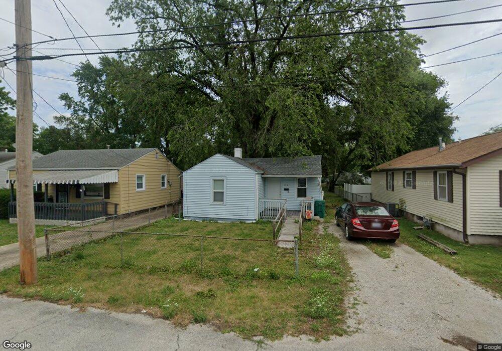
2918 S 12th St Springfield, IL 62703
Estimated Value: $48,000 - $84,000
1
Bed
1
Bath
660
Sq Ft
$95/Sq Ft
Est. Value
About This Home
This home is located at 2918 S 12th St, Springfield, IL 62703 and is currently estimated at $62,845, approximately $95 per square foot. 2918 S 12th St is a home located in Sangamon County with nearby schools including Edwin A. Lee Elementary School, Jefferson Middle School, and Springfield Southeast High School.
Ownership History
Date
Name
Owned For
Owner Type
Purchase Details
Closed on
Aug 9, 2012
Current Estimated Value
Purchase Details
Closed on
Oct 26, 2001
Purchase Details
Closed on
Oct 18, 2001
Purchase Details
Closed on
Jul 9, 2001
Purchase Details
Closed on
Oct 17, 2000
Purchase Details
Closed on
Oct 2, 1998
Purchase Details
Closed on
Oct 21, 1996
Purchase Details
Closed on
Oct 18, 1996
Create a Home Valuation Report for This Property
The Home Valuation Report is an in-depth analysis detailing your home's value as well as a comparison with similar homes in the area
Home Values in the Area
Average Home Value in this Area
Purchase History
| Date | Buyer | Sale Price | Title Company |
|---|---|---|---|
| -- | -- | -- | |
| -- | -- | -- | |
| -- | $14,000 | -- | |
| -- | -- | -- | |
| -- | -- | -- | |
| -- | -- | -- | |
| -- | $55,000 | -- | |
| -- | $22,000 | -- |
Source: Public Records
Tax History Compared to Growth
Tax History
| Year | Tax Paid | Tax Assessment Tax Assessment Total Assessment is a certain percentage of the fair market value that is determined by local assessors to be the total taxable value of land and additions on the property. | Land | Improvement |
|---|---|---|---|---|
| 2024 | $715 | $8,880 | $6,661 | $2,219 |
| 2023 | $702 | $8,223 | $6,168 | $2,055 |
| 2022 | $154 | $7,782 | $5,837 | $1,945 |
| 2021 | $147 | $7,477 | $5,608 | $1,869 |
| 2020 | $143 | $7,396 | $5,547 | $1,849 |
| 2019 | $606 | $7,267 | $5,450 | $1,817 |
| 2018 | $586 | $7,236 | $5,427 | $1,809 |
| 2017 | $135 | $7,125 | $5,344 | $1,781 |
| 2016 | $134 | $6,941 | $5,206 | $1,735 |
| 2015 | $382 | $6,784 | $5,088 | $1,696 |
| 2014 | $534 | $6,728 | $5,046 | $1,682 |
| 2013 | $526 | $6,800 | $5,100 | $1,700 |
Source: Public Records
Map
Nearby Homes
- 2910 S 14th St
- 2942 S 11th St
- 3106 S Woodward St Unit 1
- 2828 S Hoover Ave
- 1725 Adlai Stevenson Dr Unit 1
- 1004 Bryn Mawr Blvd
- 3209 Buckner St Unit 1
- 3301 Stanton St Unit 1
- 3201/3201 1/2 S 3rd St
- 2516 S 10th St
- 2517 S 10th St
- 3213 Sherman St Unit 1
- 2110 Bradley Ct
- Lot 1 & 2 Bunn Dr
- 2800 Via Rosso St Unit 135
- 2800 Via Rosso St Unit 50
- 2800 Via Rosso St Unit 194
- 3100 Butler St Unit 1833
- 2832 S 3rd St Unit 1
- 1937 E Pickett St Unit 1
- 2920 S 12th St Unit 1
- 2916 S 12th St Unit 1
- 2912 S 12th St Unit 1
- 2922 S 12th St Unit 1
- 2908 S 12th St
- 2911 S 12th St
- 2915 S 12th St Unit 1
- 2946 S 12th St Unit 1
- 2907 S 12th St Unit 1
- 2919 S 12th St
- 2906 S 12th St
- 2913 S 12th St
- 2909 S 12th St Unit 1
- 2923 S 12th St
- 2945 S 12th St Unit 1
- 2904 S 12th St Unit 1
- 2950 S 12th St Unit 1
- 2905 S 12th St Unit 1
- 2929 S 13th St
- 2927 S 13th St