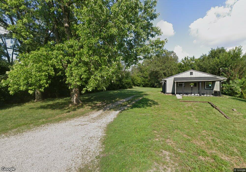
2919 Omaha St Middletown, OH 45044
Amanda-Oneida NeighborhoodEstimated Value: $172,000 - $436,000
2
Beds
1
Bath
960
Sq Ft
$271/Sq Ft
Est. Value
About This Home
This home is located at 2919 Omaha St, Middletown, OH 45044 and is currently estimated at $260,333, approximately $271 per square foot. 2919 Omaha St is a home located in Butler County with nearby schools including Amanda Elementary School, Highview 6th Grade Center, and Middletown Middle School.
Ownership History
Date
Name
Owned For
Owner Type
Purchase Details
Closed on
Sep 19, 2022
Sold by
Edwards Curtis and Edwards Shannon
Bought by
Th Property Owner I Llc
Current Estimated Value
Purchase Details
Closed on
Jan 15, 2021
Sold by
Lopez Jesus
Bought by
Edwards Curtis and Edwards Shannon
Purchase Details
Closed on
Feb 25, 2019
Sold by
Fiscus Jason and Fiscus Patricia
Bought by
Lopez Jesus
Purchase Details
Closed on
Oct 26, 2015
Sold by
Reynolds Roger
Bought by
Fiscus Jason
Purchase Details
Closed on
Sep 1, 1988
Create a Home Valuation Report for This Property
The Home Valuation Report is an in-depth analysis detailing your home's value as well as a comparison with similar homes in the area
Home Values in the Area
Average Home Value in this Area
Purchase History
| Date | Buyer | Sale Price | Title Company |
|---|---|---|---|
| Th Property Owner I Llc | $80,000 | -- | |
| Th Property Owner I Llc | $80,000 | None Listed On Document | |
| Edwards Curtis | $80,000 | Wave Title Agency Inc | |
| Lopez Jesus | -- | None Available | |
| Fiscus Jason | -- | Attorney | |
| -- | $33,500 | -- |
Source: Public Records
Tax History Compared to Growth
Tax History
| Year | Tax Paid | Tax Assessment Tax Assessment Total Assessment is a certain percentage of the fair market value that is determined by local assessors to be the total taxable value of land and additions on the property. | Land | Improvement |
|---|---|---|---|---|
| 2024 | $644 | $2,230 | $2,230 | -- |
| 2023 | $117 | $2,230 | $2,230 | -- |
| 2022 | $205 | $2,230 | $2,230 | $0 |
| 2021 | $128 | $2,230 | $2,230 | $0 |
| 2020 | $213 | $3,570 | $3,570 | $0 |
| 2019 | $318 | $3,240 | $3,240 | $0 |
| 2018 | $7,980 | $3,240 | $3,240 | $0 |
| 2017 | $210 | $3,240 | $3,240 | $0 |
| 2016 | $219 | $3,240 | $3,240 | $0 |
| 2015 | $216 | $3,240 | $3,240 | $0 |
| 2014 | $25,907 | $6,870 | $4,050 | $2,820 |
| 2013 | $25,907 | $19,040 | $4,050 | $14,990 |
Source: Public Records
Map
Nearby Homes
- 3102 Omaha St
- 3009 Seneca St
- 3111 Omaha St
- 1717 Pershing Ave
- 1702 Glenwood Ave
- 1613 Sheridan Ave
- 3221 Yankee Rd
- 2900 Morgan St
- 1709 Oxford State Rd
- 3107 Rufus St
- 3113 Rufus St
- 1808 Meadow Ave
- 1602 Oxford State Rd
- 3209 Rufus St
- 2012 Pearl St
- 1511 Meadow Ave
- 1713 Lafayette Ave
- 1514 Taylor Ave
- 3004 Judy Dr
- 3105 August Ave