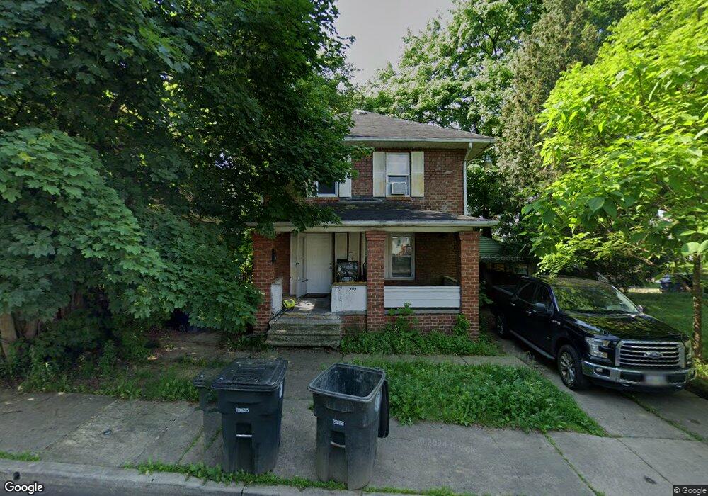
292 Gordon Dr Akron, OH 44302
Highland Square NeighborhoodEstimated Value: $84,000 - $109,000
3
Beds
1
Bath
1,168
Sq Ft
$80/Sq Ft
Est. Value
About This Home
This home is located at 292 Gordon Dr, Akron, OH 44302 and is currently estimated at $93,606, approximately $80 per square foot. 292 Gordon Dr is a home located in Summit County with nearby schools including Summit Academy School, Our Lady Of The Elms Elementary School, and Julie Billiart School Akron.
Ownership History
Date
Name
Owned For
Owner Type
Purchase Details
Closed on
Dec 9, 2025
Sold by
Vpjd Llc
Bought by
Jbh Saka Holdings Ohio Llc
Current Estimated Value
Home Financials for this Owner
Home Financials are based on the most recent Mortgage that was taken out on this home.
Original Mortgage
$2,100,000
Outstanding Balance
$2,100,000
Interest Rate
6.17%
Mortgage Type
Credit Line Revolving
Estimated Equity
-$2,006,394
Purchase Details
Closed on
Mar 5, 2018
Sold by
Nationwide Business Resorces Inc
Bought by
Vpjd Llc
Purchase Details
Closed on
Feb 21, 2018
Sold by
Klein Roger A
Bought by
Nationwide Business Presources Inc
Purchase Details
Closed on
Feb 10, 2015
Sold by
Klein Roger A
Bought by
Nbr Inc
Purchase Details
Closed on
Nov 3, 1999
Sold by
Lear Larry G and Lear Kimberly D
Bought by
Klein Roger A
Create a Home Valuation Report for This Property
The Home Valuation Report is an in-depth analysis detailing your home's value as well as a comparison with similar homes in the area
Home Values in the Area
Average Home Value in this Area
Purchase History
| Date | Buyer | Sale Price | Title Company |
|---|---|---|---|
| Jbh Saka Holdings Ohio Llc | $909,090 | None Listed On Document | |
| Vpjd Llc | -- | None Available | |
| Nationwide Business Presources Inc | -- | Buckeye Reserve Title Agency | |
| Nbr Inc | $16,000 | Buckeye Reserve Title Agency | |
| Klein Roger A | $20,000 | Midland Commerce Group |
Source: Public Records
Mortgage History
| Date | Status | Borrower | Loan Amount |
|---|---|---|---|
| Open | Jbh Saka Holdings Ohio Llc | $2,100,000 |
Source: Public Records
Tax History
| Year | Tax Paid | Tax Assessment Tax Assessment Total Assessment is a certain percentage of the fair market value that is determined by local assessors to be the total taxable value of land and additions on the property. | Land | Improvement |
|---|---|---|---|---|
| 2025 | $1,133 | $19,937 | $4,204 | $15,733 |
| 2024 | $1,133 | $19,937 | $4,204 | $15,733 |
| 2023 | $1,133 | $19,937 | $4,204 | $15,733 |
| 2022 | $869 | $11,725 | $2,471 | $9,254 |
| 2021 | $870 | $11,725 | $2,471 | $9,254 |
| 2020 | $858 | $11,720 | $2,470 | $9,250 |
| 2019 | $491 | $5,600 | $3,700 | $1,900 |
| 2018 | $486 | $5,600 | $3,700 | $1,900 |
| 2017 | $493 | $5,600 | $3,700 | $1,900 |
| 2016 | $493 | $5,600 | $3,700 | $1,900 |
| 2015 | $493 | $5,600 | $3,700 | $1,900 |
| 2014 | $838 | $10,430 | $3,700 | $6,730 |
| 2013 | $851 | $10,850 | $3,700 | $7,150 |
Source: Public Records
Map
Nearby Homes
- 985 Bloomfield Ave
- 286 Alhambra Way
- 1007 Delia Ave
- 931 Amelia Ave
- 1021 Delia Ave
- 978 Delia Ave
- 138 Marvin Ave
- 960 Whittier Ave
- 166 Marvin Ave
- 939 W Exchange St
- 892 Delia Ave
- 261 Madison Ave
- 952 Jefferson Ave
- 100 Corson Ave
- 101 Marvin Ave
- 962 Stadelman Ave
- 141 Storer Ave
- 908 Stadelman Ave
- 842 Stadelman Ave
- 1153 Sunset View Dr
- 288 Gordon Dr
- 965 Bloomfield Ave
- 153 Burton Ave
- 961 Bloomfield Ave
- 284 Gordon Dr
- 157 Burton Ave
- 143 Burton Ave
- 955 Bloomfield Ave
- 287 Gordon Dr
- 161 Burton Ave
- 280 Gordon Dr
- 283 Gordon Dr
- 951 Bloomfield Ave
- 276 Gordon Dr
- 135 Burton Ave
- 947 Bloomfield Ave
- 165 Burton Ave
- 275 Gordon Dr
- 960 Bloomfield Ave
- 272 Gordon Dr
Your Personal Tour Guide
Ask me questions while you tour the home.