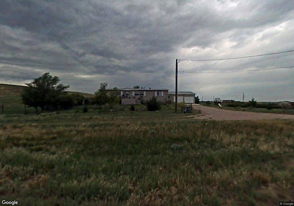
2920 Whitetail Rd Cheyenne, WY 82009
Ranchettes NeighborhoodEstimated Value: $514,000 - $618,000
--
Bed
--
Bath
1,726
Sq Ft
$325/Sq Ft
Est. Value
About This Home
This home is located at 2920 Whitetail Rd, Cheyenne, WY 82009 and is currently estimated at $560,923, approximately $324 per square foot. 2920 Whitetail Rd is a home located in Laramie County with nearby schools including Anderson Elementary School, Carey Junior High School, and East High School.
Ownership History
Date
Name
Owned For
Owner Type
Purchase Details
Closed on
Sep 1, 2011
Sold by
Peterson Lori Layne and Peterson Kara Layne
Bought by
Cole Lori Layne and Peterson Richard William
Current Estimated Value
Purchase Details
Closed on
Feb 24, 2004
Sold by
Cole William L and Cole Joan M
Bought by
Peterson Lori Layne and Peterson Kara Layne
Purchase Details
Closed on
Sep 14, 1999
Sold by
Cole William L and Cole Joan M
Bought by
Cole William L and Cole Joan M
Create a Home Valuation Report for This Property
The Home Valuation Report is an in-depth analysis detailing your home's value as well as a comparison with similar homes in the area
Home Values in the Area
Average Home Value in this Area
Purchase History
| Date | Buyer | Sale Price | Title Company |
|---|---|---|---|
| Cole Lori Layne | -- | None Available | |
| Peterson Lori Layne | -- | -- | |
| Cole William L | -- | -- |
Source: Public Records
Tax History Compared to Growth
Tax History
| Year | Tax Paid | Tax Assessment Tax Assessment Total Assessment is a certain percentage of the fair market value that is determined by local assessors to be the total taxable value of land and additions on the property. | Land | Improvement |
|---|---|---|---|---|
| 2025 | $2,604 | $29,940 | $7,090 | $22,850 |
| 2024 | $2,604 | $38,748 | $9,454 | $29,294 |
| 2023 | $2,472 | $37,622 | $9,454 | $28,168 |
| 2022 | $2,127 | $31,664 | $8,199 | $23,465 |
| 2021 | $1,991 | $29,563 | $8,588 | $20,975 |
| 2020 | $1,859 | $27,693 | $9,594 | $18,099 |
| 2019 | $1,749 | $26,027 | $9,018 | $17,009 |
| 2018 | $1,572 | $23,636 | $8,403 | $15,233 |
| 2017 | $1,377 | $20,506 | $5,765 | $14,741 |
| 2016 | $1,347 | $20,048 | $5,674 | $14,374 |
| 2015 | $1,297 | $19,285 | $5,674 | $13,611 |
| 2014 | $1,313 | $19,390 | $5,674 | $13,716 |
Source: Public Records
Map
Nearby Homes
- 8012 Bobcat Rd
- 6712 Big Sky Trail
- 5124 Sullivan St
- 2553 Wildhorse Trail
- TBD Welchester Dr
- 4814 Oasis St
- 3117 Holland Ct
- 3603 Storey Blvd
- 1348 Jack Ln
- 2544 Levi Rd
- 3014 Smith Place
- 8007 Kepler Dr
- 1348 Jessi Dr
- 5801 Mica Bluff
- 2601 Foothills Rd
- 1336 Jessi Dr
- TBD Kepler Dr
- 5702 Mica Bluff
- 3310 Thomas Rd
- 3707 Harvey St
- 8210 Bobcat Rd
- 8210 Jack Rabbit Rd
- 8009 Bobcat Rd
- 7908 Bobcat Rd
- 8314 Bobcat Rd
- 8114 Jack Rabbit Rd
- 3054 Lynx Rd
- 2827 Whitetail Rd
- 7912 Jack Rabbit Rd
- 8109 Red Fox Rd
- 8211 Red Fox Rd
- 8406 Bobcat Rd
- 8011 Jack Rabbit Rd
- 8313 Red Fox Rd
- 7720 Jack Rabbit Rd
- 7905 Red Fox Rd
- 8115 Jack Rabbit Rd
- 8405 Red Fox Rd
- 7913 Jack Rabbit Rd
- 8213 Jack Rabbit Rd