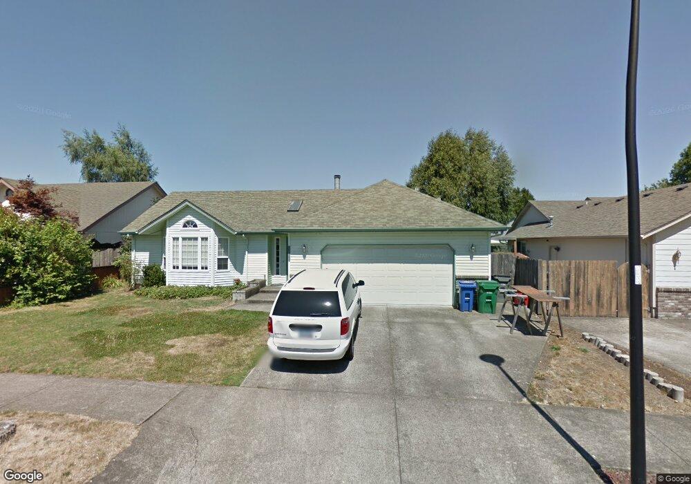
2929 Brett Loop Eugene, OR 97404
Santa Clara NeighborhoodEstimated Value: $444,467 - $519,000
3
Beds
2
Baths
1,605
Sq Ft
$297/Sq Ft
Est. Value
About This Home
This home is located at 2929 Brett Loop, Eugene, OR 97404 and is currently estimated at $476,617, approximately $296 per square foot. 2929 Brett Loop is a home located in Lane County with nearby schools including Spring Creek Elementary School, Madison Middle School, and North Eugene High School.
Ownership History
Date
Name
Owned For
Owner Type
Purchase Details
Closed on
Dec 31, 2004
Sold by
Tomlinson Warehouse Nevada Inc
Bought by
Twn Properties Llc
Current Estimated Value
Purchase Details
Closed on
Jun 28, 2004
Sold by
Salahor Richard J
Bought by
Tomlinson Warehouse Nevada Inc
Purchase Details
Closed on
Aug 9, 2000
Sold by
Michael Loewenstein David
Bought by
Salahor Richard J
Home Financials for this Owner
Home Financials are based on the most recent Mortgage that was taken out on this home.
Original Mortgage
$143,910
Interest Rate
10.95%
Create a Home Valuation Report for This Property
The Home Valuation Report is an in-depth analysis detailing your home's value as well as a comparison with similar homes in the area
Home Values in the Area
Average Home Value in this Area
Purchase History
| Date | Buyer | Sale Price | Title Company |
|---|---|---|---|
| Twn Properties Llc | -- | -- | |
| Tomlinson Warehouse Nevada Inc | $187,000 | Evergreen Land Title Co | |
| Salahor Richard J | $159,900 | Western Pioneer Title Co |
Source: Public Records
Mortgage History
| Date | Status | Borrower | Loan Amount |
|---|---|---|---|
| Previous Owner | Salahor Richard J | $143,910 | |
| Closed | Salahor Richard J | $15,990 |
Source: Public Records
Tax History
| Year | Tax Paid | Tax Assessment Tax Assessment Total Assessment is a certain percentage of the fair market value that is determined by local assessors to be the total taxable value of land and additions on the property. | Land | Improvement |
|---|---|---|---|---|
| 2025 | $4,803 | $246,496 | -- | -- |
| 2024 | $4,743 | $239,317 | -- | -- |
| 2023 | $4,743 | $232,347 | $0 | $0 |
| 2022 | $4,443 | $225,580 | $0 | $0 |
| 2021 | $4,173 | $219,010 | $0 | $0 |
| 2020 | $4,188 | $212,632 | $0 | $0 |
| 2019 | $4,045 | $206,439 | $0 | $0 |
| 2018 | $3,807 | $194,589 | $0 | $0 |
| 2017 | $3,628 | $194,589 | $0 | $0 |
| 2016 | $3,442 | $188,921 | $0 | $0 |
| 2015 | $3,292 | $183,418 | $0 | $0 |
| 2014 | $3,205 | $178,076 | $0 | $0 |
Source: Public Records
Map
Nearby Homes
- 2721 La Darrah St
- 349 Irving Rd
- 3256 Marvin Dr
- 2563 York St
- 805 Impala Ave
- 541 Durham Ave
- 374 Blackfoot Ave
- 200 Irving Rd
- 215 Jonquil Ave
- 303 Lenore Loop
- 2987 Dry Creek Rd
- 193 Santa Clara Ave
- 2965 Teal Place
- 2488 Northampton
- 190 River Loop 1
- 2418 Kalmia St
- 2439 Quince St
- 2931 Shelby Way
- 1256 Frogs Leap Ln
- 401 Sterling Dr
- 2925 Brett Loop
- 2933 Brett Loop
- 2979 Brett Loop
- 2975 Brett Loop
- 2937 Brett Loop
- 2928 Brett Loop
- 2983 Brett Loop
- 2932 Brett Loop
- 2969 Brett Loop
- 2924 Brett Loop
- 2938 Brett Loop
- 2920 Brett Loop
- 2950 Shirley St
- 2978 Shirley St
- 2994 Shirley St
- 2878 Shirley St
- 2987 Brett Loop
- 2918 Shirley St
- 2942 Brett Loop
- 2995 Brett Loop
Your Personal Tour Guide
Ask me questions while you tour the home.