Estimated Value: $289,000 - $462,000
3
Beds
2
Baths
2,172
Sq Ft
$163/Sq Ft
Est. Value
About This Home
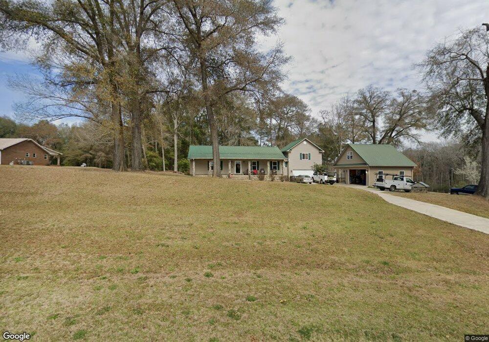
This home is located at 293 Todd Rd, Perry, GA 31069 and is currently estimated at $353,856, approximately $162 per square foot. 293 Todd Rd is a home located in Houston County with nearby schools including Langston Road Elementary School, Mossy Creek Middle School, and Perry High School.
Ownership History
Date
Name
Owned For
Owner Type
Purchase Details
Closed on
Mar 23, 2004
Sold by
Engle Allen Dale
Bought by
Engle Allen Dale and Engle Jeanne R
Current Estimated Value
Purchase Details
Closed on
Mar 10, 2004
Sold by
Engle Marsha Ann
Bought by
Engle Allen Dale
Purchase Details
Closed on
Jul 30, 2002
Sold by
Engle Marsha Ann
Bought by
Engle Allen Dale
Purchase Details
Closed on
Jul 16, 1998
Sold by
Engle Allen Dale
Bought by
Engle Marsha Ann
Purchase Details
Closed on
May 30, 1996
Bought by
Engle Allen Dale and Marsha Ann
Create a Home Valuation Report for This Property
The Home Valuation Report is an in-depth analysis detailing your home's value as well as a comparison with similar homes in the area
Home Values in the Area
Average Home Value in this Area
Purchase History
| Date | Buyer | Sale Price | Title Company |
|---|---|---|---|
| Engle Allen Dale | -- | -- | |
| Engle Allen Dale | -- | -- | |
| Engle Allen Dale | -- | -- | |
| Engle Marsha Ann | -- | -- | |
| Engle Allen Dale | -- | -- |
Source: Public Records
Tax History
| Year | Tax Paid | Tax Assessment Tax Assessment Total Assessment is a certain percentage of the fair market value that is determined by local assessors to be the total taxable value of land and additions on the property. | Land | Improvement |
|---|---|---|---|---|
| 2024 | $1,909 | $81,800 | $9,400 | $72,400 |
| 2023 | $1,632 | $69,520 | $6,400 | $63,120 |
| 2022 | $1,442 | $61,640 | $6,400 | $55,240 |
| 2021 | $1,275 | $54,480 | $4,640 | $49,840 |
| 2020 | $1,249 | $51,040 | $4,480 | $46,560 |
| 2019 | $1,197 | $51,040 | $4,480 | $46,560 |
| 2018 | $1,197 | $51,040 | $4,480 | $46,560 |
| 2017 | $1,198 | $51,040 | $4,480 | $46,560 |
| 2016 | $1,200 | $51,040 | $4,480 | $46,560 |
| 2015 | $1,202 | $51,040 | $4,480 | $46,560 |
| 2014 | -- | $51,040 | $4,480 | $46,560 |
| 2013 | -- | $51,040 | $4,480 | $46,560 |
Source: Public Records
Map
Nearby Homes
- 0 Todd Rd Unit 253674
- 309 Bermuda Ridge
- 108 Chimney Rock Rd
- 102 Steerwood Trail
- 204 Greylock Dr
- 103 Denali Dr
- 2327 Us Hwy 41
- 124 Lake Lillian Dr
- 12754 State Route 96
- 502 Arons Ct
- 107 Waldorf Dr
- 624 Wantland Rd
- 115 Woody Dr
- 150 MacK Thompson Rd
- 0 MacK Thompson Rd Unit 253661
- 149 MacK Thompson Road Common
- 200 River Oak Ct
- 2636 Us Highway 41
- 0 Hwy 41 & Langston Rd Unit M170042
- Savannah Plan at Bankstone Landing
- 293 Todd Rd Unit A
- 7363 Buckeye Rd
- 7409 Buckeye Rd
- 0 Buckeye Rd Unit PAR C 3185634
- 0 Buckeye Rd Unit L2A,AC9000 7439580
- 0 Buckeye Rd Unit L2b 8048500
- 0 Buckeye Rd Unit 8065245
- 0 Buckeye Rd Unit 214166
- 0 Buckeye Rd Unit Tract A 8079804
- 0 Buckeye Rd Unit M136761
- 0 Buckeye Rd Unit M137165
- 0 Buckeye Rd Unit 8743545
- 0 Buckeye Rd Unit 201195
- 0 Buckeye Rd Unit 122838
- 0 Buckeye Rd Unit Parcel D 185411
- 287 Todd Rd
- 7287 Buckeye Rd
- 7314 Buckeye Rd
- 6637 Buckeye Rd
- 7221 Buckeye Rd
Your Personal Tour Guide
Ask me questions while you tour the home.