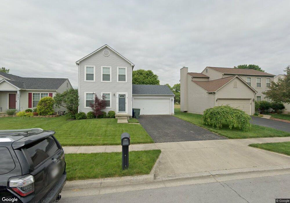
2937 Tracer Rd Columbus, OH 43232
Glenbrook NeighborhoodEstimated Value: $252,815 - $285,000
3
Beds
3
Baths
1,224
Sq Ft
$217/Sq Ft
Est. Value
About This Home
This home is located at 2937 Tracer Rd, Columbus, OH 43232 and is currently estimated at $265,454, approximately $216 per square foot. 2937 Tracer Rd is a home located in Franklin County with nearby schools including Groveport Madison High School, Millennium Community School, and Eastland Preparatory Academy.
Ownership History
Date
Name
Owned For
Owner Type
Purchase Details
Closed on
Apr 12, 2018
Sold by
Us Bank Na
Bought by
Moore Robert and Moore Sarah
Current Estimated Value
Home Financials for this Owner
Home Financials are based on the most recent Mortgage that was taken out on this home.
Original Mortgage
$64,600
Interest Rate
4.42%
Create a Home Valuation Report for This Property
The Home Valuation Report is an in-depth analysis detailing your home's value as well as a comparison with similar homes in the area
Home Values in the Area
Average Home Value in this Area
Purchase History
| Date | Buyer | Sale Price | Title Company |
|---|---|---|---|
| Moore Robert | -- | -- |
Source: Public Records
Mortgage History
| Date | Status | Borrower | Loan Amount |
|---|---|---|---|
| Previous Owner | Moore Robert | $64,600 | |
| Previous Owner | Moore Robert | -- |
Source: Public Records
Tax History Compared to Growth
Tax History
| Year | Tax Paid | Tax Assessment Tax Assessment Total Assessment is a certain percentage of the fair market value that is determined by local assessors to be the total taxable value of land and additions on the property. | Land | Improvement |
|---|---|---|---|---|
| 2024 | $3,120 | $73,570 | $21,000 | $52,570 |
| 2023 | $3,090 | $73,570 | $21,000 | $52,570 |
| 2022 | $2,018 | $39,970 | $6,230 | $33,740 |
| 2021 | $2,024 | $39,970 | $6,230 | $33,740 |
| 2020 | $2,028 | $39,970 | $6,230 | $33,740 |
| 2019 | $1,834 | $32,340 | $4,970 | $27,370 |
| 2018 | $1,969 | $32,340 | $4,970 | $27,370 |
| 2017 | $1,851 | $32,340 | $4,970 | $27,370 |
| 2016 | $2,070 | $33,040 | $7,420 | $25,620 |
| 2015 | $2,092 | $33,040 | $7,420 | $25,620 |
| 2014 | $2,116 | $33,040 | $7,420 | $25,620 |
| 2013 | $932 | $34,755 | $7,805 | $26,950 |
Source: Public Records
Map
Nearby Homes
- 3021 Tracer Rd
- 3059 Remington Ridge Rd
- 3111 Briar Ridge Rd
- 2964 Askins Rd
- 2835 Schwartz Rd
- 3130 Marwick Rd
- 2825 S Hampton Rd
- 3114 Wessex Ct
- 3471 Marlin Dr
- 2979 Lake Park Dr
- 3075 Wessex Ct
- 0 Wessex Ct
- 2410 Clarkston Ln
- 3806 Charbonnett Ct
- 3488 Oakcrest Rd
- 2275 Cardston Ct
- 2503 Burgandy Ln Unit 46A
- 2275 Wadsworth Dr
- 3330 Balford Square S
- 4479 Gerling Blvd
- 2943 Tracer Rd
- 2931 Tracer Rd
- 2925 Tracer Rd
- 2955 Tracer Rd
- 2938 Tracer Rd
- 2932 Tracer Rd
- 2950 Tracer Rd
- 2926 Tracer Rd
- 2961 Tracer Rd
- 2956 Tracer Rd
- 2967 Tracer Rd
- 2962 Tracer Rd
- 3540 Wesson Dr
- 3534 Wesson Dr
- 2963 Stonebluff Dr
- 3546 Wesson Dr
- 2957 Stonebluff Dr
- 2969 Stonebluff Dr
- 2975 Stonebluff Dr
- 3552 Wesson Dr