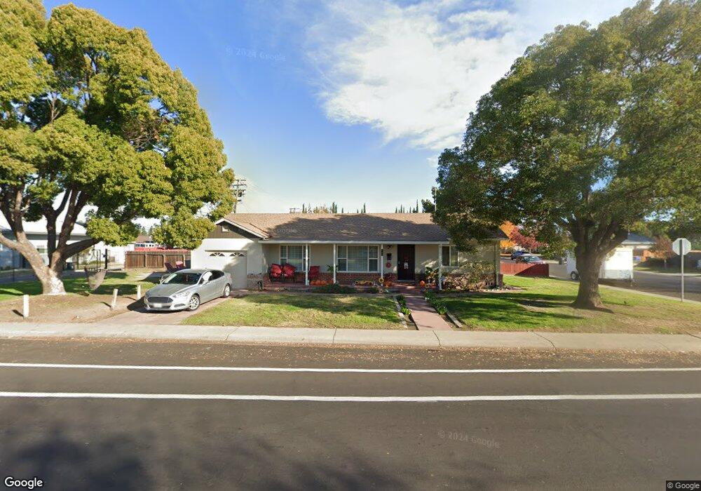
294 S Powers Ave Manteca, CA 95336
Downtown Manteca NeighborhoodEstimated Value: $393,745 - $427,000
About This Home
This home is located at 294 S Powers Ave, Manteca, CA 95336 and is currently estimated at $410,436, approximately $367 per square foot. 294 S Powers Ave is a home located in San Joaquin County with nearby schools including Lincoln Elementary School, Manteca High School, and St. Anthony's Catholic School.
Ownership History
We collect this data history from publicly available records. To have your information removed, we recommend requesting removal directly through your county’s website.
Purchase Details
Purchase Details
Purchase Details
Home Values in the Area
Average Home Value in this Area
Purchase History
We collect this data history from publicly available records. To have your information removed, we recommend requesting removal directly through your county’s website.
| Date | Buyer | Sale Price | Title Company |
|---|---|---|---|
| -- | None Available | ||
| -- | None Available | ||
| -- | -- |
Tax History
We collect this data history from publicly available records. To have your information removed, we recommend requesting removal directly through your county’s website.
| Year | Tax Paid | Tax Assessment Tax Assessment Total Assessment is a certain percentage of the fair market value that is determined by local assessors to be the total taxable value of land and additions on the property. | Land | Improvement |
|---|---|---|---|---|
| 2025 | $1,236 | $109,708 | $25,811 | $83,897 |
| 2024 | $1,201 | $107,557 | $25,305 | $82,252 |
| 2023 | $1,187 | $105,449 | $24,809 | $80,640 |
| 2022 | $1,169 | $103,382 | $24,323 | $79,059 |
| 2021 | $1,156 | $101,356 | $23,847 | $77,509 |
| 2020 | $1,110 | $100,318 | $23,603 | $76,715 |
| 2019 | $1,096 | $98,352 | $23,141 | $75,211 |
| 2018 | $1,081 | $96,425 | $22,688 | $73,737 |
| 2017 | $1,066 | $94,536 | $22,244 | $72,292 |
| 2016 | $1,040 | $92,683 | $21,808 | $70,875 |
| 2015 | $1,034 | $91,291 | $21,480 | $69,811 |
| 2014 | $969 | $89,504 | $21,060 | $68,444 |
Map
- 317 Moffat Blvd Unit 21
- 317 Moffat Blvd Unit 14
- 317 Moffat Blvd Unit 6
- 317 Moffat Blvd Unit 5
- 1009 Lambdin St
- 1003 Trinity St
- 555 Moffat Blvd Unit 61
- 555 Moffat Blvd Unit 33
- 196 Dyer Ave
- 466 Moffat Blvd
- 651 Pine St
- 209 Charles Ave
- 119 N Sherman Ave
- 1177 Pine St
- 311 Charles Ave
- 605 S Main St
- 322 Mylnar Ave
- 139 Lupton St
- 719 S Maple Ave
- 241 Martha St
Ask me questions while you tour the home.