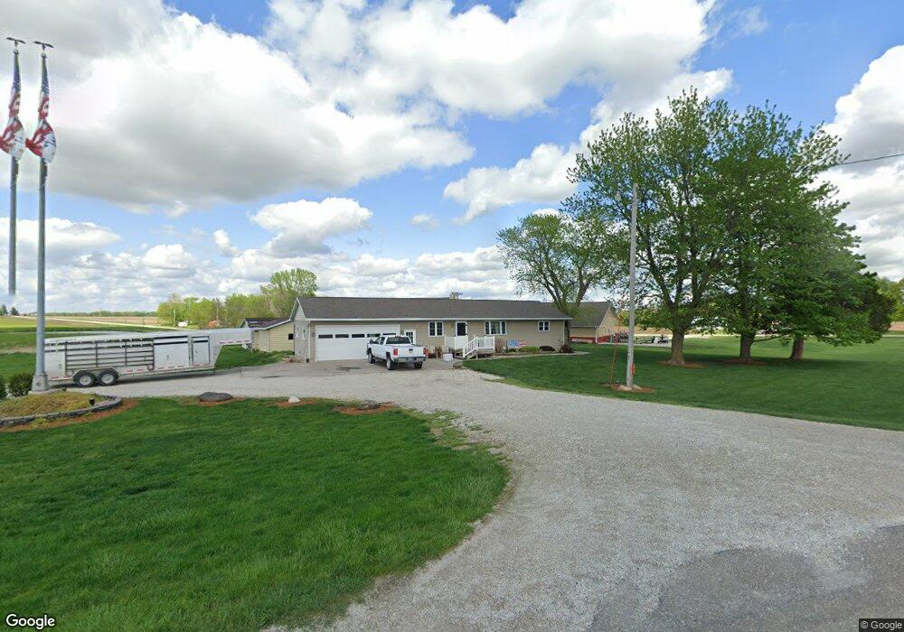
2949 Highway 16 West Point, IA 52656
Estimated Value: $187,000 - $235,000
4
Beds
3
Baths
2,044
Sq Ft
$103/Sq Ft
Est. Value
About This Home
This home is located at 2949 Highway 16, West Point, IA 52656 and is currently estimated at $210,000, approximately $102 per square foot. 2949 Highway 16 is a home located in Lee County with nearby schools including Fort Madison High School.
Ownership History
Date
Name
Owned For
Owner Type
Purchase Details
Closed on
Nov 2, 2017
Sold by
Blanchard Lindy A
Bought by
Blanchard Scott B
Current Estimated Value
Purchase Details
Closed on
Feb 24, 2006
Sold by
Blanchard Nancy M
Bought by
Blanchard Scott B and Kenel Lindy
Home Financials for this Owner
Home Financials are based on the most recent Mortgage that was taken out on this home.
Original Mortgage
$100,000
Outstanding Balance
$56,296
Interest Rate
6.2%
Mortgage Type
Future Advance Clause Open End Mortgage
Estimated Equity
$153,704
Create a Home Valuation Report for This Property
The Home Valuation Report is an in-depth analysis detailing your home's value as well as a comparison with similar homes in the area
Home Values in the Area
Average Home Value in this Area
Purchase History
| Date | Buyer | Sale Price | Title Company |
|---|---|---|---|
| Blanchard Scott B | -- | None Available | |
| Blanchard Scott B | $96,750 | None Available |
Source: Public Records
Mortgage History
| Date | Status | Borrower | Loan Amount |
|---|---|---|---|
| Open | Blanchard Scott B | $100,000 |
Source: Public Records
Tax History Compared to Growth
Tax History
| Year | Tax Paid | Tax Assessment Tax Assessment Total Assessment is a certain percentage of the fair market value that is determined by local assessors to be the total taxable value of land and additions on the property. | Land | Improvement |
|---|---|---|---|---|
| 2025 | $2,820 | $241,320 | $24,070 | $217,250 |
| 2024 | $2,820 | $225,980 | $24,070 | $201,910 |
| 2023 | $2,754 | $225,980 | $24,070 | $201,910 |
| 2022 | $2,340 | $182,380 | $24,070 | $158,310 |
| 2021 | $2,340 | $182,380 | $24,070 | $158,310 |
| 2020 | $2,370 | $172,120 | $25,510 | $146,610 |
| 2019 | $2,294 | $172,120 | $25,510 | $146,610 |
| 2018 | $2,382 | $162,380 | $0 | $0 |
| 2017 | $2,382 | $162,380 | $0 | $0 |
| 2016 | $2,286 | $162,380 | $0 | $0 |
| 2015 | $2,286 | $160,190 | $0 | $0 |
| 2014 | $2,198 | $160,190 | $0 | $0 |
Source: Public Records
Map
Nearby Homes
- 809 Houston Ave
- 5164 Augusta Main Rd
- 1684 345th Ave
- 910 Avenue D
- 10161 Jimtown Rd
- 1910 S Highway 61
- 74 A Green Bay Rd
- 3026 County Road 103
- 406 Center St
- 203 & 205-207 Center St
- 210 Louisiana St
- 208 Louisiana St
- 200 Louisiana St
- 2280 Windmill Way
- 2150 Business 61
- 103 Cherokee Ln
- 2331 Avenue A
- 5 Ridgewood Rd
- 8 Sharman Place
- RR Woodland Heights Ct
- 1461 295th Ave
- 1463 295th Ave
- 1460 295th Ave
- 1446 295th Ave
- 0 295 Th Ave Unit 25118611
- 0 295 Th Ave Unit 5426179
- 1442 295th Ave
- 809 Turner Ave
- 806 Turner Ave
- 803 Turner Ave
- 89 Denmark 7th St
- 707 Turner Ave
- 1006 Academy Ave
- 79 Denmark 7th St
- 1002 Academy Ave
- 1483 295th Ave
- 1493 295th Ave
- 708 Turner Ave
- 2917 Highway 16
- 1492 295 Th