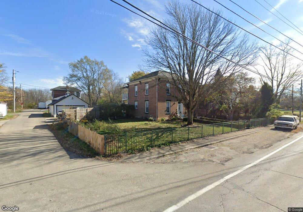
295 Pc Geo Rd SE Galloway, OH 43119
Estimated Value: $341,000 - $430,000
2
Beds
1
Bath
1,690
Sq Ft
$226/Sq Ft
Est. Value
About This Home
This home is located at 295 Pc Geo Rd SE, Galloway, OH 43119 and is currently estimated at $382,637, approximately $226 per square foot. 295 Pc Geo Rd SE is a home located in Madison County with nearby schools including Norwood Elementary School, West Jefferson Middle School, and West Jefferson High School.
Ownership History
Date
Name
Owned For
Owner Type
Purchase Details
Closed on
Dec 14, 2015
Sold by
Morgan Larry and Morgan Kathy
Bought by
Blevins Glenwood and Blevins Ellen Christine
Current Estimated Value
Home Financials for this Owner
Home Financials are based on the most recent Mortgage that was taken out on this home.
Original Mortgage
$136,000
Outstanding Balance
$56,983
Interest Rate
3.96%
Mortgage Type
New Conventional
Estimated Equity
$325,654
Create a Home Valuation Report for This Property
The Home Valuation Report is an in-depth analysis detailing your home's value as well as a comparison with similar homes in the area
Home Values in the Area
Average Home Value in this Area
Purchase History
| Date | Buyer | Sale Price | Title Company |
|---|---|---|---|
| Blevins Glenwood | $170,000 | Attorney |
Source: Public Records
Mortgage History
| Date | Status | Borrower | Loan Amount |
|---|---|---|---|
| Open | Blevins Glenwood | $136,000 |
Source: Public Records
Tax History Compared to Growth
Tax History
| Year | Tax Paid | Tax Assessment Tax Assessment Total Assessment is a certain percentage of the fair market value that is determined by local assessors to be the total taxable value of land and additions on the property. | Land | Improvement |
|---|---|---|---|---|
| 2024 | $3,913 | $97,310 | $18,030 | $79,280 |
| 2023 | $3,913 | $97,310 | $18,030 | $79,280 |
| 2022 | $3,074 | $72,780 | $13,280 | $59,500 |
| 2021 | $2,728 | $65,310 | $13,280 | $52,030 |
| 2020 | $2,776 | $65,310 | $13,280 | $52,030 |
| 2019 | $2,475 | $58,560 | $15,530 | $43,030 |
| 2018 | $2,302 | $58,560 | $15,530 | $43,030 |
| 2017 | $1,718 | $58,560 | $15,530 | $43,030 |
| 2016 | $1,732 | $45,350 | $15,530 | $29,820 |
| 2015 | $2,220 | $45,350 | $15,530 | $29,820 |
| 2014 | $2,220 | $45,350 | $15,530 | $29,820 |
| 2013 | -- | $47,110 | $12,940 | $34,170 |
Source: Public Records
Map
Nearby Homes
- 270 State Route 142 NE
- 545 Trillium Dr
- 360 State Route 142 NE
- 74 S Chester St
- 63 Jones St
- 312 Larkspur Dr
- 430 Trillium Dr
- 435 Trillium Dr
- 70 Riverside Dr
- 10763 Southwood Rd
- 200 Smith St
- 248 London Rd
- 283 Madison Dr N
- 22 N Franklin St
- 304 Middle Dr
- 287 Greenlake St
- 8595 Abbot Cove Ave
- 8626 Fairbrook Ave
- 106 Kings Way Unit 4
- 8482 Dover Crest Ct
- 275 Pc Geo Rd SE
- 275 Plain City Georgesville Rd SE
- 275 Plain City-Georgesville Rd SE
- 325 Plain City Georgesville Rd SE
- 280 Pc Geo Rd SE
- 225 Pc Geo Rd SE
- 335 Pc Geo Rd SE
- 260 Pc Geo Rd SE
- 215 Pc Geo Rd SE
- 251 Plain City Georgesville Rd SE
- 251 Plain City Georgesville Rd SE
- 230 Pc Geo Rd SE
- 340 Pc Geo Rd SE
- 345 Pc Geo Rd SE
- 171 Plain City Georgesville Rd SE
- 171 Plain City-Georgesville Rd SE
- 0 Plain City Georgesville Rd Unit 211019533
- 171 Plain City Geo Rd
- 310 Pc Geo Rd SE
- 310 Plain City Georgesville Rd SE