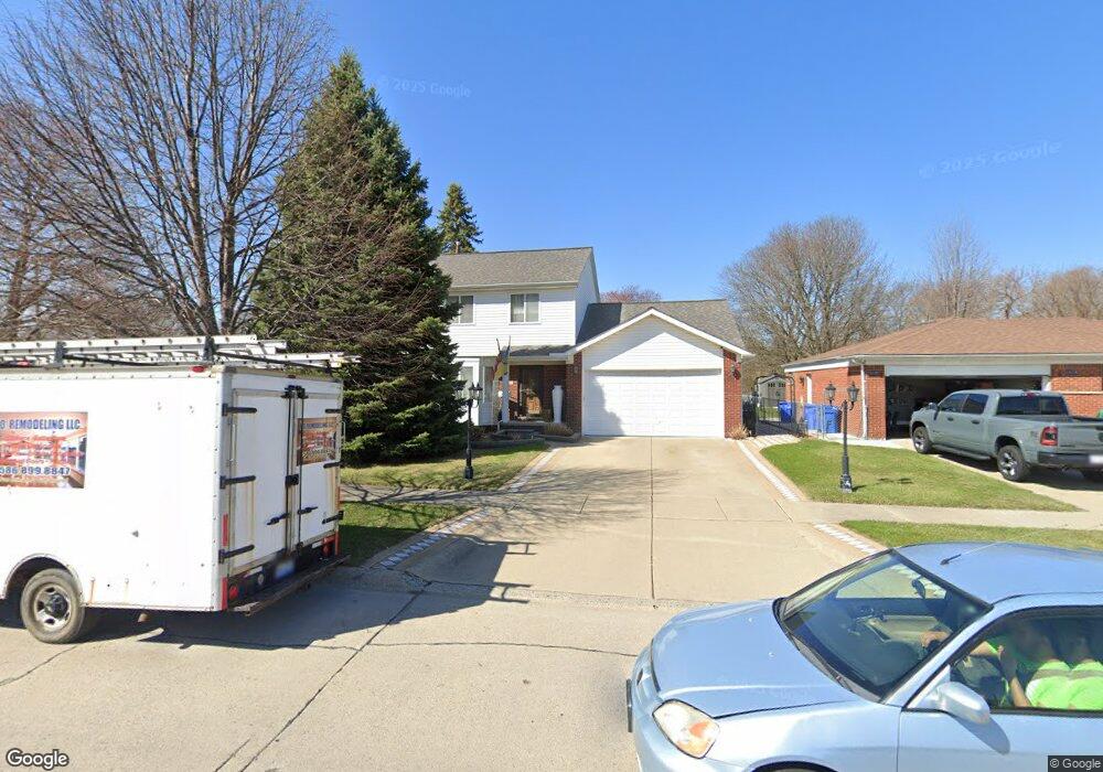
29531 Westbrook Ave Warren, MI 48092
Northwest Warren NeighborhoodEstimated Value: $305,273 - $334,000
3
Beds
2
Baths
1,659
Sq Ft
$191/Sq Ft
Est. Value
About This Home
This home is located at 29531 Westbrook Ave, Warren, MI 48092 and is currently estimated at $316,318, approximately $190 per square foot. 29531 Westbrook Ave is a home located in Macomb County with nearby schools including Lean Elementary School, Beer Middle School, and Warren Mott High School.
Ownership History
Date
Name
Owned For
Owner Type
Purchase Details
Closed on
Apr 10, 2000
Sold by
Ryan Rick W
Bought by
Holodnyuk Orest
Current Estimated Value
Purchase Details
Closed on
Sep 8, 1995
Sold by
Briarwood Bldrs Inc
Bought by
Ryan R and Ryan J
Purchase Details
Closed on
Apr 25, 1995
Sold by
Rose Elizabeth A
Bought by
Briarwood Bldrs Inc
Create a Home Valuation Report for This Property
The Home Valuation Report is an in-depth analysis detailing your home's value as well as a comparison with similar homes in the area
Home Values in the Area
Average Home Value in this Area
Purchase History
| Date | Buyer | Sale Price | Title Company |
|---|---|---|---|
| Holodnyuk Orest | $171,000 | -- | |
| Ryan R | $135,600 | -- | |
| Briarwood Bldrs Inc | $24,000 | -- |
Source: Public Records
Mortgage History
| Date | Status | Borrower | Loan Amount |
|---|---|---|---|
| Closed | Briarwood Bldrs Inc | $0 |
Source: Public Records
Tax History
| Year | Tax Paid | Tax Assessment Tax Assessment Total Assessment is a certain percentage of the fair market value that is determined by local assessors to be the total taxable value of land and additions on the property. | Land | Improvement |
|---|---|---|---|---|
| 2025 | $4,170 | $141,460 | $0 | $0 |
| 2024 | $41 | $128,040 | $0 | $0 |
| 2023 | $3,868 | $124,980 | $0 | $0 |
| 2022 | $3,737 | $111,460 | $0 | $0 |
| 2021 | $3,802 | $106,580 | $0 | $0 |
| 2020 | $3,667 | $105,780 | $0 | $0 |
| 2019 | $3,535 | $96,890 | $0 | $0 |
| 2018 | $101 | $70,670 | $0 | $0 |
| 2017 | $3,545 | $69,880 | $9,750 | $60,130 |
| 2016 | $3,541 | $69,880 | $0 | $0 |
| 2015 | -- | $72,730 | $0 | $0 |
| 2012 | -- | $61,350 | $0 | $0 |
Source: Public Records
Map
Nearby Homes
- 2052 Roman Ct
- 2509 Edwin Dr
- 29277 Merrick Ave
- 2338 Walter Ave
- 1957 Nicholas Ct
- 2123 Common Rd
- 1714 Moulin Ave
- 30232 Austin Dr
- 1579 Dulong Ave
- 1421 Beaupre Ave
- 1405 Dulong Ave
- 1356 Dulong Ave
- 28314 James Dr
- 3606 Winterfield Dr
- 29243 Lloyd Dr
- 3420 Kevin Cir
- 28452 Universal Dr
- 29126 Shirley Ave
- 28332 Universal Dr Unit 148
- 28306 Universal Dr
- 29533 Westbrook Ave
- 29509 Westbrook Ave
- 2263 Nancy Dr
- 29545 Westbrook Ave
- 2251 Nancy Dr
- 29557 Westbrook Ave
- 2239 Nancy Dr
- 2286 Nancy Dr
- 2272 Nancy Dr
- 2258 Nancy Dr
- 2227 Nancy Dr
- 29581 Westbrook Ave
- 2244 Nancy Dr
- 2224 Marlow Dr
- 2270 Marlow Dr
- 29367 Westbrook Ave
- 2215 Nancy Dr
- 2314 Marlow Dr
- 29378 Merrick Ave
- 2203 Nancy Dr
Your Personal Tour Guide
Ask me questions while you tour the home.