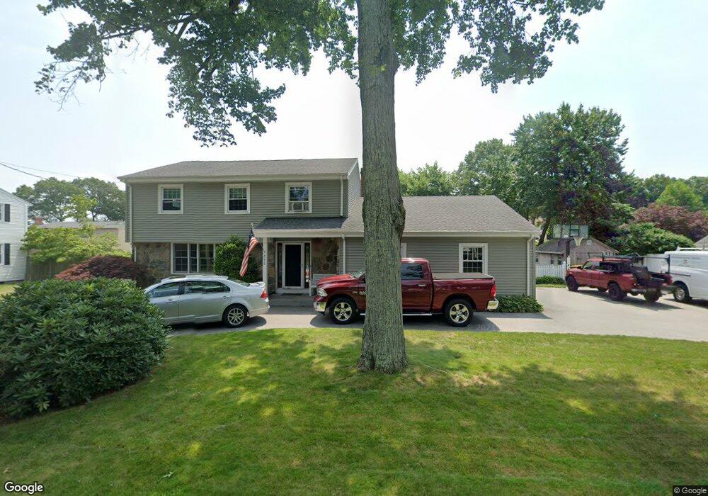
296 Elm St Somerset, MA 02726
Somerset Reservoir NeighborhoodEstimated Value: $616,846 - $761,000
3
Beds
3
Baths
2,384
Sq Ft
$296/Sq Ft
Est. Value
About This Home
This home is located at 296 Elm St, Somerset, MA 02726 and is currently estimated at $706,212, approximately $296 per square foot. 296 Elm St is a home located in Bristol County with nearby schools including North Elementary School, Somerset Middle School, and SCEC Life Academy.
Ownership History
Date
Name
Owned For
Owner Type
Purchase Details
Closed on
Nov 30, 2001
Sold by
Mendonca Steven G and Mendonca Renee C
Bought by
Shea Michael L and Shea Carol A
Current Estimated Value
Purchase Details
Closed on
Apr 3, 1996
Sold by
Reed William J and Reed Carolyn E
Bought by
Mendonca Steven G and Mendonca Renee C
Create a Home Valuation Report for This Property
The Home Valuation Report is an in-depth analysis detailing your home's value as well as a comparison with similar homes in the area
Home Values in the Area
Average Home Value in this Area
Purchase History
| Date | Buyer | Sale Price | Title Company |
|---|---|---|---|
| Shea Michael L | $260,000 | -- | |
| Shea Michael L | $260,000 | -- | |
| Mendonca Steven G | $155,000 | -- | |
| Mendonca Steven G | $155,000 | -- |
Source: Public Records
Mortgage History
| Date | Status | Borrower | Loan Amount |
|---|---|---|---|
| Open | Mendonca Steven G | $199,000 | |
| Closed | Mendonca Steven G | $200,000 |
Source: Public Records
Tax History Compared to Growth
Tax History
| Year | Tax Paid | Tax Assessment Tax Assessment Total Assessment is a certain percentage of the fair market value that is determined by local assessors to be the total taxable value of land and additions on the property. | Land | Improvement |
|---|---|---|---|---|
| 2025 | $6,662 | $500,900 | $185,000 | $315,900 |
| 2024 | $6,247 | $488,400 | $185,000 | $303,400 |
| 2023 | $5,620 | $443,200 | $168,000 | $275,200 |
| 2022 | $5,203 | $391,500 | $145,200 | $246,300 |
| 2021 | $5,248 | $357,500 | $131,400 | $226,100 |
| 2020 | $5,149 | $338,300 | $131,200 | $207,100 |
| 2019 | $5,796 | $317,600 | $131,200 | $186,400 |
| 2018 | $4,954 | $292,100 | $127,200 | $164,900 |
| 2017 | $4,940 | $283,900 | $127,200 | $156,700 |
| 2016 | $4,971 | $283,900 | $127,200 | $156,700 |
| 2015 | $4,594 | $264,800 | $119,700 | $145,100 |
| 2014 | $6,492 | $268,800 | $114,200 | $154,600 |
Source: Public Records
Map
Nearby Homes
- 435 Fairway Dr
- 107 Manchester Ave
- 259 Lynch Ave
- 95 Samson Ave
- 65 Marvel St
- 171 Marvel St
- 602 Regan Rd
- 1067 Bark St
- 112 Rounseville Ave
- 3094 Millers Ln
- 122 Robin Ln
- 3076 County St
- 3057 Clubhouse Dr
- 3064 Clubhouse Dr
- 3035 Clubhouse Dr Unit 6
- 3035 Clubhouse Dr Unit 8
- 3049 Clubhouse Dr Unit 77
- 3035 Clubhouse Dr Unit 2
- 3055 Clubhouse Dr Unit 80
- 3035 Clubhouse Dr