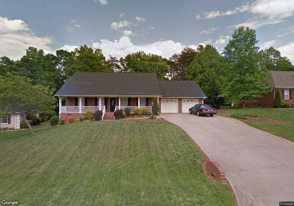
296 Lariat Dr Lincolnton, NC 28092
Estimated Value: $364,917 - $443,000
3
Beds
2
Baths
1,863
Sq Ft
$215/Sq Ft
Est. Value
About This Home
This home is located at 296 Lariat Dr, Lincolnton, NC 28092 and is currently estimated at $401,229, approximately $215 per square foot. 296 Lariat Dr is a home located in Lincoln County with nearby schools including Iron Station Elementary School, North Lincoln Middle School, and North Lincoln High School.
Ownership History
Date
Name
Owned For
Owner Type
Purchase Details
Closed on
Feb 15, 2010
Sold by
Davis Scott Craig and Davis Meredith T
Bought by
Jordan Rodney and Jordan Christine
Current Estimated Value
Home Financials for this Owner
Home Financials are based on the most recent Mortgage that was taken out on this home.
Original Mortgage
$210,000
Outstanding Balance
$137,024
Interest Rate
4.75%
Mortgage Type
New Conventional
Estimated Equity
$264,205
Purchase Details
Closed on
May 2, 2005
Sold by
Predmore William R and Predmore Patricia G
Bought by
Davis Ii Scott Craig and Davis Meredith T
Home Financials for this Owner
Home Financials are based on the most recent Mortgage that was taken out on this home.
Original Mortgage
$142,400
Interest Rate
5.88%
Mortgage Type
New Conventional
Purchase Details
Closed on
May 1, 1998
Bought by
Premore William R and Premore Patricia G
Purchase Details
Closed on
Feb 2, 1996
Bought by
Turner John R and Turner Margaret F
Purchase Details
Closed on
Jul 22, 1994
Bought by
Holliday Johnnie S and Holli Tammy S
Create a Home Valuation Report for This Property
The Home Valuation Report is an in-depth analysis detailing your home's value as well as a comparison with similar homes in the area
Home Values in the Area
Average Home Value in this Area
Purchase History
| Date | Buyer | Sale Price | Title Company |
|---|---|---|---|
| Jordan Rodney | $210,000 | None Available | |
| Davis Ii Scott Craig | $178,000 | None Available | |
| Premore William R | $142,000 | -- | |
| Turner John R | $128,000 | -- | |
| Holliday Johnnie S | $122,500 | -- |
Source: Public Records
Mortgage History
| Date | Status | Borrower | Loan Amount |
|---|---|---|---|
| Open | Jordan Rodney | $210,000 | |
| Previous Owner | Davis Ii Scott Craig | $142,400 |
Source: Public Records
Tax History Compared to Growth
Tax History
| Year | Tax Paid | Tax Assessment Tax Assessment Total Assessment is a certain percentage of the fair market value that is determined by local assessors to be the total taxable value of land and additions on the property. | Land | Improvement |
|---|---|---|---|---|
| 2025 | $2,095 | $313,359 | $43,000 | $270,359 |
| 2024 | $2,075 | $313,359 | $43,000 | $270,359 |
| 2023 | $2,070 | $313,359 | $43,000 | $270,359 |
| 2022 | $1,711 | $214,558 | $34,000 | $180,558 |
| 2021 | $1,711 | $214,558 | $34,000 | $180,558 |
| 2020 | $1,553 | $214,558 | $34,000 | $180,558 |
| 2019 | $1,510 | $214,558 | $34,000 | $180,558 |
| 2018 | $1,516 | $193,040 | $32,000 | $161,040 |
| 2017 | $1,372 | $193,040 | $32,000 | $161,040 |
| 2016 | $1,372 | $193,040 | $32,000 | $161,040 |
| 2015 | $1,469 | $193,040 | $32,000 | $161,040 |
| 2014 | $1,421 | $193,865 | $32,000 | $161,865 |
Source: Public Records
Map
Nearby Homes
- 370 Sherrill Farm Rd
- 2583 Wallace Acres Ln
- 2914 Weatherfield Dr
- 2911 Weatherfield Dr
- 2983 Tavistock Ln
- lot 22 Weatherwood Dr Unit 22
- 2794 N Carolina Highway 150
- 2984 N Carolina 27
- 3478 N Carolina Highway 150
- 000 Curveview Rd
- 2546 N Carolina Highway 150
- 1471 Arden Dr
- 1404 Old Mill Rd
- 1335 Huckleberry Dr
- 3164 Andrew Link Rd
- 741 Sunridge Dr
- 2202 Carpenter Farms Dr
- 1818 Maple Ln
- 00 Mcalister Rd
- 575 Hill Rd
- 286 Lariat Dr
- 302 Lariat Dr
- 276 Lariat Dr
- 293 Lariat Dr
- 279 Lariat Dr
- 303 Lariat Dr
- 266 Lariat Dr
- 266 Lariat Dr Unit 26,27
- 250 Lariat Dr
- 249 Lariat Dr
- 3193 Fair Oaks Dr
- 3193 Fair Oaks Dr Unit 9
- 3183 Fair Oaks Dr
- 3405 Asbury Church Rd
- 226 Lariat Dr
- 306 Lariat Dr
- 210 Lariat Dr
- 213 Lariat Dr
- 3505 Asbury Church Rd
- 3555 Asbury Church Rd