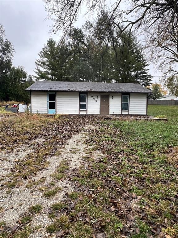
2965 NE 52nd Ct Des Moines, IA 50317
Capitol Heights NeighborhoodEstimated payment $1,035/month
Highlights
- 0.85 Acre Lot
- No HOA
- Forced Air Heating System
- Ranch Style House
- Eat-In Kitchen
About This Home
Handyman/investor special. Zero entry home
on nearly 1 acre lot, in county within SEP
school district. 3 beds, 1 bath with 912
square feet. Plenty of room to for a large
morton building to be built!
Home Details
Home Type
- Single Family
Est. Annual Taxes
- $2,288
Year Built
- Built in 1990
Lot Details
- 0.85 Acre Lot
- Lot Dimensions are 154x242
- Property is zoned LDR
Parking
- Gravel Driveway
Home Design
- 912 Sq Ft Home
- Ranch Style House
- Traditional Architecture
- Slab Foundation
- Asphalt Shingled Roof
- Vinyl Siding
Bedrooms and Bathrooms
- 3 Main Level Bedrooms
- 1 Full Bathroom
Utilities
- Forced Air Heating System
- Septic Tank
Additional Features
- Eat-In Kitchen
- Laundry on main level
Community Details
- No Home Owners Association
Listing and Financial Details
- Assessor Parcel Number 19001298002000
Map
Home Values in the Area
Average Home Value in this Area
Tax History
| Year | Tax Paid | Tax Assessment Tax Assessment Total Assessment is a certain percentage of the fair market value that is determined by local assessors to be the total taxable value of land and additions on the property. | Land | Improvement |
|---|---|---|---|---|
| 2025 | $2,150 | $185,600 | $55,200 | $130,400 |
| 2024 | $2,150 | $171,600 | $50,500 | $121,100 |
| 2023 | $2,262 | $171,600 | $50,500 | $121,100 |
| 2022 | $2,228 | $141,200 | $41,900 | $99,300 |
| 2021 | $2,136 | $141,200 | $41,900 | $99,300 |
| 2020 | $2,190 | $128,800 | $38,200 | $90,600 |
| 2019 | $1,908 | $128,800 | $38,200 | $90,600 |
| 2018 | $1,912 | $113,700 | $33,200 | $80,500 |
| 2017 | $2,028 | $113,700 | $33,200 | $80,500 |
| 2016 | $2,020 | $108,500 | $31,300 | $77,200 |
| 2015 | $2,020 | $108,500 | $31,300 | $77,200 |
| 2014 | $1,922 | $102,800 | $28,700 | $74,100 |
Property History
| Date | Event | Price | List to Sale | Price per Sq Ft |
|---|---|---|---|---|
| 11/22/2025 11/22/25 | Price Changed | $159,900 | -3.1% | $175 / Sq Ft |
| 10/30/2025 10/30/25 | For Sale | $165,000 | -- | $181 / Sq Ft |
Purchase History
| Date | Type | Sale Price | Title Company |
|---|---|---|---|
| Warranty Deed | $93,000 | -- | |
| Warranty Deed | $76,500 | -- |
Mortgage History
| Date | Status | Loan Amount | Loan Type |
|---|---|---|---|
| Open | $18,675 | Credit Line Revolving | |
| Open | $74,625 | Fannie Mae Freddie Mac | |
| Previous Owner | $60,000 | No Value Available |
Source: Des Moines Area Association of REALTORS®
MLS Number: 729484
APN: 190-01298002000
Disclaimer: Certain information contained herein is derived from information provided by parties other than Homes.com. All information provided is deemed reliable, but is not guaranteed to be accurate and should be independently verified.
![]() IDX information is provided exclusively for personal, non-commercial use, and may not be used for any purpose other than to identify prospective properties consumers may be interested in purchasing. Information is deemed reliable but not guaranteed.
IDX information is provided exclusively for personal, non-commercial use, and may not be used for any purpose other than to identify prospective properties consumers may be interested in purchasing. Information is deemed reliable but not guaranteed.
- 5221 Village Run Ave Unit 1503
- 5645 Walnut Ridge Dr
- 5650 Walnut Ridge Dr
- 5659 Walnut Ridge Dr
- 5687 Walnut Ridge Dr
- 5655 Walnut Ridge Dr
- 5695 Walnut Ridge Dr
- 5675 Walnut Ridge Dr
- 5698 Walnut Ridge Dr
- 5690 Walnut Ridge Dr
- 5667 Walnut Ridge Dr
- 5663 Walnut Ridge Dr
- 5686 Walnut Ridge Dr
- 5634 Walnut Ridge Dr
- 5678 Walnut Ridge Dr
- 5651 Walnut Ridge Dr
- 5642 Walnut Ridge Dr
- 5609 Walnut Ridge Dr
- 5683 Walnut Ridge Dr
- 5615 Walnut Ridge Dr
- 3799 Village Run Dr
- 5115 NE 23rd Ave
- 2165 Copper Wynd Dr
- 1827 34th Ave SW
- 1490 34th Ave SW
- 4216 50th St
- 4282 E 50th St
- 4014 Hubbell Ave
- 935 Sherrylynn Blvd
- 3909 Hubbell Ave
- 5327 Jennifer Dr
- 770 N Pleasant Hill Blvd
- 660 N Pleasant Hill Blvd
- 595 N Pleasant Hill Blvd
- 526 43rd St SW
- 3722 Hubbell Ave
- 3600 Kennedy Dr
- 3540 E Douglas Ave
- 1022 Williams St Unit 1020 Williams Street
- 799 NE 60th St
