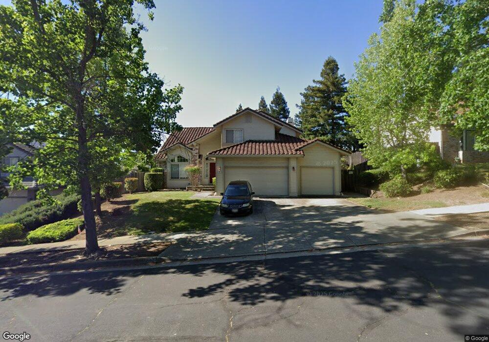
2971 Rustle Ct Fairfield, CA 94534
Estimated Value: $680,000 - $749,996
4
Beds
3
Baths
2,298
Sq Ft
$316/Sq Ft
Est. Value
About This Home
This home is located at 2971 Rustle Ct, Fairfield, CA 94534 and is currently estimated at $726,749, approximately $316 per square foot. 2971 Rustle Ct is a home located in Solano County with nearby schools including K. I. Jones Elementary School, Angelo Rodriguez High School, and We R Family Christian School.
Ownership History
Date
Name
Owned For
Owner Type
Purchase Details
Closed on
Oct 2, 2014
Sold by
Ryia C John and Ryia Susan L
Bought by
Bito Ramon I and Bito Maria Anjela P
Current Estimated Value
Home Financials for this Owner
Home Financials are based on the most recent Mortgage that was taken out on this home.
Original Mortgage
$402,014
Outstanding Balance
$311,568
Interest Rate
4.4%
Mortgage Type
FHA
Estimated Equity
$415,181
Create a Home Valuation Report for This Property
The Home Valuation Report is an in-depth analysis detailing your home's value as well as a comparison with similar homes in the area
Purchase History
| Date | Buyer | Sale Price | Title Company |
|---|---|---|---|
| Bito Ramon I | $439,000 | Fidelity National Title Co |
Source: Public Records
Mortgage History
| Date | Status | Borrower | Loan Amount |
|---|---|---|---|
| Open | Bito Ramon I | $402,014 |
Source: Public Records
Tax History
| Year | Tax Paid | Tax Assessment Tax Assessment Total Assessment is a certain percentage of the fair market value that is determined by local assessors to be the total taxable value of land and additions on the property. | Land | Improvement |
|---|---|---|---|---|
| 2025 | $6,211 | $527,603 | $120,181 | $407,422 |
| 2024 | $6,211 | $517,259 | $117,825 | $399,434 |
| 2023 | $6,031 | $507,117 | $115,515 | $391,602 |
| 2022 | $5,961 | $497,174 | $113,250 | $383,924 |
| 2021 | $5,904 | $487,427 | $111,030 | $376,397 |
| 2020 | $5,774 | $482,430 | $109,892 | $372,538 |
| 2019 | $5,640 | $472,972 | $107,738 | $365,234 |
| 2018 | $5,808 | $463,699 | $105,626 | $358,073 |
| 2017 | $5,556 | $454,607 | $103,555 | $351,052 |
| 2016 | $5,520 | $445,694 | $101,525 | $344,169 |
| 2015 | $5,193 | $439,000 | $100,000 | $339,000 |
| 2014 | $4,641 | $386,257 | $113,147 | $273,110 |
Source: Public Records
Map
Nearby Homes
- 2903 Burbank Dr
- 2848 Howe Ct
- 2810 Miller Ct
- 185 Canby Way
- 2222 Madrone Dr
- 3456 Norwalk Place
- 3114 Lomita Ct
- 2125 Mecca Ct
- 3451 Nantucket Dr
- 3511 Norwalk Place
- 2045 Dorland Dr
- 2051 Barbour Dr
- 1858 Barbour Dr
- 2837 Watson Ct
- 1437 Shelby Dr
- 1866 New Jersey St
- 1654 Minnesota St
- 2517 Kingsmill Ln
- 1949 New Jersey St
- 1318 Cleveland St
- 2977 Rustle Ct
- 2965 Rustle Ct
- 1757 Gillespie Dr
- 1752 Kearny Ct
- 2983 Rustle Ct
- 2976 Rustle Ct
- 2982 Rustle Ct
- 1751 Gillespie Dr
- 2970 Rustle Ct
- 1758 Kearny Ct
- 2988 Rustle Ct
- 1746 Kearny Ct
- 2989 Rustle Ct
- 1760 Gillespie Dr
- 1760 Gillespie Dr
- 1754 Gillespie Dr
- 2994 Rustle Ct
- 1766 Gillespie Dr
- 1745 Gillespie Dr
- 1755 Kearny Ct
Your Personal Tour Guide
Ask me questions while you tour the home.