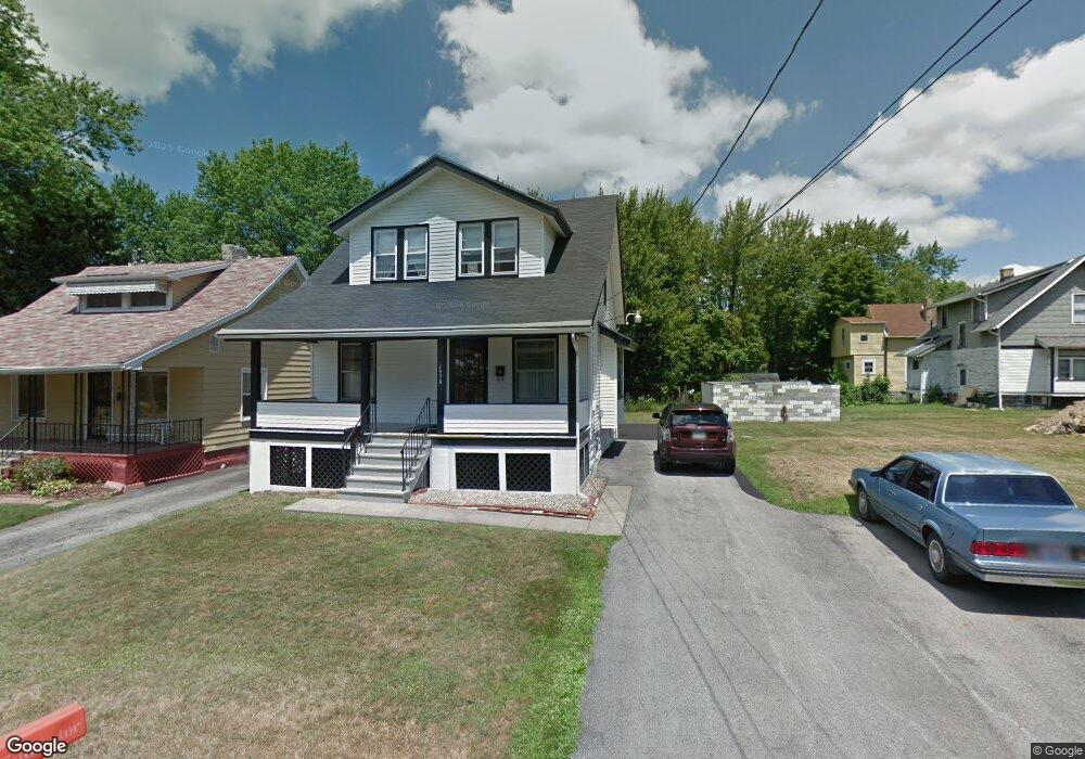
2978 Northwood Ave Youngstown, OH 44505
McGuffey Heights NeighborhoodEstimated Value: $52,074 - $85,000
3
Beds
1
Bath
1,046
Sq Ft
$63/Sq Ft
Est. Value
About This Home
This home is located at 2978 Northwood Ave, Youngstown, OH 44505 and is currently estimated at $66,358, approximately $63 per square foot. 2978 Northwood Ave is a home located in Mahoning County with nearby schools including M.L. King Elementary School, Williamson Elementary School, and East High School.
Ownership History
Date
Name
Owned For
Owner Type
Purchase Details
Closed on
Jan 22, 2025
Sold by
Lynch Margie M
Bought by
Lynch Jerome L
Current Estimated Value
Purchase Details
Closed on
Nov 3, 2008
Sold by
Pettway Lydia and Pettway John
Bought by
Lynch Margie M
Purchase Details
Closed on
Nov 14, 2006
Sold by
Lynch Jerome L
Bought by
Lynch Margie M
Purchase Details
Closed on
Mar 6, 1975
Bought by
Robinson Jessie and Robinson Lorena
Create a Home Valuation Report for This Property
The Home Valuation Report is an in-depth analysis detailing your home's value as well as a comparison with similar homes in the area
Home Values in the Area
Average Home Value in this Area
Purchase History
| Date | Buyer | Sale Price | Title Company |
|---|---|---|---|
| Lynch Jerome L | -- | None Listed On Document | |
| Lynch Margie M | $1,000 | Attorney | |
| Lynch Margie M | -- | Attorney | |
| Robinson Jessie | -- | -- |
Source: Public Records
Tax History Compared to Growth
Tax History
| Year | Tax Paid | Tax Assessment Tax Assessment Total Assessment is a certain percentage of the fair market value that is determined by local assessors to be the total taxable value of land and additions on the property. | Land | Improvement |
|---|---|---|---|---|
| 2024 | $3 | $5,970 | $400 | $5,570 |
| 2023 | $3 | $5,970 | $400 | $5,570 |
| 2022 | $3 | $2,080 | $340 | $1,740 |
| 2021 | $3 | $2,080 | $340 | $1,740 |
| 2020 | $3 | $2,080 | $340 | $1,740 |
| 2019 | $6 | $1,930 | $320 | $1,610 |
| 2018 | $6 | $1,930 | $320 | $1,610 |
| 2017 | $3 | $1,930 | $320 | $1,610 |
| 2016 | $3 | $2,370 | $320 | $2,050 |
| 2015 | $3 | $2,370 | $320 | $2,050 |
| 2014 | $3 | $2,370 | $320 | $2,050 |
| 2013 | $3 | $2,370 | $320 | $2,050 |
Source: Public Records
Map
Nearby Homes
- 1720 Jacobs Rd
- 1214 Brighton St
- 2051 Blair Ave
- V/L Jacobs Rd
- 2951 Megan Cir
- 2831 Benford Ln
- 2954 Megan Cir
- 1003 Liberty Rd
- 1325 Miami Ave
- 902 Miami St
- 665 Wendemere Dr
- 1538 Republic Ave
- 663 Meadowland Dr
- 366 Westview Ave
- 227 Greeley Ln
- 405 Drake Ave
- 0 Homestead Rd
- 531 Meadowland Dr
- 279 Parish Ave
- 566 Sunshine Ave