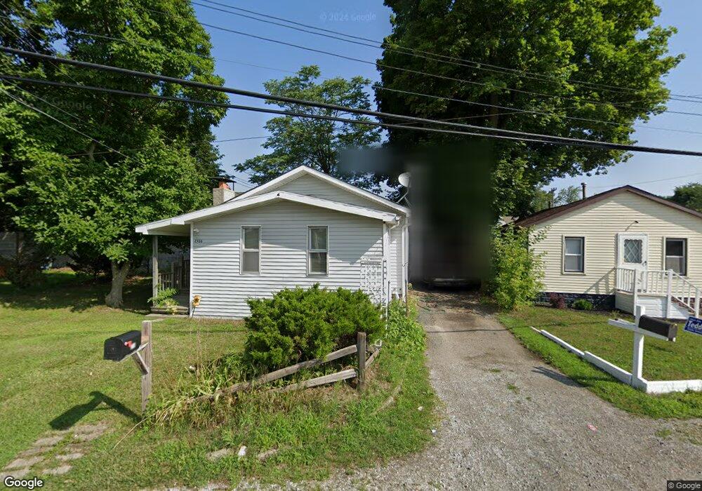
2986 Hensman St Keego Harbor, MI 48320
Estimated Value: $138,000 - $219,000
3
Beds
1
Bath
913
Sq Ft
$187/Sq Ft
Est. Value
About This Home
This home is located at 2986 Hensman St, Keego Harbor, MI 48320 and is currently estimated at $170,808, approximately $187 per square foot. 2986 Hensman St is a home located in Oakland County with nearby schools including Momentum Academy, Waterford Montessori Academy, and The Susan And Rabbi Harold Loss Ecc.
Ownership History
Date
Name
Owned For
Owner Type
Purchase Details
Closed on
Aug 12, 2008
Sold by
Davis Kevin A and Mortgage Electronic Registrati
Bought by
Us Bank Na
Current Estimated Value
Purchase Details
Closed on
Feb 12, 1999
Sold by
Jaroneski Jason
Bought by
Davis Kevin A
Home Financials for this Owner
Home Financials are based on the most recent Mortgage that was taken out on this home.
Original Mortgage
$61,759
Interest Rate
6.8%
Create a Home Valuation Report for This Property
The Home Valuation Report is an in-depth analysis detailing your home's value as well as a comparison with similar homes in the area
Home Values in the Area
Average Home Value in this Area
Purchase History
| Date | Buyer | Sale Price | Title Company |
|---|---|---|---|
| Us Bank Na | $68,000 | None Available | |
| Davis Kevin A | $61,800 | -- |
Source: Public Records
Mortgage History
| Date | Status | Borrower | Loan Amount |
|---|---|---|---|
| Previous Owner | Davis Kevin A | $61,759 |
Source: Public Records
Tax History Compared to Growth
Tax History
| Year | Tax Paid | Tax Assessment Tax Assessment Total Assessment is a certain percentage of the fair market value that is determined by local assessors to be the total taxable value of land and additions on the property. | Land | Improvement |
|---|---|---|---|---|
| 2024 | $1,909 | $62,800 | $0 | $0 |
| 2023 | $1,820 | $57,540 | $0 | $0 |
| 2022 | $1,791 | $51,320 | $0 | $0 |
| 2021 | $1,728 | $45,120 | $0 | $0 |
| 2020 | $1,661 | $40,690 | $0 | $0 |
| 2019 | $1,665 | $38,830 | $0 | $0 |
| 2018 | $1,650 | $36,040 | $0 | $0 |
| 2017 | $1,547 | $33,500 | $0 | $0 |
| 2016 | $1,553 | $29,400 | $0 | $0 |
| 2015 | -- | $28,720 | $0 | $0 |
| 2014 | -- | $24,650 | $0 | $0 |
| 2011 | -- | $24,700 | $0 | $0 |
Source: Public Records
Map
Nearby Homes
- 2960 Glenbroke St
- 1970 Beechmont St
- 2820 Wall St
- 1700 Maddy Ln
- 1660 Beechmont St
- 2132 Brock St
- 2952 Prynne St
- 1661 Cass Lake Rd Unit D
- 1775 Woodland Ave
- 1959 Woodland Ave
- 2182 Park Cir
- 2918 Nagle Ct
- 1540 Cass Lake Rd
- 2265 Maddy Ln
- 1517 Kessler Ave
- 2583 Empire Dr
- 2420 Garland St
- 2428 Willow Beach St
- 2630 Depew Dr
- 1796 Briarcliff St
- 2978 Hensman St
- 2959 Glenbroke St
- 1955 Cass Lake Rd
- 2951 Glenbroke St
- 2943 Glenbroke St
- 2968 Hensman St
- 2967 Glenbroke St
- 2933 Glenbroke St
- 2927 Glenbroke St
- 1905 Cass Lake Rd
- 2960 Hensman St
- 1967 Cass Lake Rd
- 2921 Glenbroke St
- 2936 Glenbroke St Unit Bldg-Unit
- 2936 Glenbroke St
- 2952 Glenbroke St
- 2944 Glenbroke St
- 2940 Hensman St
- 3009 Glenbroke St
- 2968 Glenbroke St