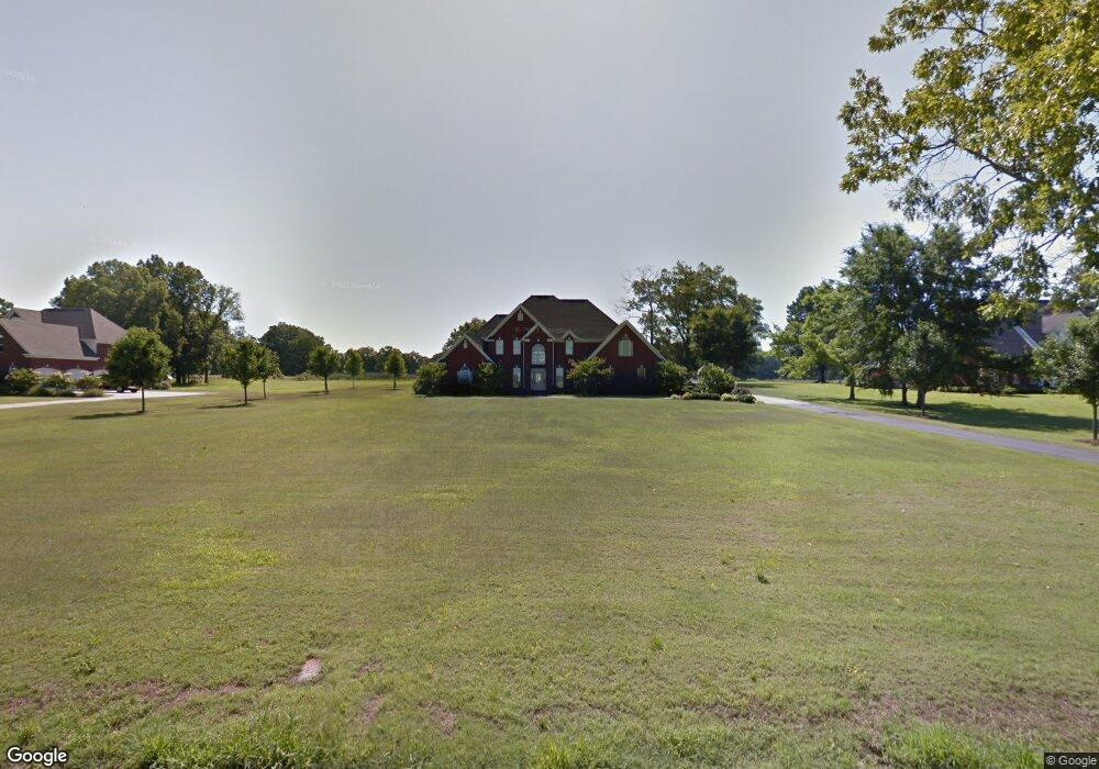
2986 Quail Ridge Rd West Point, MS 39773
Estimated Value: $655,000 - $742,085
4
Beds
--
Bath
4,330
Sq Ft
$165/Sq Ft
Est. Value
About This Home
This home is located at 2986 Quail Ridge Rd, West Point, MS 39773 and is currently estimated at $713,271, approximately $164 per square foot. 2986 Quail Ridge Rd is a home located in Clay County with nearby schools including East Side Elementary School, West Clay Elementary School, and Church Hill Elementary School.
Ownership History
Date
Name
Owned For
Owner Type
Purchase Details
Closed on
Jun 17, 2005
Sold by
Southern Retail Development
Bought by
Ferguson Randy L and Ferguson Candy M
Current Estimated Value
Create a Home Valuation Report for This Property
The Home Valuation Report is an in-depth analysis detailing your home's value as well as a comparison with similar homes in the area
Home Values in the Area
Average Home Value in this Area
Purchase History
| Date | Buyer | Sale Price | Title Company |
|---|---|---|---|
| Ferguson Randy L | -- | -- |
Source: Public Records
Tax History Compared to Growth
Tax History
| Year | Tax Paid | Tax Assessment Tax Assessment Total Assessment is a certain percentage of the fair market value that is determined by local assessors to be the total taxable value of land and additions on the property. | Land | Improvement |
|---|---|---|---|---|
| 2024 | $2,534 | $47,732 | $2,712 | $45,020 |
| 2023 | $4,687 | $43,936 | $2,712 | $41,224 |
| 2022 | $2,303 | $43,936 | $2,712 | $41,224 |
| 2021 | $2,287 | $43,936 | $2,712 | $41,224 |
| 2020 | $2,312 | $43,936 | $2,712 | $41,224 |
| 2019 | $2,272 | $45,827 | $2,712 | $43,115 |
| 2018 | $2,175 | $45,827 | $2,712 | $43,115 |
| 2017 | $2,175 | $45,827 | $2,712 | $43,115 |
| 2016 | $2,087 | $45,827 | $2,712 | $43,115 |
| 2015 | $2,010 | $43,038 | $2,712 | $40,326 |
| 2014 | $1,854 | $43,038 | $2,712 | $40,326 |
| 2013 | $1,854 | $43,038 | $2,712 | $40,326 |
Source: Public Records
Map
Nearby Homes
- 120 Nelda Dr
- 0 Riverchase Dr
- 164 Deer Run Rd
- 0 Officers Lake Rd
- 1873 Sandy Land Rd
- 145 Brownlee Dr
- 45 Greenleaf Ln
- 1 Sleepy Hollow Dr
- 1372 Mike Parra Rd
- 1 W Jess Lyons Rd
- 4 W Jess Lyons Rd
- 3 W Jess Lyons Rd
- 6 W Jess Lyons Rd
- 5 W Jess Lyons Rd
- 0 Downs Rd
- 0 Mississippi 373
- 230 Acorn Aly
- 134 S Perkins Rd
- 0 Hickory Ridge
- 170 Saber Trail
- 2902 Quail Ridge Rd
- 2950 Quail Ridge Rd
- 2860 Quail Ridge Rd
- 2921 Quail Ridge Rd
- 2549 Quail Ridge Rd
- 2553 Quail Ridge Rd
- 2647 Quail Ridge Rd
- 2761 Quail Ridge Rd
- 2861 Quail Ridge Rd
- 10608 Mallard Point
- 10636 Mallard Point
- 10526 Mallard Point
- 115 Mallard Point Dr
- 108 Torbert Dr
- 174 Humphries Cove Rd
- 121 Mallard Point Dr
- 10465 Nelda Dr
- 10465 Nelda Dr
- 33 Nelda Dr
- 10575 Melba Dr