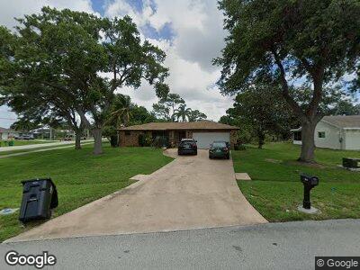
299 SW Langfield Ave Port Saint Lucie, FL 34984
Canal Pointe NeighborhoodEstimated Value: $357,101 - $431,000
3
Beds
2
Baths
1,700
Sq Ft
$231/Sq Ft
Est. Value
About This Home
This home is located at 299 SW Langfield Ave, Port Saint Lucie, FL 34984 and is currently estimated at $393,025, approximately $231 per square foot. 299 SW Langfield Ave is a home located in St. Lucie County with nearby schools including Floresta Elementary School, Morningside Elementary School, and Northport K-8 School.
Ownership History
Date
Name
Owned For
Owner Type
Purchase Details
Closed on
Jul 15, 1999
Sold by
Witt Clifford
Bought by
Lefort Robert M and Lefort Joyette C
Current Estimated Value
Home Financials for this Owner
Home Financials are based on the most recent Mortgage that was taken out on this home.
Original Mortgage
$72,344
Interest Rate
7.66%
Mortgage Type
FHA
Create a Home Valuation Report for This Property
The Home Valuation Report is an in-depth analysis detailing your home's value as well as a comparison with similar homes in the area
Home Values in the Area
Average Home Value in this Area
Purchase History
| Date | Buyer | Sale Price | Title Company |
|---|---|---|---|
| Lefort Robert M | $79,000 | -- |
Source: Public Records
Mortgage History
| Date | Status | Borrower | Loan Amount |
|---|---|---|---|
| Closed | Lefort Joyette | $319,500 | |
| Closed | Lefort Joyette | $37,000 | |
| Closed | Lefort Robert | $117,600 | |
| Closed | Lefort Robert M | $94,750 | |
| Closed | Lefort Robert M | $72,344 | |
| Closed | Lefort Robert M | $72,344 |
Source: Public Records
Tax History Compared to Growth
Tax History
| Year | Tax Paid | Tax Assessment Tax Assessment Total Assessment is a certain percentage of the fair market value that is determined by local assessors to be the total taxable value of land and additions on the property. | Land | Improvement |
|---|---|---|---|---|
| 2024 | $1,387 | $79,388 | -- | -- |
| 2023 | $1,387 | $77,076 | $0 | $0 |
| 2022 | $1,283 | $74,832 | $0 | $0 |
| 2021 | $1,207 | $72,653 | $0 | $0 |
| 2020 | $1,214 | $71,650 | $0 | $0 |
| 2019 | $1,218 | $70,040 | $0 | $0 |
| 2018 | $1,167 | $68,735 | $0 | $0 |
| 2017 | $1,394 | $126,800 | $28,300 | $98,500 |
| 2016 | $1,393 | $106,500 | $21,200 | $85,300 |
| 2015 | $1,405 | $77,000 | $11,800 | $65,200 |
| 2014 | $1,366 | $64,960 | $0 | $0 |
Source: Public Records
Map
Nearby Homes
- 298 SW Airview Ave
- 2433 SW Cooper Ln
- 231 SW Moselle Ave
- 282 SW Fairchild Ave
- 2445 SW Falcon Cir
- 2442 SW Lafayette St
- 2341 SW Cooper Ln
- 2624 SW Harem Cir
- 2329 SW Mountwell St
- 2613 SW Harem Cir
- 178 SW Essex Dr
- 163 SE Osprey Ridge
- 2473 SE Warwick St
- 2618 SW River Shore Dr
- 131 SW Essex Dr
- 130 SW Airview Ave
- 745 SE Bloomfield Rd
- 13865 SE Blackwood Dr
- 399 SE Mulberry Way
- 777 SE Bloomfield Rd
- 299 SW Langfield Ave
- 297 SW Langfield Ave
- 290 SW Airview Ave
- 282 SW Airview Ave
- 2450 SW Bayshore Blvd
- 274 SW Airview Ave
- 2458 SW Bayshore Blvd
- 2473 SW Bayshore Blvd
- 2442 SW Bayshore Blvd
- 2466 SW Bayshore Blvd
- 291 SW Langfield Ave
- 266 SW Airview Ave
- 2434 SW Bayshore Blvd
- 287 SW Airview Ave
- 281 SW Airview Ave
- 295 SW Airview Ave
- 2426 SW Bayshore Blvd
- 273 SW Airview Ave
- 287 SW Langfield Ave
- 258 SW Airview Ave