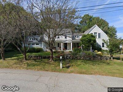
3 Olde Fort Rd Cape Elizabeth, ME 04107
Estimated Value: $1,043,000 - $1,510,000
4
Beds
3
Baths
2,612
Sq Ft
$475/Sq Ft
Est. Value
About This Home
This home is located at 3 Olde Fort Rd, Cape Elizabeth, ME 04107 and is currently estimated at $1,241,184, approximately $475 per square foot. 3 Olde Fort Rd is a home located in Cumberland County with nearby schools including Pond Cove Elementary School, Cape Elizabeth Middle School, and Cape Elizabeth High School.
Ownership History
Date
Name
Owned For
Owner Type
Purchase Details
Closed on
Nov 3, 2006
Sold by
Morris James M and Morris Lisa M
Bought by
Bosworth Kevin and Bosworth Anne
Current Estimated Value
Home Financials for this Owner
Home Financials are based on the most recent Mortgage that was taken out on this home.
Original Mortgage
$452,000
Interest Rate
6.47%
Mortgage Type
Purchase Money Mortgage
Create a Home Valuation Report for This Property
The Home Valuation Report is an in-depth analysis detailing your home's value as well as a comparison with similar homes in the area
Home Values in the Area
Average Home Value in this Area
Purchase History
| Date | Buyer | Sale Price | Title Company |
|---|---|---|---|
| Bosworth Kevin | -- | -- |
Source: Public Records
Mortgage History
| Date | Status | Borrower | Loan Amount |
|---|---|---|---|
| Open | Boswoeth Kevin M | $500,000 | |
| Closed | Bosworth Kevin M | $195,000 | |
| Closed | Bosworth Kevin M | $300,000 | |
| Closed | Bosworth Kevin M | $153,000 | |
| Closed | Bosworth Kevin | $452,000 | |
| Previous Owner | Morris James M | $225,000 |
Source: Public Records
Tax History Compared to Growth
Tax History
| Year | Tax Paid | Tax Assessment Tax Assessment Total Assessment is a certain percentage of the fair market value that is determined by local assessors to be the total taxable value of land and additions on the property. | Land | Improvement |
|---|---|---|---|---|
| 2024 | $11,349 | $1,031,700 | $490,300 | $541,400 |
| 2023 | $23,048 | $1,031,700 | $490,300 | $541,400 |
| 2022 | $11,973 | $566,100 | $194,800 | $371,300 |
| 2021 | $11,469 | $566,100 | $194,800 | $371,300 |
| 2020 | $11,277 | $566,100 | $194,800 | $371,300 |
| 2019 | $11,098 | $563,900 | $194,800 | $369,100 |
| 2018 | $10,725 | $563,900 | $194,800 | $369,100 |
| 2017 | $10,150 | $563,900 | $194,800 | $369,100 |
| 2016 | $9,891 | $563,900 | $194,800 | $369,100 |
| 2015 | $9,519 | $563,900 | $194,800 | $369,100 |
| 2013 | $9,180 | $563,900 | $194,800 | $369,100 |
Source: Public Records
Map
Nearby Homes
- 20 Robinhood Rd
- 1055 Shore Rd
- 41 Warren Ave
- 51 Woodland Rd Unit 1
- 28 Stone Dr
- 9 Charlotte St
- 25 Graffam Rd
- 28 Henry St
- 109 Hillside Ave
- 22 Vincent St
- 23 Blue Meadow Ln Unit 23
- 57 Lowell St
- 529 Mitchell Rd
- 142 Ocean House Rd
- 1 Solar Way Unit 1
- 3 Solar Way Unit 3
- 539 Mitchell Rd
- 43 O'Neil St
- 61 O'Neil St
- 4 Beaufort St