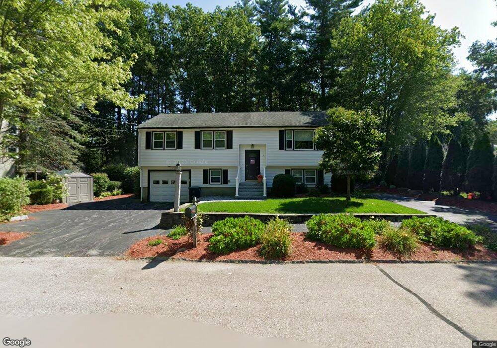
3 Pollard Rd Nashua, NH 03062
Southwest Nashua NeighborhoodEstimated Value: $495,735 - $546,000
3
Beds
1
Bath
1,094
Sq Ft
$479/Sq Ft
Est. Value
About This Home
This home is located at 3 Pollard Rd, Nashua, NH 03062 and is currently estimated at $524,184, approximately $479 per square foot. 3 Pollard Rd is a home located in Hillsborough County with nearby schools including New Searles School, Fairgrounds Middle School, and Nashua High School South.
Ownership History
Date
Name
Owned For
Owner Type
Purchase Details
Closed on
Aug 19, 2013
Sold by
Green Karen A
Bought by
Karen A Green T A and Karen Green
Current Estimated Value
Purchase Details
Closed on
Oct 12, 1979
Bought by
Karen A Green T
Create a Home Valuation Report for This Property
The Home Valuation Report is an in-depth analysis detailing your home's value as well as a comparison with similar homes in the area
Home Values in the Area
Average Home Value in this Area
Purchase History
| Date | Buyer | Sale Price | Title Company |
|---|---|---|---|
| Karen A Green T A | -- | -- | |
| Karen A Green T | -- | -- | |
| Karen A Green T | -- | -- |
Source: Public Records
Mortgage History
| Date | Status | Borrower | Loan Amount |
|---|---|---|---|
| Previous Owner | Karen A Green T | $152,000 | |
| Previous Owner | Karen A Green T | $160,000 | |
| Previous Owner | Karen A Green T | $75,000 |
Source: Public Records
Tax History
| Year | Tax Paid | Tax Assessment Tax Assessment Total Assessment is a certain percentage of the fair market value that is determined by local assessors to be the total taxable value of land and additions on the property. | Land | Improvement |
|---|---|---|---|---|
| 2025 | $8,046 | $478,100 | $171,300 | $306,800 |
| 2024 | $7,602 | $478,100 | $171,300 | $306,800 |
| 2023 | $7,270 | $398,800 | $137,100 | $261,700 |
| 2022 | $7,206 | $398,800 | $137,100 | $261,700 |
| 2021 | $6,239 | $268,700 | $91,300 | $177,400 |
| 2020 | $6,075 | $268,700 | $91,300 | $177,400 |
| 2019 | $5,847 | $268,700 | $91,300 | $177,400 |
| 2018 | $5,699 | $268,700 | $91,300 | $177,400 |
| 2017 | $5,547 | $215,100 | $75,100 | $140,000 |
| 2016 | $5,393 | $215,100 | $75,100 | $140,000 |
| 2015 | $5,276 | $215,100 | $75,100 | $140,000 |
| 2014 | $5,173 | $215,100 | $75,100 | $140,000 |
Source: Public Records
Map
Nearby Homes
- 4 Henry David Dr Unit 103
- 4 Henry David Dr Unit 203
- 2 Henry David Dr Unit 207
- 20 Nightingale Rd
- 2 Doncaster Dr
- 4 Nightingale Rd
- 4 Kittery Dr
- 16 Champagne Dr Unit U31
- 22 Taschereau Blvd
- 70 Tenby Dr
- 5 Wilderness Dr
- 154 Westwood Dr
- 103 Saranac Dr
- 14 Millbrook Dr
- 5 Ronnie Dr
- 9 Leslie Ln
- 247 Main Dunstable Rd
- 40 Hollow Ridge Dr
- 25 Kern Dr Unit 25
- 22 Kern Dr
- 5 Pollard Rd
- 36 Robin Hood Rd
- 34 Robin Hood Rd
- 51 Nottingham Dr
- 53 Nottingham Dr
- 7 Pollard Rd
- 49 Nottingham Dr
- 32 Robin Hood Rd
- 6 Pollard Rd
- 35 Robin Hood Rd
- 33 Robin Hood Rd
- 9 Pollard Rd
- 8 Pollard Rd
- 37 Robin Hood Rd
- 31 Robin Hood Rd
- 38 Robin Hood Rd
- 30 Robin Hood Rd
- 31 Robinhood Rd
- 48 Nottingham Dr
- 29 Robin Hood Rd
Your Personal Tour Guide
Ask me questions while you tour the home.