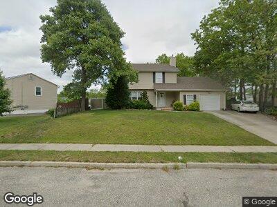
3 Pulaski Dr Barnegat, NJ 08005
Barnegat Township NeighborhoodEstimated Value: $473,000 - $543,000
4
Beds
3
Baths
1,948
Sq Ft
$259/Sq Ft
Est. Value
About This Home
This home is located at 3 Pulaski Dr, Barnegat, NJ 08005 and is currently estimated at $504,200, approximately $258 per square foot. 3 Pulaski Dr is a home located in Ocean County with nearby schools including Barnegat High School.
Ownership History
Date
Name
Owned For
Owner Type
Purchase Details
Closed on
Aug 29, 2012
Sold by
Cannizzaro Joseph and Cannizzaro Jodi
Bought by
Cannizzaro Joseph and Cannizzaro Jodi
Current Estimated Value
Purchase Details
Closed on
Nov 9, 2007
Sold by
Horner Deborah and Jannsch Deborah Ann
Bought by
Cannizzaro Richard and Cannizzaro Joanne
Home Financials for this Owner
Home Financials are based on the most recent Mortgage that was taken out on this home.
Original Mortgage
$294,085
Interest Rate
6.18%
Mortgage Type
FHA
Purchase Details
Closed on
Sep 23, 2007
Sold by
Jannsch Thomas R
Bought by
Horner Deborah and Jannsch Deborah Ann
Home Financials for this Owner
Home Financials are based on the most recent Mortgage that was taken out on this home.
Original Mortgage
$294,085
Interest Rate
6.18%
Mortgage Type
FHA
Create a Home Valuation Report for This Property
The Home Valuation Report is an in-depth analysis detailing your home's value as well as a comparison with similar homes in the area
Home Values in the Area
Average Home Value in this Area
Purchase History
| Date | Buyer | Sale Price | Title Company |
|---|---|---|---|
| Cannizzaro Joseph | -- | None Available | |
| Cannizzaro Richard | $298,700 | First American Title Ins Co | |
| Horner Deborah | -- | None Available |
Source: Public Records
Mortgage History
| Date | Status | Borrower | Loan Amount |
|---|---|---|---|
| Open | Cannizzaro Joseph | $298,496 | |
| Previous Owner | Cannizzaro Richard | $294,085 | |
| Previous Owner | Jannsch Deborah A | $150,000 |
Source: Public Records
Tax History Compared to Growth
Tax History
| Year | Tax Paid | Tax Assessment Tax Assessment Total Assessment is a certain percentage of the fair market value that is determined by local assessors to be the total taxable value of land and additions on the property. | Land | Improvement |
|---|---|---|---|---|
| 2024 | $7,260 | $249,400 | $90,300 | $159,100 |
| 2023 | $7,026 | $249,400 | $90,300 | $159,100 |
| 2022 | $7,026 | $249,400 | $90,300 | $159,100 |
| 2021 | $6,993 | $249,400 | $90,300 | $159,100 |
| 2020 | $6,961 | $249,400 | $90,300 | $159,100 |
| 2019 | $6,859 | $249,400 | $90,300 | $159,100 |
| 2018 | $6,806 | $249,400 | $90,300 | $159,100 |
| 2017 | $6,694 | $249,400 | $90,300 | $159,100 |
| 2016 | $6,557 | $249,400 | $90,300 | $159,100 |
| 2015 | $6,350 | $249,400 | $90,300 | $159,100 |
| 2014 | $6,188 | $249,400 | $90,300 | $159,100 |
Source: Public Records
Map
Nearby Homes
- 33 Pulaski Dr
- 7 Old Mill Ct
- 2 Spout Terrace
- 14 Edgewater Path
- 60 Chestnut Way Cir
- 25 Bridgewaters Passage
- 147 Spruce Cir N
- 52 Whitewater Dr
- 142 Mirage Blvd
- 150 Mirage Blvd
- 15 Tanglewood Dr
- 35 Chestnut Way Cir
- 33 Ravenwood Blvd
- 128 Lakeland Dr
- 6 Ripple Terrace
- 5 Brookview Ct
- 26 Ravenwood Blvd
- 122 Lakeland Dr
- 23 Lily Pond Ln
- 20 Hickory Cir