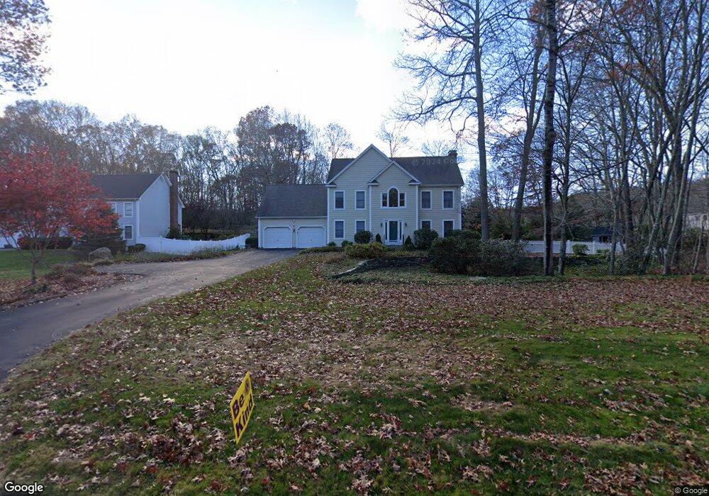
3 Spring Rock Rd East Lyme, CT 06333
Estimated Value: $684,000 - $866,000
4
Beds
3
Baths
2,849
Sq Ft
$268/Sq Ft
Est. Value
About This Home
This home is located at 3 Spring Rock Rd, East Lyme, CT 06333 and is currently estimated at $763,572, approximately $268 per square foot. 3 Spring Rock Rd is a home located in New London County with nearby schools including East Lyme Middle School, East Lyme High School, and Carelot Children's Center - East Lyme.
Ownership History
Date
Name
Owned For
Owner Type
Purchase Details
Closed on
Oct 4, 2013
Sold by
Engel Lt and Engel Kirk F
Bought by
Engel Kirk F and Engel Judith F
Current Estimated Value
Purchase Details
Closed on
May 31, 2001
Sold by
H&C Assoc Llc
Bought by
Engel Kirk F and Engel Judith F
Create a Home Valuation Report for This Property
The Home Valuation Report is an in-depth analysis detailing your home's value as well as a comparison with similar homes in the area
Home Values in the Area
Average Home Value in this Area
Purchase History
| Date | Buyer | Sale Price | Title Company |
|---|---|---|---|
| Engel Kirk F | -- | -- | |
| Engel Kirk F | $379,900 | -- |
Source: Public Records
Mortgage History
| Date | Status | Borrower | Loan Amount |
|---|---|---|---|
| Previous Owner | Engel Kirk F | $226,000 | |
| Previous Owner | Engel Kirk F | $40,000 | |
| Previous Owner | Engel Kirk F | $300,000 | |
| Previous Owner | Engel Kirk F | $304,402 |
Source: Public Records
Tax History Compared to Growth
Tax History
| Year | Tax Paid | Tax Assessment Tax Assessment Total Assessment is a certain percentage of the fair market value that is determined by local assessors to be the total taxable value of land and additions on the property. | Land | Improvement |
|---|---|---|---|---|
| 2025 | $9,874 | $352,520 | $108,080 | $244,440 |
| 2024 | $9,289 | $352,520 | $108,080 | $244,440 |
| 2023 | $8,771 | $352,520 | $108,080 | $244,440 |
| 2022 | $8,404 | $352,520 | $108,080 | $244,440 |
| 2021 | $8,264 | $289,870 | $108,080 | $181,790 |
| 2020 | $8,221 | $289,870 | $108,080 | $181,790 |
| 2019 | $8,171 | $289,870 | $108,080 | $181,790 |
| 2018 | $7,928 | $289,870 | $108,080 | $181,790 |
| 2017 | $7,583 | $289,870 | $108,080 | $181,790 |
| 2016 | $7,566 | $298,340 | $108,080 | $190,260 |
| 2015 | $7,372 | $298,340 | $108,080 | $190,260 |
| 2014 | $7,169 | $298,340 | $108,080 | $190,260 |
Source: Public Records
Map
Nearby Homes
- 496 Boston Post Rd
- 57 Spring Rock Rd
- 287 Boston Post Rd
- Waramaug Plan at Riverside Reserve
- Highland Plan at Riverside Reserve
- Hayward Plan at Riverside Reserve
- Ashford Plan at Riverside Reserve
- Lillinonah Plan at Riverside Reserve
- 16 Twin Valley Rd
- 18 Twin Valley Rd
- 270 N Bride Brook Rd
- 223 N Bride Brook Rd
- 188 4 Mile River Rd
- 23 Lords Meadow Ln
- 420 Boston Post Rd
- 13 Old Post Rd
- 5 Old Stagecoach & Boston Post Rd
- 14 Colton Rd
- 15 Short Hills Rd
- 15 Freedom Way Unit 92
- 540 Boston Post Rd
- 5 Spring Rock Rd
- 7 Spring Rock Rd
- 528 Boston Post Rd
- 3 Miranda Way
- 9 Spring Rock Rd
- 6 Spring Rock Rd
- 11 Spring Rock Rd
- 8 Spring Rock Rd
- 2 Miranda Way
- 4 Miranda Way
- 543 Boston Post Rd
- 13 Spring Rock Rd
- 10 Spring Rock Rd
- 6 Miranda Way
- 21 Spring Rock Rd
- 21 Spring Rock Rd
- 8 Miranda Way
- 12 Spring Rock Rd
- 10 Miranda Way